
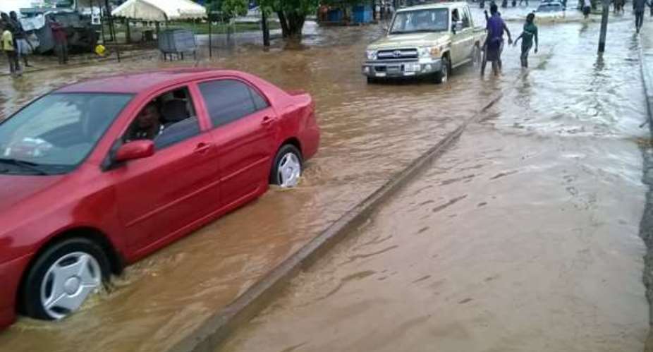
Tamale located in the Northern Region is an area which is fairly plain and low lying, and as a result the conditions are favourable against little or no flooding at all. Alarmingly, for the past four years, there has been consistent flooding of severe magnitudes in the metropolis resulting in the loss of lives and properties. Similarly, on 25th July 2017 due to an hour of heavy downpour in Tamale, a grave tragedy was experienced. I express deep condolences to the bereaved families and all those who were affected by the floods, as it is not just about this family, but a tragedy that could have affected any resident of visitors of the area. On a personal note, my own family has had the terrible experience of seeing the ravages of flood waters in Fuo. Though they escaped without any damage to life or property, the devastating memory of the rising waters, fallen crops and other atrocities will never be forgotten
Rainfall is an act of God, However, the resultant impact of damages, have no bias toward our faith, spirituality, tribe, and political persuasion or otherwise. In fact, had our leaders lived in this community they would not have been spared. Nonetheless, the problem persist. How do we as citizens of Tamale deal with the problems of flooding, or who should offer us redress for damages and loss? We know that no one is spared the havoc of floods when it occurs, however, everyone can do something about how we can prevent it.
Flooding is not akin to only developing countries but also occurs in developed areas globally. Floods cause by the tsunamis, hurricanes, storms and melting of ice are natural and unpredictable. Historically, Ghana almost has never experienced any of these natural disasters. The occasional heavy downpour that causes water banks or channels to inundate lands when it exceeds its holding capacity has become a contributory factor in the current dilemma. It is unacceptable to have an hour down pour cause such a disaster. In the light of this we can only conclude that the current infrastructures are faulty, which bring to focus and exposes the human factors, planning and engineering deficit inherent in our developmental structure in the metropolis.
In a changing world change is imminent. Ghana like the rest of the developing world has to take strides towards developing. However, this haste to develop should not be at the expense of our lives, humanity, and our social existence. We cannot stop the fast pace of infrastructural development, it is a major characteristic of urbanization. However, urbanization often leads to impermeable surfaces that increase the amount of runoff that exposes areas to flooding when it rains without efficient hydrological structures. This means if there are no avenues or place for proper drainage, the water will rise to the surface resulting in flooding. Furthermore, most of the low lying areas that were flooded, are areas where their layout schemes are either improperly set out or buildings have sprung out in inappropriate areas or on water ways.
As I mentioned on “Behind the news” in a Radio Ghana interview, the firefighting approach in this country is regrettably inadequate. Often, we wait until disaster happen or we are at cross roads before an action is taken. We are a country of highly loquacious and superstitious people who ascribe everything to anything but technology or common sense. Imagine the cars and human lives that got entangled on the flooded streets on the day of the incident. It tells us that the actions or inactions of those placed in authority leads to casualties of loved ones, which they themselves never envisaged if things are not done properly.
Accordingly, we need to be more proactive. No longer should we wait until disaster happens and city authorities rise to demolish building, while they sat unconcerned when these buildings were being built in the first place. Ways of remedying floods are expensive, yet not novel since a lot of literature abounds in this area. The lack of commitment from authorities to effect and execute what they already know on the ground, or at times the delay to implement efficiently is the bane of our woes as a society.
As a country we do not have a thematic map to solve our planning and engineering problems. One would have expected us to have flood prone maps that can enable us to develop risk maps that can highlight warning signals ahead of time to mitigate any calamities if it so arises during floods. As a land surveyor and an engineer, I find it amazing that most land use schemes in Ghana consciously or deceitfully do not include topographic details in plans. Arguably, even if they do, the scale or contour intervals are not detailed enough to portray the general profile of the area. The areas like Gumani, Gariba lodge, Fuo are low lying areas and have some portions being hydrological zones. It is therefore not surprising that those areas were ear marked as rice fields because of the water retention or runoff that existed there in the colonial era. Unfortunately, the building and other land use activities in those rice field areas or valleys have out shadowed the purpose it was designed for. Furthermore, since these structures impede the natural water channels needed for the water to flow into the requisite drains, we are only left with flooding even in the face of minimal rain.
To say these structures should be demolished may be inhumane; however we can do some reengineering in those areas and probably halt the sale of lands in those valleys not meant for residential development until we can find a tenable solution. Consequently, this decision must be without fear or favour in approving building permits in such flood prone areas. Additionally, there is a need for a profile of the area, and other relevant engineering diagnostics. Coincidentally, I remember adding an extra feet to our foundation in Fuo when we were putting up our family house due to the topography of the area, It was difficult for the water to race in during the floods. Given, if we had available the requisite warning signals and map, the security agencies and NADMO would have at least known where to be monitoring after a certain amount or period of rain. I am aware that it cost much to create a Digital Elevation Model (DEM). However, it represents a significant solution from which we can aggregate and delineate areas based on heights; however the benefits to be derived for the purpose of planning and Land use are enormous.
Finally, it is high time people become responsible in their handling of waste. We litter everywhere and choke all the drains that must freely flow. City authorities must also provide containers or areas for waste disposal to efficiently manage the waste in the metropolis. This ultimately would prevent blocked drains. Some of our culverts, bridges and water channels must be redesigned and engineered since some are too small, broken down or need to be restructured to contain and manage the volume of water received both from natural and anthropogenic activities such as domestic, industrial waste, and other activities of daily life.
The rains won’t stop, development must proceed unabated, and dealing with the floods is therefore about being responsible, committed and executing the indigenous knowledge already known. Some built the Pyramids with far less technology than we have today….I challenge us as a people to work together for development of all…One People, One Ghana.
SUVR. DR.PROSPER B.LAARI (MGhIS/PhD)
DEPARTMENT OF ENVIRONMENT AND RESOURCE STUDIES
UDS-WA
[email protected]
rafiksalam1@ gmail.com

 Anti-LGBTQ Bill is duly passed, I believe it is too late in the day to reverse i...
 Here are areas to face power outages over maintenance works today
 RNAQ ex-wife petitions court to restrict Hajia4Reall’s closeness to her children...
 One dead, two children trapped after three storey building collapse at Adenta
 Obuasi Circuit Court jails farmer 8years over violent mining site attack at Obua...
 Health Minister summons KATH CEO over emergency centre closure
 Unauthorised structures demolished at Haatso
 Fire guts shops opposite Accra Central Police Station
 Stephen Yeboah appointed new registrar of Sunyani Technical University
 Abandoned 250-bed Sewua Regional Hospital rots as KATH battles congestion


Comments
Nice write up! Good read!