
What is about to be described in this section is to demonstrate what is written about various groups hypothesised to have reached parts of Africa in antiquity and will mainly follow Oliver Cromwell’s much-quoted comment on the occasion of his portrait being painted. This was that the portrait had to include his warts plus all his other imperfections or never be done.
This wartsn’all approach means the noting of the good and bad about the cited groups. This will largely concentrate on the period between circa (= ca.) 500 BCE and ca. 500 CE. By BCE is meant Before Common Era (= BC) and CE indicates Common Era (= AD). Indian seafarers are mainly excluded from this section and will be discussed in Part 2 and onwards. Mention of such as “online in 2015” indicates access in that year.
China
Probably the most thorough research into theorised voyages across the enormous Pacific Ocean are by the authors summarised in the two volumes edited by John Sorenson and Martin Raish (1). Several of them firmly opine ancient Chinese knew the Americas as the White Coast, Fusan/Fusang, Mulanpi, etc, and are the ancestors of the Olmecs. The Olmecs are a culture of what variously are called the Native Americans, American Indians, Amerinds, etc, and many of who have the so-called Chinese eye-fold.
The Chinese (Fu)san resembles at least one of the umpteen names applied to the Africans severally called San, Khwe, Aka/Akka among numerous others. It seems they seemingly once occupied most of Africa but are now mainly confined to its least desirable corners (esp. the southwest). Their small stature, yellowish skins, epicanthis, etc, made the San/Khwe ideal candidates for speculation about antecedents. The first Dutch in southern Europe happily filled the gaps according to Tia Mysoa (2) when attributing these antecedents to the crew of a wrecked Chinese ship and this will be seen to have other parallels.
It will be obvious it is the variously tagged epicanthic, Mongolian, Chinese or Mandelan fold of the eye takes most attention in the attribution to Chinese sources when it occurs in Africa. Tests by Chinese scientists on the DNA hair of the population of the Lamu-group island of Pate and a local women was identified as a “China girl” and there is a one-time naval supremacy of China to which to this is then attached. Porcelain of Chinese manufacture has several Kenyan find-spots and the Chinese placename of Shanghai and that of Shanga (Pate, Kenya) have also been compared.
2
A recent popular about the Chinese in Pre-Colonial Africa is the book simply titled 1421 by Gavin Menzies (3). He described the Treasure ships that the Ming Shi-li (= Ming Records) says were enormous and were led across the Indian Ocean Region (= IOR) by the Chinese admiral Zheng-he/Cheng-ho. Menzies (ib.) further tells us about the Chinese ships having passed Cape Agulhas and on to points west. The significance about Cape Agulhas is that it is the southernmost point of continental Africa not Cape Town as so often said. To its east is the IOR and to its west is the Atlantic. According to Menzies, the Chinese were led by Zheng-he past Cape Agulhas, much of Atlantic-west Africa up to the Gulf of Guinea. Zheng-he is also said to have sailed past Gulf-facing Africa to as far north in west Africa as the Cape Verde Islands. Here they left an inscription marking this great feat at Janela.
The South China Sea has been the scene of some spectacular wrecks of Chinese ships according to Arab chronicles cited by James Hornell (4). The Chinese legend of Hsu-Fu tells of 3000 Chinese supposedly migrating across the Pacific Ocean. If their ships are exampled by the replica also named as Hsu-Fu, it fell apart several hundred miles short of its intended American destination according to Tim Severin (5).
The Tek Sing was another wooden Chinese ship. It was en route to Indonesia and foundered on an Indonesian island. The loss of life was so great that the Tek Sing has acquired the clearly unwanted label of the eastern Titanic according to a Wikipedia (6) contribution. This is despite the expected Chinese knowledge over the centuries of the routes to and from the South China Sea.
On the other hand, that the Chinese fleet led by Zheng-he did get to and crossed the Indian Ocean Region (= IOR) is beyond question. However, the size of his ships has been questioned very seriously by Zheng-Ming (7) and Stephen Davis (8) in China and outside of China respectively. Even a massive timber found in a Chinese frequently claimed as proving the giant size of the Chinese ships turns out to belong to a river-craft not a seacraft. Probably the most authentic giant wooden ships are the Orlando class of battleships constructed for the British Royal Navy that another Wikipedia entry. Their very length made them so unstable and needing steel supports that they proved useless and were soon scrapped. It will be shown this is not the only example of ancient ships of giant size to which this applies.
Geoff Wade (9) closely examined the supposedly peaceful and benign nature of Zheng-he’s expeditions and concluded it was anything but on both counts. The epicanthic fold is known all over Africa and owes nothing to shipwrecked Chinese. The more so given that the San represent probably the oldest known strand of mankind. As to the “China girl” from the Kenyan island of Pate, Geoffrey York (10) reports that her brother apparently from the same set of parents and all being black Africans is totally baffled as to her synodontism claimed by Chinese scientists.
3
This will indicate the “China girl” that York (ib.) says was said by Chinese sources as marking a one-time Chinese maritime supremacy does nothing of the kind as to proving this was ever the case. This resembles something on another small island a little to the north of Pate to be mentioned in the next section. The porcelain plus other small finds of Chinese origin occurring in Kenya are likely to indicate general trade with east Africa.
The Shangai/ Shanga equation actually proves to have no more substance to it than that of the comparison of Shiraz (Persia/Iran) and the Shirazi (= Swahili) of east Africa. The more so given that Felix Chami (11) has effectively removed this line of argument. York (ib.) further shows that despite the claimed Chinese wreck and despite diligent searches by the Chinese, so far actual wrecks are unproven. There is thus little support for the Chinese claims. Moreover, if Zheng-he’s ships got past Cape Agulhas and sailed along the west African coast, it is surely legitimate to wonder why such a feat was marked in the Janela (Cape Verde Islands) inscription in an obscure Indian language.
Indonesia
Polynesian tongues were seen as belonging to the Austronesian family as does the Fijian language which is the best known of those in Melanesia (= the Black Islands). Reasons put forward as to why there is so little evidence for brown-skinned Polynesians in Melanesia is that they moved so fast through Melanesia or that they were so few in number as to be unable resist absorption.
Colonisation somewhat to the west was traced in Hornell’s (12) famous “Indonesian Influences on East African Culture”. Roger Blench (13) is one of those arguing the same and again adopts the raft-first/canoe-next thinking. Pliny (1st c. CE Roman) refers to seacraft generally attached to ANs on vessels having no oars, no sails, no rudders, etc, carried by ocean currents directly for ca. 3500 miles between ISEA/Indonesia and an unpopulated “Great Island (= Madagascar). The ANs on Madagascar is proven by the Austronesian basis of Malagasy itself the language of all Madagascans.
The AN/Madagascan presence in east Africa seems shown several ways. Having seen traits regarded as integral for all Polynesians except the Maoris, so too were pigs and chickens and yet they too appear not have been brought with the ANs coming to the Great Isle. The Malagasy chickens plus pigs seemingly originate with east Africa.
Musas (= plantains/bananas) are generally seen as originally farmed in ISEA but they reached east Africa. According to Hornell (1934) and others citing Idrissi (12th c. Arab), the seacraft here were Austronesian/Indonesian as east Africans had no ships. Pliny wrote of the arrivals intermarrying with east Africans and Idrissi says the ANs and Africans understood each other’s language. Another Islamic historian is ibn Said/Zaid (13th c. CE).
A passage of his is cited by Hornell (ib.) as marking a mass migration of ANs and/or Malagasy inland towards Great Lakes plus Mountains of the Moon parts of east-central Africa. Hornell regards this as proven by the forms of Great Lakes canoes (esp. those of the Baganda type). More the same comes with the story of ANs shipwrecked in the Bajun Islands (off Somalia) and who passed into east terminology as the Wadiba. It runs as follows, on being rescued, the grateful ANs/Wadiba taught the Bajuni islanders how to construct seacraft called mitepe (plural of mtepe).
4
If it is correct bananas as a crop originate in southeast Asia, there are varieties unknown in east Africa or on the overland routes across Africa. However, there are some known as phytoliths in pits at Kang (Cameroon) of 1000-500 BCE in west Africa. Something else felt to originate in ISEA is the nasty disease called elephantiasis and it too carries dates on figurines of the Nok Culture (Nigeria) akin those for Kang. The Kang and Nok material is considered as positive proofs of Austronesians in these parts of west Africa.
Hornell (ib.) further says that among the famous carvings at the famous Buddhist at Burobudur (Java, Indonesia) are several of ships. He also cites Diogo de Couto (15th/16th c. Portuguese) described ANs (termed “Javanese” by de Couto) as reaching Cape Town (Sth. Af.). This means the ANs/Javanese ships were capable of surviving the terrors of the seas off Cape Agulhas. This was the case with the reconstruction of a Burobudur ship led described in “From Indonesia to Africa: The Burobudur Ship Expedition” by Philip Beale (14) from the IOR, past this Cape, on to the Atlantic, along Atlantic-facing shores to as far north as Ghana in west Africa.
At about the same time, Hornell (ib) notes Chinese texts record the several Javanese wrecks in presumably the South China Sea en route to China. The oddities of ANs putting themselves plus families on rafts having no oars, no sails and no rudders to drift non-stop across ca. 3500 miles of open ocean towards an unpeopled Madagascar seems absurd. Not to be overlooked is Pliny reporting many deaths on these voyages. On the other hand, this description of west-going ANs was evidently was once the considered opinion of some expert views of their day.
When looking at the migrations from ISEA, genetics applied to those going towards the east lead to the totally contradictory conclusions of the “fast-train” theory plus the equally daft label of thinking tagged as that of the “slow-boat”. These east-going Austronesians were seen to have evolved into the Polynesians in turn settled on even the remotest of Pacific islands. This included New Zealand where the Polynesians are named Maoris. Maori colonies south of New Zealand were shown and may be confirmed by the story of Uiterangi and Antarctica.
However, whether Maori Uiterangi seeing Antarctic ice has any more substance than Irish Brendan seeing Arctic ice must remain moot. Some of the doubts about ANs on Madagascar having no inhabitants were given above and more were said to have colonised parts of east Africa. These particular Austronesians are then said by Hornell (ib.) to have also brought with them the proto-mtepe plus features of certain types of the construction of Great Lakes canoes.
The direct and non-stop nature of these migratory voyages to a Madagascar devoid of people then inland parts of Africa stand to be challenged on many counts. The oddities of what some have believed about the voyages have been outlined. The Polynesians were definitely islanders and Hornell refers to the terms of Polynesians and Tyyans (= Islanders) used by Tamils of Pre-Tamils in south India. At the same time, he removes Tyyans as relevant when saying this is a Tamil word for Sri Lankans not Polynesians.
5
The lack of Pre-AN inhabitants is fully answered in “Madagascar in the Malayo/Polynesian Myths” by Keith Hall (15) telling us of Pre-AN inhabitants. Messrs. Worthington (16), Huntingford (17), Wicker (18), etc, do so on the matter of Hornell’s attribution of certain traits of Great Lakes canoes to AN/Wadiba sources. Indeed, Worthington’s final words might almost gloss might those of Neville Chittick when putting proto-mitepe to purely African sources.
At one stroke a major strut reinforcing Hornell’s theory of AN/Malagasy migrants in central Africa is removed. This also probably means this theory is as illusory as that of Phoenico/Punics on the far side of Africa. If mitepe were the seacraft carrying ANs from the IOR, past Cape Agulhas on to the Atlantic, their presence in east Africa is interesting. Here they were used to escape ships enforcing British anti-slavery policy. They did so by entering shallow waters where the British ships could not. Bob Holzman (19) shows they were notoriously leaky. We may well wonder if such a leaky and shallow-water ship-type could survive passing ocean to ocean. Manasala’s “Catalan, Y-DNA & the Sayabiga” noting possible ANs in Iberia may tell for overland not sea-borne contact(s).
“Amerindia”
This section figures the people(s) variously known as the First Nations, Native Americans, Amerindians, Amerinds, etc. The latter is plainly an abbreviated form of the term immediately preceding it. The inclusion of the Amerinds may be somewhat unexpected but hopefully the reason for this will become obvious.
There has been a considerable amount of research into the maritime history of Amerinds on the Pacific or west-facing littoral of the Americas. Attesting the very long history of seafaring of Amerinds these shores of West-coast Americas is the near-800 pages by Thor Heyerdahl (20). Useful supporting material is in “The Dissemination of American Economic Plants on Precolumbian Sea Routes” by Bruno Wolters (21). Also useful are Richard Callaghan (22), Dorothy Hosler (23), etc.
The last three named are among those showing extensive commercial traffic along these Pacific-facing parts of West-coast Americas. Heyerdahl, Wolters, etc, demonstrate this was largely raft-based that again could be non-stop for ca. 3500 miles between Ecuador and west Mexico. A major difference between that of the Indo-Malay ANs on the Indian Ocean and that of West-coast Americas is that the Amerind seacraft had clearly defined steering and propulsion modes. The propulsion came by use of sails and the steering methods were based on devices called guares/guaras, swords/daggers, leeboards, etc.
Evidence of the passages between Ecuador to west Mexico include shaft-graves, clothing, language, ceramics (& associated technology), metallurgy (& associated metallurgy), terraced agriculture, etc. Useful agricultural produce was also exchanged according to Wolters (ib.), as were psychoactive plants plus fungi according to such as Terry McGuire (24). Hosler (ib.) points to the interesting case of the bird called the white-faced jay. She says Ecuadorian habitat differs from that of Ecuador where it has a very restricted distribution in Mexico and says there are no known intermediate stages between Ecuador and west Mexico. She thought that it was attractive to the traders because of its colour and its ability at mimicry.
6
The Ecuadorian merchants not only brought these birds to west Mexico but came looking for supplies of the Spondylus shell plus the psychoactive drugs also known in the homeland and apparently having the effects. McGuire (ib.) also refers to an overland trade also reaching east Mexican parts of North America. Looming large among the ancient cultures here are the Olmecs.
The Olmec Culture may have had their heartland in the Veracruz province (Mexico). An alternative name for them according to Philip Arnold (25) was Uixtotin (= Peoples of the Saltwater/Sea). To this is to be added Giancarlo Sette (26). Sette (ib.) shows Olmec artifacts evidently traded for gold and jade from Panama/Costa Rica. They include an Olmec-made object found in Costa Rica having decoration matched at the Early Olmec site of La Venta (Mex.) so presumably indicates the beginnings of this trade. What Hosler (ib.) says about the white-faced jay probably showing non-stop traders for ca. 3500 miles applies equally to Veracruz-to- Panama voyages.
By far the most complete research into the seafaring of East-coast Amerinds is by Jack Forbes (27 & 28) and is probably the nearest there is to Heyerdahl’s (ib.) massive book touched on already. He regards it as probable that East-coast Amerinds from those of Mesoamerica to those of North America as capable reaching parts of Europe. Forbes (ib.) cites John Heaviside (29) as an early believer of Amerinds reaching that part of Africa known as Egypt.
In this opinion, Heaviside runs opposite to the rather later one of Stephen Compton (30) but both agree on the Egypto/Mexican connections (as do many others). Forbes (ib.) refers to many instances of Amerinds possibly known in ancient Europe Also to the finding of bodies with faces that were neither African nor European in vessels washed up in the Azores. This was evidently reported by the brother-in-law of Columbus. Gordon Kennedy (31) makes a further possible linkage of Amerinds with the island-groups collectively known as the Macaronesian Islands that are otherwise the Azores, Madeira, the Canaries plus the Cape Verde Islands.
Kennedy is manly describing the Canary Islands. Heaviside refers to half-black and half-white populations in west African oral-lore. He says this is mirrored by a passage in the Popol Vuh (= Counsel-book [of the Quiche Maya]), itself oft-said to be the nearest thing to an Amerind sacred book. More on this comes with the frequent comparisons of west African faces and some those carved on the Olmec Great Heads, the head of a young Yoruba (Nigeria) woman and another in the famous Wuthenau collection, of the names of Yemoja/Yemoya ( a Yoruban sea-goddess) and Yemoye (an Amerind spelling of Jamaica). Other hints added when we read of Roger Blench (32) saying it seems the African palm-oil tree turned into that of the Americas and the American silk-cotton tree became the African silk-cotton tree.
A similar pattern of plant exchanges was briefly noted as having been shown by Wolters (ib.) but it should be said that this was mainly a trade in coastal waters. Views earlier than those of Heyerdahl (1952) are cited by Michael Bradley (33) that totally dismisses Amerinds sailing on rafts. Nor do all authorities agree that rafts are a typical seacraft of West –coast Amerinds.
7
Even after the exploits of Heyerdahl detailed in his massive 800 pages (& elsewhere) there is an opinion this only shows Norwegians are good sailors not South American Amerinds were/are. The DNA tests demonstrate Heyerdahl’s basic thrust of an Amerind origin for the Polynesians was wrong but should not be taken as indicating the Amerinds of southern West-coast Americas did not venture out on to the Pacific Ocean.
Two books by Jack Forbes have been referred to. In them, he makes obvious he has little time for claimed Africans as an ancestral strand of the Olmecs of Mexico or as traders in the Caribbean coeval with Columbus. It should be borne in mind that although Forbes points to an offshoot of the North Equatorial Current west-flowing to the Gulf of Guinea, the voyages there described in Richard Callaghan’s computerised simulations denote that they were of a drift not purposeful nature.
Douglas Peck (34) says Amerinds could not get from Yucatan (east Mex.) to Cuba. If wrecks truly imply bad seacraft, the probable Amerind bodies found in the Azores were in a wrecked vessel. Many would disagree with Kennedy (ib.) seeking Amerind links with the Canaries; the more so given there was even very little contact with nearby islands. With the Cape Verde Islands as the last of the Macaronesian groups in mind, any attempt at linking them with Amerinds in west Africa would surely fail on such as Elysee Reclus (34) noting the current between these islands and Senegal halted contacts. This would almost mirror what Peck says about Yucatan to Cuba.
Scandinavia
Scandinavia or Nordic Europe is the homeland of the variously labelled as Vikings or Norse and it might again be wondered why they are included here. One similarity are scenes on rocks depicting economic activities in parts of Africa and Scandinavia. Those in the latter region include fishing and are detailed in Graham Clark’s (35) “The Development of fishing in prehistoric Europe”. Clark’s many works attest large bones showing adult cod at sites of the Mesolithic (= Middle Stone Age) plus the gathering of stone from the Lofoten Islands for axe-making. The rock-art continues through the Neolithic (= New Stone Age) into the succeeding Bronze and Iron Ages. By the Pre-Roman Iron Age, the Hjortspring/Nydam/Kvalsum/ Gokstad sequence of Nordic ship-building has already begun. It should be borne in mind this is a simplified version of development but serves as rough and ready way to demonstrate stages leading up to the beginning of the Viking period.
The ship excavated at Gokstad (Norway) in the 19th c. is held to be a fine example of Nordic/Viking shipbuilding. As the Phoenicians had a round-shaped merchantmen called the golah so the Vikings had one called the knarr. Likewise, the Phoenicians had a called a kirkarah and the Vikings had the drakarr (= dragon-ship/longship). As is normal, the drakarr as a warship gets most attention.
8
India, Africa, The Sea & Antiquity (Pt. 2)
Another similarity of a Mediterranean people and those of Scandinavia compares Greeks and Norse. This is on grounds of what Lionel Casson (36) called “sea-fighters”, meaning they were better known as sea-based warriors/soldiers or marines than sailors. In the way that the Homeric poems glorified the Mycenaeans of Late Bronze Age Greece, the Norse sagas do so for the Vikings/Norsemen. For a very long time, the Viking sagas were dismissed as a variety of fairy-tale but will be shown to be a species of “Lands Beyond” tales.
Present-day countries forming the original Scandinavia were Sweden, Denmark plus Norway. Swedish Vikings appear to have mainly gone eastwards and apparently gained the name of Rus probably russet/reddish hair. From this evidently came the state-names of Russia, Byelorus, Ruthenia (approx. western Ukraine), etc. The Rus formed what became The Kievan core of what became “Mother Russia”. Some reached what was the Byzantine Empire based primarily on what was formerly named Anatolia but what is now mainly Turkey. Among the Byzantines, they were called the Varangians evidently from a Scandinavian word meaning oath, in this case one sworn to the Byzantine Empire.
The Danes were the main but not the only Viking presence in the British Isles. Lloyn (37) shows they acculturated much of what was becoming a united England, renamed part as the Danelaw and England was part of Cnut’s Danish Empire. Henry Lloyn (38) also points to renaming of islands of Wales from Ongul’s-ey (= Anglesey) to several off south Wales. Danes also appear to have maintained the link of what Charles Halliday (39) titled as “The Scandinavian Kingdom of Dublin” (Ire.) and that of York (Eng.). The Danes in Ireland are also credited with creating the Irish ports.
Viking sagas inform us of Norsemen settled west of Norway on islands of Faroes, Shetland, Orkney, the Hebrides, Iceland, Greenland, etc. The Greenland saga adds Helluland (= Flat-stone Land = Baffin Island?), Markland (= Wood/Forest Land = Labrador?), Vinland (= Wine Land = Newfoundland?), etc. The Sutherland (40) excavations at Kimmirut/Nanook (Baffin Island, Canada) plus those of the Ingstads (41) at L’Anse-aux- Meadows (Newfoundland, Canada) attest a Viking presence in North America. Moreover, the Sutherland/Ingstad archaeology nicely brackets virtually all of east Canada. Also for Patricia Sutherland (ib), finds of black rat previously unknown in the Americas at Nanook proves the non-Amerind presence.
Etymology given above gives us a meaning of red/russet hair for the Vikings called the Rus. However, another meaning of Rus comes from Finnish and related tongues usually indicating the Swedes as rowers, so fits with the Rus as rowers of what are generally dismissed as primitive craft. As rowers with this would parallel what Heyerdahl (1952) says about the Menehene as rowers in the Pre-Polynesian Pacific and John Kent (42) about east African Vazimbas rowing between east Africa and Madagascar. Bradley (ib.) took this even further when comparing west African dugout canoes with the rather sleeker Goskstad type of watercraft and gave the palm to the west African vessels (but also see next para.).
9
This may fit with the western Norse apparently not knowing anything about sails till the Kvalsund Ship (ca. 700 CE) apparently not only lacking a keel but also few signs of sailing kit during the excavations. Sean McGrail (43) cited several cited several Norse-era experts saying Viking sails were not really common till royal control over coasts plus havens occurred, thus Denmark (ca. 950 CE), Sweden (ca. 1000 CE), Norway (ca. 1000/1050 CE), etc. Casson (ib.) held Norse ships were better built than Greek ones because they were ocean-going, whereas Greek ones were not. Yet Magnus Anderson (captain of the Gokstad replica) is cited by Percy Handford (44) saying the hull “worked a lot” (i. e. leaked badly). This reminds us the leaky mtepe of east Africa plus even leakier west African canoes (acc. to Europeans). William Short (45) wrote that these leaky ships were the cause of so many dead crews it was accepted this was just routine.
When it comes to claimed Greco/Roman and/or Viking influences on Celts, this can be seen as frequently overblown. Peter Beresford Ellis (46) notes Celtic roots for words in Latin for wheeled vehicles. A Celtic word for the most ancient roads of the Irish Celts is the decidedly non-Latin sligthe. Colm O’Lochlainn (47) shows the Cuig Sligthe (= Five [Great] Roads) of Ireland are Pre-Viking and lead directly to the great Irish harbours. Also four of the Cuig focus not on the ancient centres of Celto/Gaelic Ireland of Uisnech and Tara but on somewhere on the River Liffey.
The latter place is called Baile Atha Cliath (= The Place of the Bridge of Hurdles). The significance of the of the latter comes home when we realise the more common name for this place is Dublin and should indicate use of the Irish harbours does not start with the Vikings. As the Romans greatly improved the roads of the Italian Celts, Vikings in Ireland did so with the Irish harbours. Likewise, the foundation of Dublin is not to be attributed to the Vikings.
The Irish writer we saw was named as Charles Halliday (ib.) is one of those linking the Mauri (= the later Moors) with the Vikings. The spread of the names of the ancient Mauretania to modern Mauritania evidently mirrors an ancient black west Africa from Senegal to Morocco and fits with Greek mauros (= black) via Latin maurus coming into English as Moor. So Mauretania/Mauritania may be where Dublin Vikings captured the Africans called Fir Gorm (= Blue-black Men) in Irish texts. However, Halliday applied the term of Mauretania to Moorish-ruled Spain, so indicating Spain was in his opinion was where the Fir Gorm were captured.
Greece
Probably the best line of evidence for the earliest maritime history of Greece arises from the excavation of the Francthi Cave in the Peloponnese region of southern Greece. The finds unite both Mainland Greece and the islands of the part of the east Mediterranean otherwise called the Aegean. These islands of the Aegean Sea make up what is described as Island Greece (48).
The bulk of Francthi animal-bones were those of the large food-fish called tunny. Tunny can be caught when coming into shallow waters to spawn but when caught in deeper waters needed use of boats. Finding obsidian from the Aegean island of Melos at Francthi confirms use of watercraft, as between Francthi and Melos is some 60 miles of the Aegean Sea.
10
Michael Lahanas (49) further adverts to Melian obsidian occurring on Cyprus that again is some distance of open sea away, so again involves sea-trips. He also wrote of probable past use of small vessels of papyrus/reed-build still in use in the 1990s in the Aegean plus Sardinia. Somewhat larger would have been the reed-boats built for Thor Heyerdahl (50) plus Dominique Goerlitz (51) for voyages on the Atlantic and Mediterranean respectively. It can be further noted pursuit of tunny occurred not just the length of the Mediterranean but also on to Atlantic coasts
Here the later Phoenicians settled at Carthage (= Puni in Latin [Tunisia]), Gadir (= Gades in Lat. [= later Cadiz, Spain]), Ligs (= Greco/Lat. Lixos/Lixus in south Morocco). These Phoenico/Punics put considerable resources into the exploitation of the tunny fisheries off the Atlantic coasts of Morocco in northwest Africa.
Other evidence of Aegeo/Greek seafaring is provided by the murals of Akrotiri (on the Aegean island of Thera/Santorini). They provide a near-unique opportunity for research into the maritime history of the east Mediterranean. It seems likely Thera was an associate of the Minoan Culture (= the Early Bronze Age of Crete). The excavation of Sir Arthur Evans of the Minoan palace at Knossos (Crete) are usefully summarised by Lord William Taylour (52) plus others. Taylour (ib.) further cites the plan of a tomb by Evans at Knossos with that of King “Minos” on Sicily described by Diodorus Siculus (1st c, BCE Greek).
Island to island contact in the Minoan era seems confirmed by that of Thera/Santorini to Crete and back. This continues into the Mycenaean (= Later Bronze) Age. Just how the Minoans named by “King” Minos were replaced by the Greeks named after Mycenae is distinctly uncertain but the disaster wrought the eruption of a volcano on Thera plus military opportunism probably goes far to explain what happened.
The Mycenaeans also spread to explain to Sicily in the mid Mediterranean and very probably to as far west as Iberia (= Spain & Portugal). Messrs Coles and Harding (52a) state that at Thapsos (Sicily) not only are Mycenaean buildings recorded but that here Mycenaean plus native Sicilian pottery is in equal amounts.
However, the Mycenaeans are best known as sailors, as well shown in long poems by “Homer” of the 10th c. BCE according to Martin Bernal (53) but placed anywhere between 800 and 200 BCE by others. This especially means the Iliad telling of Mycenaean Greeks at war with a region of west Anatolia called Ilios or Troy. The section of the Iliad dubbed the Catalogue of Ships details the famous black ships of the Mycenaeans. For Homer, the Mycenaeans defeated Troy but it would appear that further interference in the rest of Anatolia would be part of events that would see the Dorian relatives of the Mycenaean Greeks ousted as masters of Greece plus the collapse of the Hittite Empire of Anatolia.
It seems likely that dispossessed Hittites and Mycenaeans formed a large part of the motley group(s) called the Peoples of the Sea by Egypt. Attacks by these Sea-Peoples on Egypt were repulsed and they then dispersed across the Mediterranean. Especially interesting is that the Indo/European (= I/E) language in Greece is the Greek of the Mycenaeans. Words from IE/Greek passing to the Canaanites called Phoenicians include some dealing with seacraft. Thus I/E gaulois (= trade-ship) as Phoen. golah, I/E kerkouris (= warship) as Phoen. kirkarah, I/E nau/navis (= boat/ship) may give us anaji itself used of the Phoen. form otherwise known by Greek hippoi, etc.
11
Lahanas (ib.) and Short (ib.) have cited Athanasius (3rd c. CE Greek) plus Abbo Cernuus (9th c. Frank) on giant Greek and Norse ships respectively. Lahanas says what Athanasius calls for are wooden ships needing Orlando-type supports plus crews larger than those manning modern aircraft carriers. Short points to the Cernuus report about Norse ships having catapults that would require them to be of an unproven giant size and goes against known Norse/Viking battle tactics. Bjorn Landstrom (54) and Bradley (ib.) compared Greek and Norse ships with forms of dugout forms of canoe in Polynesia and west Africa respectively. This means either the canoe-forms were better seacraft than generally allowed by most maritime historians or that the Mycenaean Greeks and the Vikings had the poorer craft by comparison.
Another comparison of Greek and Norse ships is by Casson (ib.) when saying those of the Vikings were the better of the two because they were for ocean-going. Heyerdahl (ib.) showed the Vikings rarely sailed more than distance greater than that of across Lake Superior (U.S.) and David Imhotep (55) shows the actual distance. Casson cites Nestor as a Mycenaean king of Pylos falling down on his knees praising the gods for his having survived the short trip of 50 miles between the islands of Tenedos and Lesbos. He further holds this is part of what shows the Mycenaean Greeks as very reluctant deep-water sailors.
Casson Joins with Peter Green (56) on this very count but Green’s book lauds the latter Classical Greeks. Peter Green (ib.) says Classical Greeks were also extremely unhappy seafarers when away from the comforts of home waters.
It seems there is a marker that this was anciently recognised. Thus both Greeks of the Mycenaean to the Classical sequence as mercenaries working for Egypt gave an independent Egypt one of its last great hurrahs when conquering Cyprus for Egypt. Yet Nekau/Necho was a Pharoah of the late phase of Egyptian independence when Egypt unable to compete with the great powers of the Mediterranean. It is particularly interesting that when he chose who he wanted for the purpose of exploring the possibilities of African coasts, Necho turned to Phoenicians not Greeks.
Canaan/Phoenicia
Canaan can be very roughly equated with what is designated as Syro/Palestine by the archaeologists. Some sea-fishing occurs here during such as the Natufian Culture of the Upper Palaeolithic/Mesolithic. This Culture gets its name from the el-Natuf Cave (Israel) but its best known are the artificial caves otherwise called houses. Both types of habitations attest burial of ancestors in the soil. Africa provides good examples of round-plan huts with domed roofs, drystone footings deterring termites from attacking vulnerable uppers.
These plus other traits passed to the Natufians, as did the below-soil burials. Some Natufian round-houses are given a pronounced entry/door feature. This tends lead to a ground-plan very similar to that of an old-fashioned keyhole or what archaeologists have labelled as tholoi (plural of Greek tholos).
12
The Upper Palaeolithic-to-Mesolithic flints became microliths of blade/trapeze forms known across the Mediterranean, on Atlantic coasts where they lack the right-angled trapezes of the inland Mesolithic. With the Mesolithic-to-Neolithic, early pottery had impressions leading to the term of Impressed Ware(s) but across the Mediterranean and in Atlantic-facing Europe, the impressions were increasingly made using Cardium shells. Later Neolithic structures retaining tholoi-plan, dry-build, domed roofs, some below-earth burials, etc, gradually came to use larger stones as shown by Atlantic Passage-graves oft-said to show painted art turned carvings.
There appear to be consistent features shown the further west they appear. Thus the differences of Mediterrano/Atlantic and inland blade/trapeze industries, another is Impressed Ware turning Cardial-Impressed/Cardial using Cardium/cockle shells, tholos-plans turned megalithic Passage-graves on mainly Atlantic coasts of west Europe. Most of what is said in this section comes from Graham Clark (57) summarising his extensive earlier work and provides a likely mechanism for the discrete pattern of these west-going traits.
That mechanism seems to have been pursuit of tunny across the Mediterranean via the coasts of southern Europe, northern Africa and the Mediterranean islands and in turn, this pattern is repeated by a population of west Canaan generally termed Phoenicians. The Phoenicians also expanded by way of the same coasts plus islands and even pursued the tunny-fishing on to Atlantic shores, notably Morocco.
Phoenician colonies were touched on in the previous section. The most famous was Carthage but even further to the west were Gadir/Gades (Spain) plus Ligs/Lixos (Mor.). Wikipedia (58) on the Carthaginians makes the linkage even more obvious when showing long after the loss of Phoenician independence and Roman destruction of Carthage, the locals were still called Chanani (=Phoenicians).
Herodotus (5th c. BCE Greek) reports the above-noted choosing of Phoenicians by Nekau/Necho for the reconnoitring coasts of Africa on behalf of Egypt. A pioneering history of Phoenicia by George Rawlinson (59) wrote that Necho’s instruction to the Phoenicians to sail from Egypt facing the Red Sea to a port on Egypt’s Mediterranean coast infers this occurred more than once. So too must surely be that Herodotus also refers to the Phoenicians having coming ashore to sew and reap crops at various points of their 3-year voyage. That they knew where to do so slots alongside Rawlinson’s comment.
Other Periploi are those titled the Periplus (= Voyage) of Himilco plus the Periplus of Hanno and are added to the Periplus of Necho (named after its sponsor). Also it may be that the Elders of Carthage sent Himilco to reconnoitre the coasts of Europe on their behalf according to the garbled account by Rufus Avienus (4th c. CE? [a Romanised Gaul?]). This may have taken place at the same date as the Periplus of Necho and so too would have the Periplus of Hanno according to Hanno. Another ancient source is that of Pliny (1st c. CE Roman) and he says Hanno also went round Africa.
The story of Phoenicians also having rounded Africa is that Herodotus was seen as our source for it. In the same way, Pliny is an ancient writer telling us Hanno also navigated round all Africa. Pliny here is supported by the account by Strabo (1st c. BCE Greek) telling of Eudoxus (4th c.?/3rd c.? BCE Greek) finding a Gaditanian/Gadieran hippos in east Africa.
13
There are problems with single sources but another example that is widely accepted but comes only from a sole author. That author is Mujawir (13th c. Arab). His notion of massive inland migrations of ANs into central Africa received the enthusiastic and authoritative support of Hornell (1934 ib.). However, nearly everything Hornell argued for has been effectively answered by other writers and in turn leaves Hornell bereft of all linguistic, anthropological plus archaeological support on this count.
Much the same applies to the 300 Phoenico/Punic settlements described by Strabo. However, particularly salient here is Strabo informing us that even as early as his day, no trace of this large number of Phoenico/Punic colonies could be found. Yet the persistence of people of traditionally regarding themselves as of Phoenico/Punic stock and known as Chanani which is another spelling of the ancient Canaanite and to be borne in mind is that Phoenician is a Greek label for Canaanites.
Something to be borne in mind are the seacraft used by the Canaanites and their Phoenico/Punic descendants. James Delgado (60) cites George Bass about ships found off what we now call the Turkish coast at Uluburun (ca. 1400 BCE?) and Cape Gelidonya (ca. 1200 BCE?). Like the Akrotiri excavations, a lot is added to the maritime history of the east Mediterranean but this time the ships do not belong to Minoans but to Syro/Palestinians (Canaanites). This would appear to add lustre to Canaan/Phoenicia but if such finds truly represent bad seamanship, to be borne in mind is both the Gelidonya and Uluburun ships are wrecks.
There is some suggestion that American copper was shipped across the seas and reached Canaan/Phoenicia and Mark McMenamin (61) says a Carthaginian gold coin shows a map of the Americas. The latter image on this coin bears a close resemblance to a cactus rather than a map of the Americas. Alan Villiers (70) has compared laden Phoenico/Punic ships en route through the Bay of Biscay with Cape Agulhas and southern Africa. However, transporting large amounts of US copper to Phoenicia involves a belief in voyages across ca.3500/4000 miles of sea and then the ca. 1000 miles that is the length of the Mediterranean.
This does not make sense logically or logistically. After all, there are copper sources much nearer. The famous study about Phoenicia that is the Rawlinson book cited already says Phoenico/Punic ships were tiny and frail which makes taking such ships across the Atlantic somewhat risky and the small seacraft as described by Rawlinson (ib.) makes it even more unlikely that cargoes that would ever make such voyages viable and worthwhile.
Small Phoenico/Punic ships bring us to another difficulty, The 300 colonies shown to have been referred to by Strabo would have been settled by the 30,000 would-be colonists that Hanno says were carried in the 60 seacraft of his fleet on the coasts of west Africa. These ships reportedly were penteconters that as warships would have had little time or space for passengers, especially if Rawlinson is correct about the size of these ships. Nor is it probable that Carthage would send 60 of the warships on which its very existence depended to the extremes of Africa.
Nor would Carthage have been unable to spare so many of its capital ships at one go. In any case, we saw that even as far back as the time of Strabo not a single one of the alleged 300 colonies could be located. Moreover, Strabo also tells us that hippoi sailed from Gadir for days into Atlantic conditions, tunny-fished for days there and even occasionally found their way round to east Africa yet Strabo says the hippos was a very poor class of ship.
14
References
1 Pre-Columbian contacts across the oceans
2 The Suppressed History of South Africa’s Dravidian Goldminers (online 2015)
3 1421: When China Discovered the World (2003)
4 Water Transport (1946)
5 The China Voyage: A Pacific Quest by Bamboo
6 The Tek Sing (Wikipedia online 2015)
7 Archaeological Researches into the Treasure Ships (online 2015)
8 Even Leviathans have limits (online 2015)
9The Zheng-He Voyages (Asia Research Papers No. 31 2004)
10 Tiny Kenyan Island questions the tale of the Dragon (Globe & Mail 3/3/2011)
11 The Unity of African Ancient History (2005)
12 Journal of the Royal Anthropological Institute (1934)
13 Azania (2007)
14 Ziff Journal (2006)
15 Explorations in Early Southeast Asian History (1976)
16 Mariner’s Mirror (1933)
17 Man (1937)
18 Egypt & the Mountains of the Moon (1991)
19 The Mtepe of Kenya (Indigenous Boats 2012)
20 American Indians on the Pacific Ocean (1952)
21 Migration & Diffusion (2015)
22 The Sounds & Colours of Power (1994)
23 The Shark-Monster Motif in Olmec Iconography (Mesoamerican Voices 2005)
24 The Maya Mushroom Connections (Journal of Psychoactive Drugs 1972)
25 Mesoamerican Voices (2005)
26 Olmecs & Greater Nicoya (Academia edu. 2016)
27 Africans & Native Americans (1993)
28 The American Discovery of Europe (2007)
29 American Antiquities (1858)
30 Exodus Lost (2010)
31 The White Indians of Nivaria (2010)
32 The Intertwined History of the silk cotton & baobab trees (online 2017)
33 The American Discovery of Europe (1991)
34 Yucatan: Prehistory to the Great Revolt (2005)
34 The Earth & its Inhabitants (1886)
35 The Development of Fishing in Prehistoric Europe (Antiquaries Journal 1958)
36 The Ancient Mariners (1993)
37 The Vikings in Britain (1977)
38 The Vikings in Wales (1976)
39 The Scandinavian Kingdom of Dublin (1881)
40 Patricia Sutherland (Wikipedia 2015)
15
41 The Viking Discovery of America (2001)
42 Early Kingdoms of Madagascar (1970)
43 Boats of the World (2004)
44 An Illustrated History of Small Boats (1974)
45 Hurstwic (re. Vikings online in 2015)
46 Celtic Empire (2001)
47 Feschschrift for Eoin MacNeill (ed. John Ryan 1949)
48 Francthi Cave (Wikipedia 2015)
49 Ancient Greek Ships (online in 2015)
50 The Ra Voyages (1971)
51 The Abora Voyages (Migration & Diffusion 2002)
52. The Mycenaeans (1990)
53 Europe in the Bronze Age (1979)
54 Black Athena (Vol.2 1991)
55 Ships of the Pharoahs 1971)
56 Africans were the First Americans (2011)
57 A Concise History of Ancient Greece (1973)
58 Mesolithic Prelude (1980)
59 Carthage (Wikipedia in 2015)
60 History of Carthage (189 )
61 Cape Gelidonya & Uluburun (Online Archaeology 2015)
62 Phoenicians in the Americas (Wikipedia 2015)
India, Africa, the Sea & Antiquity (Pt.3)
Against
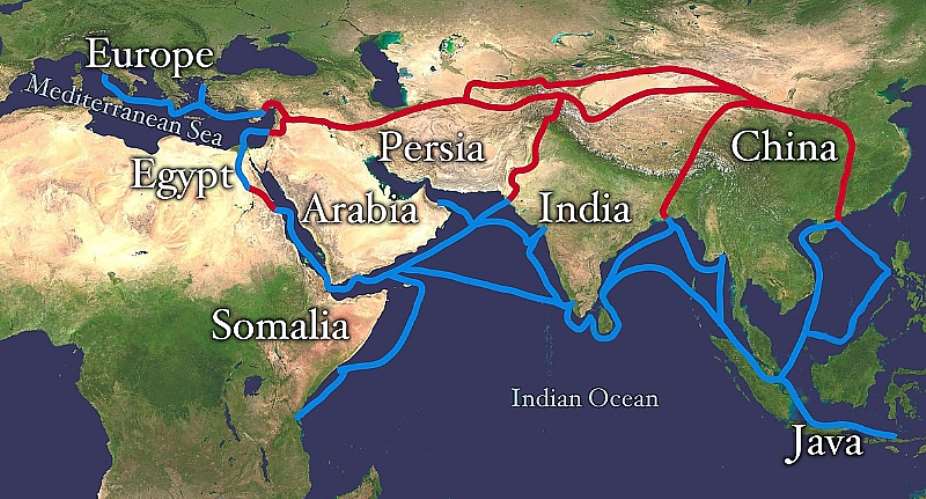
For my purposes, “India” will generally attest the territory “Greater” India that was once Brit.-ruled. Otherwise this means what today are Pakistan, India, Bangladesh, Sri Lanka (= Lanka, Taprobane, Serendib, Ceylon, etc) and just possibly, Myanmar/Burma.
Inside this vast region, the most followed religion is Hinduism. Given that it seems to incorporate the very name of India, it would be expected this indicates the actual birthplace of Hinduism. However, when Jayasree Suranathan (1) is brought up online, we find an attribution of Hinduism to the flooded lands to the south of what is now called Indonesia or what has been labelled as Sundaland.
Also from within this area came stories reaching Europe of sailors from Taprobane using birds as navigational aids according to Pliny (1st c. CE). Pliny puts this down to a lack there of science and in this light is Khobaragade Jamandas (2) asking online “Why Science Declined in Ancient India?” For him, the answer was apparently a resurgence of Hinduism that would appear to have occurred around the time of Hinduism was being codified as Manusmriti (= Laws of Manu) of ca. 500 BCE (?).
15
One of these Laws is that banning Brahmins from sea-travel. Another application of Hinduism seems to be shown by a passage from the Yuktikalpatara (= YKT) quoted on Sushama Londhe’s Tribute to Hinduism (= TTH) site. In it, Bhoja Paramara (11th c. CE) tells Indian shipbuilders not use nails to hold planks together. As this is further attested further west on the Red Sea, it may be this too is another case of a religious veneer put on a long-known practice. This practice is that of the “sewn-ship” tradition further attested by ancient texts still echoing down through the several millennia in and gathered together in King Bhoja’s YKT (3).
The Hindu caste-system did not just judge metals but also the timber used by Indian shipbuilders. This led one contributor to the IndiaNetZone (= INZ) to write of “irrational twaddle …leading to weakly-built ships that could not undertake long voyages”. Messrs. Athiyaman (4) and McGrail (5) drew attention to Tamil kalam (= kulla?) and shangadam they equate with the sangara described in the Periplus Maris Erythraei (= Voyage on the Erythraean Sea) respectively.
The sangara of the Erythraean Sea (= western Indian Ocean) closely relates to the jangada on the far side of the Atlantic on the Brazilian coast. However, these Tamil words indicate tied-log rafts and it is surely legitimate to wonder if such rafts would survive the ferocious seas of the Agulhas Current en route to west Africa and/or the far side of the Atlantic.
The TTH site further adverts to views of Asuras as Assyrians, Pani as Phoenicians, Cholas as Chaldaeans, etc. it may be seriously doubted whether so proud a people as the Assyrians would have been very thrilled at efforts to attribute their forebears to the Asuras who are best known as demons in India. As to the Cholas as ancestral to the Chaldeans of Babylon far to the west of India, the Chola were mainly of eastern parts of India facing the Bay of Bengal. Furthermore is that the great Chola floruit occurred several centuries after the Chaldean heyday. Outside of India, Chola exploits are to the east of India, not to its west.
Phoenicians are generally classified as Semitic; recent DNA research cited by Daniel Natal (6) and others evidently demonstrates that Phoenician antecedents are basically Pre-Semitic. In any case, the Phoenicians as Panis runs into the difficulty that the Panis are especially notorious as thieves in the epics of ancient India. Some Pacific islands may be relevant here, as when Spaniards got there, the islanders stole things (7). The Spaniards gave them plus the islands the name of Ladrones (= thieves). However, when the islands became officially Spanish, suddenly the Ladrones became the Marianas (after Queen Mariana).
Something else that is not confined to India is what might be called over- enthusiastic interpretations. In this light would be the vimanas referred to Indian epics and Egyptocentrics supposedly identifying certain depicting hieroglyphs aircraft. The Sipan (Peru) coffin-lid said to depict an Amerind chief on a space-scooter (8) and Catherine Acholonu’s Before Adam series (9) attaching Igbo/Ibo myth (re. UFOs?) adds more to this. More comes from Celto/Irish texts describing the flying wheel of the Irish Druid called Mogh Ruith and the “cigar-shape” (??) reported in the “Vita Columbae” by Adomnan (7th c. CE Irish). All can quickly and safely be set aside.
16
Radha Kumud Mookerjee (10) wrote a pioneering study of ancient Indian maritime history, This clearly differs from Robert Dick-Read (11) writing there was no such history. Mookerjee’s (ib.) reference to giant Indian ships can probably be placed alongside those of Part One and with the objects described just above as prehistoric aircraft that equally just above have been seen as due to over-enthusiastic interpretations. Their mythical nature is surely underlined by Mookerjee and others pointing that his reference is to the Ramayana which is a myth.
Another Indian writer was seen to have referred to weakly-built Indian ships that would be unable to go on long sea-voyages. This presumably would rule out the suggested Indian ancestry for such Amerind cultures as the Olmecs. The more so as India-to-the Americas voyages would involve more than 8000 miles. Even if lessened by leaving from some point in southeast Asia, the intervening vast Pacific and something like ca. 7000 miles of open sea would still have faced our putative Indian sailors. Making this even more unlikely would be that the Olmec heartland is in east not west Mexico and faces the Atlantic not the Pacific.
Other differences of opinion concern what is said by messrs. Rao (12) and Leshnik (13) about the claimed world’s earliest port at Lothal. Interestingly, the author of Ports of India: The Oldest Seven” (online) lists Lothal but makes Kolkata/Calcutta the oldest Indian port. However, it does appear that Shikaripura Rao (ib.) represents the prevailing Indian opinion on this matter. Lawrence Leshnik (ib.) does so for a sizeable non-Indian viewpoint arguing the Lothal harbour is no more than a water-tank on a large scale.
Rao (14) was also the lead investigator into a site off the Indian coast having various spellings. This is one of two known instances of what are known as “drowned lands”. One example is the above-noted Sundaland but those off Indian shores include Kumari in the southeast plus that having the several spellings of Darka, Dvaraka, Dawarka, etc. Given that Rao attributes the latter to Krishna and how integral this god is to Hinduism, this has to be wondered at the light of the Sundaland or “Indonesian” origin seen to have been claimed by Suranathan (ib.).
An island also of Indonesia or Island Southeast Asia (= ISEA) is Java. Mookerjee (ib.) cites a ship en-route between 5th c. CE India and China and was carrying the Chinese philosopher called Faxian (= Fa-Hsien/Fa-hien). Mookerjee (ib.) compared what for my purposes was the Faxian ship and those described by Nicolo Conti (15th c. Italian) for the need for lifesaving lifeboats attached to the main vessel. We are not told the Faxian had the compartments of Conti’s description allowing for a destroyed compartment not meaning the whole ship sunk. However, Faxian surviving his ship foundering on Java may indicate this feature.
A point to be borne in mind is that the ships described by Faxien/Fa-Shien and Conti were Indian and that lifeboats were needed carry their own implications. Nor were badly constructed Indian ships with a tendency to sink were not confined to those going east on to the Pacific. This also comes much nearer to home on the basis of the many legends cited by Mookerjee (ib.) as to wrecked Indian ships on presumably the Indian Ocean. Further is Alfred Grandidier cited by John Kent (15) as saying there were several Indian wrecks in the approaches to Madagascar (= Dvipa Mahal? [= the Great Island?).
17
Robert Gayre (16) notes Socotra as an island at the mouth of the Red Sea with Indians living there and more on the east African coast. Alongside this is Bharat (an old name for India) echoed by Eborata (between the east coast & the Great Lakes?), Lake Amara (= Lake Tanganyika?), Amara (nr. Lake Victoria?). To the east was land known as Chandristan (Sanskrit), Oros Selene (Greek), Montes Lunae (Latin), etc. Yet much of this is based on a map held to have aided Speke finding the Nile source but Suniti Chatterji (17) shows this is all based on a fake map.
For: Going East
Having once again played devil’s advocate, it remains to discuss what may be the more positive. Some things need to be done immediately. One is to point out that Dick-Read’s (ib.) complete dismissal of a maritime history for ancient India is completely wrong. Another is that it is facets only that are being touched on here.
Brian Sykes (18) is one of those marrying folklore with genetics and argued the following. In that part of Greater India now called northwest Pakistan, Hazara oral-lore of a Mongol ancestry is confirmed by genetics. Far away is that part of the oldest native literature of west Europe called Lebor Gabala Erenn (= Book of the Conquest of Ireland [7th c. CE]) doing likewise. Sykes (ib.) also refers to an African strain at Stornoway (Lewis) opposite the Callanish stone circle that Lewis folklore has it was constructed by Africans.
In this light is the TTH map showing the eastern side of India faces the Parva Samudra (= Sea of Samudra [= Bay of Bengal]) and going further east still brings us to Nusantara (= the Islands) otherwise called mainly called Indonesia translating into English as the Indianised Islands. We might also say this was also the homeland of the tongues collectively grouped as Austronesian of both the Indo/Malay and Polynesian groupings. If dates of ca.1500/1000 BCE for the oldest versions of such Indian epics as Mahabarata, Ramayana, Rigveda, etc, hold, there is mention of Varuna and of Rama seeking Sita (his wife) in these islands.
This presumably tells of Indian knowledge of Island Southeast Asia (= ISEA). As would mention of Varuna and who according to Erica Goy (19) was once king of the Hindu gods but reduced in status to the Hindu god of the sea. Other online sites have it Varuna became Baruna/Barunha in Indo/Malay and that this also lies behind the island-name of Borneo, Brunei (part of Borneo), etc.
Other names of suggested Indian origin for Borneo are not just Dvipa Varuna/Baruna but also Dvipa Saka (= Island of Teak? [Trees?]). Among yet more such names in ISEA are Dvipa Suvarna (= Island of Gold [= Sumatra]), Dvipa Jawa/Java (= Island of Barley or Grain [= Java]), etc.
Elsdon Best (20) is one of those citing “Uru” as west of India but recent DNA work makes those wanting Uru to be India or Australia much stronger. Best held the word of yawa/yava (= barley) from the ancient Indian language of Sanskrit became applied to Java. He was also of the opinion those earlier had it right when they stated this took on the secondary meaning that was the origin of the Polynesian concept of Hawaiki.
18
In the Polynesian islands Hawaiki is expressed variously. This includes Havaiki (Society Islands), Avaiki (Cook Islands), Hawaii (in north Polynesia), Savai (Samoa), Havai (in middle Polynesia), Hiva (Marquesas), etc, with an apparent meaning of Homeland. Elsdon Best’s major work touches on what he says was the Sanskrit word of vrihi (= rice).
He says this became wari, vari, pari in Polynesian. Also in the Polynesian spoken in the Rarotonga Islands it was as part of Hawaiki-te-varinga. Best says the Polynesian language of Maori in New Zealand lacks a v and that vrihi occurs there as iri. Best further wrote this explains how Vrihia (= India?) became Irihia in Maori and says Vrihia was regarded as an original homeland. It is probably here that belongs the so-called Tamil bell found in New Zealand.
That the Indonesian islands were once part of the drowned land now called Sundaland has been touched on. As was the suggestion here was the birthplace of Hinduism. On the other hand, it does appear more likely Hinduism originated in the place usually seen as its birthplace. This is equally so for what may be the offshoots of Hinduism called Jainism plus Buddhism.
Hinduism emerging in India is the generally accepted norm and in ISEA was the subject of “Hinduism in Indonesia” (21). The latter says there are several theories about how the religion was brought to these islands and were part of what led to the label of Indonesia or Indianised Isles. Transmission via the Kshatryas/Shatrias (= Warriors) is possible and to judge from ISEA temple-art, the military were always part of the overall set-up. Soldiers staying behind is exampled far to the west when Herodotus (5th c. BCE Greek) wrote of Africans staying in Georgia after “Sesostris” of Egypt left. A closer analogy is (?) the introduction is Islam to the ISAE island of Java said to figure members of Zheng-He’s soldiery who also chose to stay (22).
It would appear that what finally reached ISEA/Indonesia is Hinduism heavily tinged with Buddhism. It is also apparent that outside India, Buddhism came to prevail but that the Indian connection was never entirely severed. In his slim book on “India & Ethiopia”, Suniti Chatterji (ib.) cites Sir Charles Elliott describing Buddhism as the “export form of Hinduism”.
. The path taken seems shown by an article with a less than snappy title. So “Land Route or Sea Route: Commentary on the Paths of Transmission & Areas in which Buddhism was disseminated during the Han Period” is by Rong Xinjiang. It is translated by Xingui Zhou (23). There the transmission of Buddhism from India to China is said to progress overland by the 1st c. BCE but overseas by the 5th c. CE
Lewis Lancaster (24) discussed the overland and overseas routes and the difficulties that come with both. Those attaching to overland include the highest mountain range in the world, some of the world’s largest rivers draining these slopes, interior areas among the hottest and driest in the world, etc. Among those associated with the sea-routes are long coastlines, dangerous and uncertain weather and an inability to calculate longitude.
19
Having weighed up these problems, Lancaster (ib.) plumped for what he called the “rim of the (Buddhist) circle”. By this meant is the sea-coast of round the shores of east-to-south Asia from Korea to India. However, if connecting with a maritime spread of Buddhism from India to China, Korea plus Japan, this would not have been the first such contact if authorities cited by Londe (ib.) are correct. Londe’s authorities on this point are messrs. Philips (25) and Lacouperie (26). They cite accounts of ships having bird-headed stems linked to a placename coming directly from the ancient Indian language of Sanskrit.
This Sanskrit placename is that of Lanka (the island just south of continental India) is echoed as a placename in east China and in turn recognised as the base of Indian traders there by 700/650 BCE. Placed against Buddhism coming from India to China this gives an interesting background for such as ships with near-watertight compartments. The importance of this place is even more emphasised when we read it became the main base of the German Imperial Pacific fleet in Pre-1914 days
For: Going West (To East Africa)
Having seen the suggestion the word of yawa/yava from the Sanskrit language of ancient India was apparently transformed into a Polynesian word meaning homeland, it was noted there was an overlap with use of dvipa. Of particular interest is that both combine in the name of Dvipa Jawa/Java for the Indonesian island of Java and Dvipa Suvarna is now Sumatra itself possibly arising from samudra (= sea) with an apparently tentative meaning island of the sea.
On the other hand, dvipa applies to yet more islands of the sea but this time rather more to the west of India. Prominent here would be Dvipa Siele or Island of Lions (or Warriors = Ceylon/Sri Lanka). Also on the list are Dvipa Lakshad or 100,000 Islands (= Laccadives), Dvipa Mal as possible Garland of Islands (= Maldives), Dvipa Mahad or Mahal as possible Great Island (= Madagascar?), Dvipa Sukhadra or Isle of Bliss (Socotra), Dvipa/Dipa/Diba or (Wa)diba (= Bajun Islands?).
Whether the Indian term of dvipa or its slightly different spellings of dipa or diba used of islands seen right across the Indian Ocean leads to confusion is uncertain. However, the confusion of the islands of southeast Asia and east Africa noticed by Neville Chittick (27), Cyril Hromnik (28), etc. This is despite constant plying of seacraft across the same ocean. Much the same applies to islands off west Africa and the Caribbean that on some maps by Arabs and early Europeans are run together.
An early maritime entity of “Greater India” as what has been severally called the Harappan, Indus River, Indus Sarasvasti, etc, Culture. This culture covers much of what is now Pakistan and northwest India and has long been identified with the territory of Meluhha of ancient texts. The summarising of evidence by Gregory Possehl (29) shows the Harappans/Meluhhans in Sumeria at the head of the Persian Gulf, Dilmun (= Bahrein) in mid-Gulf east Arabia plus Magan (= Oman?) at the southern end of the Arabian Peninsula. Manthan Shah (30) wrote of Mesopotamian graves at Lothal (Gujerat, India).
20
This tells for Harappans the length of the Persian Gulf. An inscription showing the need for a Harappan interpreter in Sumeria (= sth. Mesopotamia [= sth. Iraq]) hints at Harappans settled there. Possehl (ib.) plus others suggest the amount of Harappan pottery at Ras al-Hinz (Magan/Oman) may indicate the same in Oman/Magan.
This can be put at near the beginning of any hints of navigation plus its sister sciences of cartography plus mathematics in India. On the other hand, the absence of scientific knowledge in ancient “India” was seen to have been stated very plainly in one case and to this we added the Plinian comment about the evidence for this in the part of “India” we saw as Ceylon or as the more up to date, Sri Lanka.
It has certainly been noted by the excavators at what has been called the oldest port in the world that the inhabitants of Lothal had a very high knowledge of what happens about the effects of the sea. The more so given its location at the head of the Gulf of Khambait/Cambay itself prompting a significant comparison made by Balasubramian Arunachalam (31) to be seen in “Tradition & Archaeology: Maritime Contacts in the Indian Ocean”.
Combining messrs. Mookerjee (ib.), Tripathi (ib.), Arunachalam, etc, bring other significant matters. Arunachalam’s “Traditional Sea & Sky Wisdom of Indian Seamen & practical application” refers to the simple devices usually labelled as wind-roses. Belonging here may be birds also having a navigational function. The comment by Pliny about this relating to ancient Ceylon/Sri Lanka was above-noted. This seems unknown in China and is but only one factor in ancient Indo/Sino relations. Others emerge from the Wikipedia entries on the paintings on the walls of Ajanta Caves and the Cholas touching on such as sails, compartmented ships, etc.
Among those describing the Ajanta cave-art is Alok Tripathi (32) in “The Antiquity of Sailing Ships on the Indian Ocean: Evidence from ancient Indian art”. Indian ships and claimed Chinese influence was touched on in connection with ships having compartments and/or lifeboats. More of the same comes with the suggested Chinese sails of a three-masted ship painted at Cave 10 at Ajanta. However, ships with lifeboats, compartments stopping damaged ships at sea being totally destroyed, birds in the role of navigational aids, etc, emerge as something very practical in early seafaring. Nor do writers from Mookerjee to Tripathi allow for the oblong sails of the Cave 10 ship.
Birds fluttering close to a vessel are depicted on a baked-clay amulet from the Harappan Culture site of Mohenjo-daro according to Paul Johnstone (ib.). Mookerjee (ib.) wrote that birds in such contexts is a norm for attesting ships at sea in ancient Indian art. Tripathi confirms this but further alludes to the birds in their navigational role also drawn to our attention by James Hornell (33). For Hornell (ib.) this is further known in India as the dishakak of Buddhist tales of Jataka type and certain Hindu texts.
As to judging the science of the Indian Ocean island of Ceylon/Sri Lanka by birds in this role, it will be probably be the case that had Pliny known of ancient Sri Lankan hydraulic civilisation he would have not have written so. In this light are Tibbetts (34) plus Hromnik (35 ib.) showing the Indian sources of the pilot-guides Persians, Arabs, etc, when they crossed the Indian Ocean. Such as Sanghi (36), Ganzhorn (37), etc, wrote of further evidence of movements at sea shown by small mammals.
21
It has long been recognised that rats in the form of Rattus exulans (= Pacific rat) was taken to all the Pacific islands by Polynesian migrants, even to that lonely of land called Easter Island. We have seen the probability that Rattus rattus (= black rat) was carried in Viking ships to Canada. Black rats join house mouse plus Asian house shrew in generally being given Indian origins and being found on Madagascar. Here reference to other islands also reached by small mammals is very relevant.
That background refers us to just how frequently these small mammals were carried in seacraft to these various islands. The voyages made were purposeful, the carrying of the small mammals unwittingly. This should serve to attest Indian ships acted as the unwitting transport for such as black rat to Madagascar. Some confirmation of this may come with the reference to blood-groups dominant in India and apparently to be seen among the variously called Hova or Merina of the Malagasy who became the rulers of both the Malagasy plus non-Malagasy races of Madagascar
Certain things can ruled out at this juncture. One is the several Indian wrecks described by Grandidier according to Kent (ib.) can be dismissed again according to Kent. It cannot be said there were no Indian wrecks but are not attested on this view. Also to be removed are claims that structures of east Africa from the Pyramids of Egypt to Zimbabwe types of much of east Africa south of the Horn of Africa are not to be attributed to Indian or any other non-African source.
Very definitely of Indian origin was the survivor of a particular shipwreck reported by Strabo (1st c. BCE Greek). Connected with this is a story contained in the Periplus Maris Erythraei (= PME) or Voyage on the Erythraean Sea written by an unknown Greek of the 1st c. CE. It tells us that someone called Hippalus discovered the monsoon route(s) across the Indian Ocean. Sean McGrail (38) points out that this individual did not exist and that what is at work is that a wind the Greeks knew as the hippalum was turned into a person.
From Strabo we learn that what is really the case is that our wrecked Indian was rescued and brought to the Egyptian court. In return, the Indian sailor taught a Greek named Eudoxus (3rd c. BCE?) how to utilise the monsoons. The importance of this line of navigation is that year-long coast-hugging was replaced by a more direct run from east Africa to India across the Indian Ocean taking approximately three weeks.
This Indian was not the only one acting as navigator for non-Indians if James Hornell (ib.) is correct. Hornell was the great British authority on maritime history for the earlier 20th c. What can only be described as his unfortunate comments about Africans has to set against the enormous amount of work he did rescuing archaic nautical traditions before they vanished forever.
Perhaps surprisingly, Hornell does not figure in the Keswani article on “Indian cultural & commercial influences in the Indian Ocean from Africa & Madagascar to South-East Africa” (38). Nor does his name appear in the references to her article. However, they do agree on what Keswani described as Indian impetus for Javanese enterprise. Hornell referred to not just Javanese but describes Indonesians more generally, so is referring to Indians navigating the seacraft of a people themselves having a very considerable maritime reputation themselves.
22
Another people having rather more of a maritime history than some have supposed are the Egyptians. There was always their reputation allotted to Egyptians on the Mediterranean by Greeks but the excavations at Saww/Mersa Gawassis (Eg.) considerably adds to the Egyptian presence on the Red Sea. This also does much to remove any need to looking away from east Africa for the location of Punt.
The stretch of east Africa that is most likely to be Punt extends along the coasts of Eritrea (once that of Eth.) through Djibouti to north Somalia. How far we might take the legends compiled for such as Kebra Negast about such as Makeda (= Queen of Sheba?), Menelik (her son) and those about General Ganges (whose Indian conquests gives the Ind. river-name) is left to others to mull over.
However, quite why Axum-ruled Ethiopia provides “The problem of ancient Africans in the Indian Ocean” that Yuri Khobanischow (39) describes is not immediately obvious. The Axumite Empire was certainly capable of mounting amphibious operations and Prabo Mihindukulasuriya (40) wrote of “Another ancient Christian presence in Sri Lanka: the Ethiopians of Axum”. Richard Pankhurst (41) wrote of a shared megalithic culture in the Naga Hills (Ind.) and Gurageland (Eth.) and similar development of Brahmi & Kharoshi (Ind.) and Ge’ez (Eth.) scripts. Pankhurst (ib.) further adverts to such comparable items as foods as curry (Ind.) and barbare (Eth.) and dress as sari (Ind.) and shamma (Eth.).
Indian ships not coming direct to east Africa would probably have come via the Maldives, Hormuz, Yemen, Aden, Opone and/or Socotra to Ethiopia. Of some importance here should be the offshore islands of east Africa. Cape Comorin (Ind.) seems mirrored in Comoro (islands off Madagascar) and the Sanskrit dvipa seems echoed in the slightly Africanised spelling of Wadiba for the Bajuns (islands off Somalia). The story was seen above that ANs were supposedly shipwrecked here but that was riddled with problems. More likely is dvipa/dipa had the African wa/ba prefix affixed to it (as Ba-ntu =Mankind) to become Wa-diba. Indian finds were excavated by Felix Chami (42) with some dated to ca. 2000 BCE by Chami.
It will be no great surprise much of this is mired in controversy, as it does to the famous Puranic/Hindu or “Wilsford” Map. Various works on this regard Bharat (an anc. name for Ind.) as echoed by Eborata (a territory between the east coast & the Great Lakes?). In like vein would seem to be Lake Amara (= Lake Victoria?) plus another place called Amara alongside a long lake that could be Lake Tanganyika. Belonging here too may be Chandristan.
Chatterji (ib.) does refer to Francis Wilsford having been given data by an Indian scholar but he found out this was fake and this is Chatterji’s stance on the matter. Yet Chandristan (Sanskrit), Oros Selene (Greek), Montes Lunae (Latin), etc, not only all translate as Land/Mountains of the Moon but also apply to the mountains usually identified as the Ruwenzoris (on the Uganda/Congo border). If the Greco/Latin designations stand, there seems no valid reason why that in Sanskrit does not. Also to be borne in mind is that years after Wilsford’s time, John Speke strongly held the “Hindu” Map greatly aided him in becoming the first European to find the source of the River Nile. Parineeta Dandekar (43) says Krishna (= an Ind. god-name) was used of Indian rivers and is known to apply to the Nile as a sacred river.
23
India, Africa, The Sea & Antiquity (Pt. 4)
Likewise known in Egypt is “The Tale of Half-drowned Sailor”. It has been touched on already but a point not oft-shown is that the “Sailor” was Indian and piloted the first known European to cross the IOR (as Strabo). Of the Indian Ocean region (= IOR) were Indians navigating ANs across that ocean (as Hornell 1934). Among Indian ship-types is the musum-baza (= monsoon-boats) to further attest Indian expertise and may part-name Mozambique (as Hromnik).
Another spelling of the latter name is Mocambique that like Mombasa (Kenya) may mean Place of Boats. Mozambique also occurs as part of the Mozambique Channel separating Mozambique and Madagascar. The dangers of crossing this waterway were known to Europe as far back as Marco Polo (13th c.). However, the Portuguese as the first Europeans on the IOR could not cope with these dangers to the degree that their own law banned Portuguese crews from entering the Channel.
Problems result from the squeeze of waters from the Mozambique Current leading on to the Agulhas Current. There is a comparison of water boiling in a cauldron and the seas around Cape Agulhas, hence an alternative term of Cape Cauldron. Arunachalan (ib.) made another telling comparison. It was seen Villiers (ib.) compared Phoenician ships going across the Bay of Biscay with those rounding Cape Agulhas. That by Arunachalan was of the conditions of the Gulf of Khambait/Cambay and those of the Agulhas “Cauldron”.
Shared by the Bay of Biscay, the Gulf of Khambait plus the Agulhas Current is the very sudden rise of ferocious conditions without prior warning. Cape Agulhas is the southernmost point of Africa, not the Cape of Good Hope. A salient feature of Cape Agulhas is that to its east is the Indian Ocean and to its west is the Atlantic.
This dividing of the seas was known to Indians as Kumari Duab (= Parting of the Seas/Waters) according to Hromnik (ib.). The southernmost point of India is another land’-send terminating in a triangular point called Cape Comorin, as does Cape Agulhas. On this line, both Cape Comorin and Cape Agulhas share variants of the Indian term of Kumari. There are a number of traits said to be of Indian origin in west-facing parts of southern Africa that will be touched on shortly and which Bernard Sergent (44) says could only have come by sea.
For: Going West (To West Africa)
Much of southern Africa was once populated by people usually called the San but as Khwe (as above) and Queyna by Hromnik (ib.). Across this spread are such items as what are generally regarded as digging-sticks attaching to early stages of crop-raising plus scenes painted on rocks. What may be digging-sticks are regarded by Hromnik as vulva-like images of Yoni type closely associated with the Hindu god called Shiva. Hromnik also wrote the light two-wheeled chariot as also closely linked to Shiva/Siva in India and holds that it is echoed in a piece of Khwe rock-art. He also shows that in India Shiva is closely associated with use of the triple bow and that another scene of Khwe/Queyna rock-art shows Shiva as the Khwe god named Heitsi Eibib and the depicting of the triple bow.
24
Sergent (ib.) says yet another form of bow is relevant. This is what he refers to as the scraped musical bow. He says that in the Ganges Plain (India) it is not part of any Indo/Aryan heritage and is more inclined to put to Dravido/Tamil sources. Sergent wrote that it occurs in Africa among the non-Bantu Khwe that he calls Boschimens (= Bushmen) plus the Bantu-speaking Thonga, Zulus, Tenda and the Kiaba who are an ethnia of the mouth of the Congo.
The Munda are seen by Sergent originating east of India but as very early settlers in India. He says the Saora are Munda but radically differ from the others, especially in terms of religio/cultic under strong Dravido/Tamil influences in turn compare right across Africa. Messrs Ross & Ibbotson’s “Glossary of Tribes & Castes …” (44) add the Braivargi leopard cult of India and Vicky Van Bockhaven (2013) wrote of “The Leopard Men of Eastern Congo”.
India as possibly where compartmented watercraft first appeared was mentioned above and presumably relates to the Bamanga canoes also having compartments and Robert Dick-Read (45) says they were/are widely sold in the DRC. Many in India object to the notion of Brahmins ceasing to be Hindu priests when going on voyages. On the other hand, analogies widespread outside India are made obvious by Hornell (1946). He cites Plutarch (c. CE Greek) and Porphyry ( c. CE Greek) saying Egyptian priests also objected to going to sea. Porphyry particularly states Egyptian priests had to undergo strenuous purification on this count. Whitridge Northcote Thomas (46) adds that on the other side of Africa yet more African priests attest another version of this belief.
This involves the orhene (= priests) of the Igbo/Ibo of Nigeria being forbidden to travel in watercraft. The Wikipedia article on the Igbo tells us the Pre-Igbo pottery at Nsukka (Nigeria) has good Igbo affinities. The suggested 3000/2500 BCE stands close to some based by Catherine Acholonu on external comparisons. However, the Pre-Igbo/Igbo being known in their part of Nigeria for more than 4000 years plus quasi-republicanism as the best known feature of Igbo governance.
The quasi-republicanism is nicely summed up in the Igbo/Ibo maxim of “Igbo enwegh eze” (= Igbos have no king). This being so, the individual or Eze Nri revealed by Thurstan Shaw (47) as having been buried in a vault titled Igbo-Jonah at Igbo-Ukwu (Nigeria) is demonstrated to somewhat run counter to the general Igbo tradition.
Shaw (ib.) dated the three sites at Igbo-Ukwu at ca. 900 CE but this also runs counter to other Nigerian opinions. One of them is Babatunde Lawal who introduces “Dating Problems at Igbo-Ukwu” (48) and Catherine Acholonu’s “Before Adam” series also challenges Shaw’s conclusions as to dates at the same sites.
Given it is seen the Igbo had no king(s), the elaboration revealed by the Igbo-Jonah burial becomes even more anomalous. So too does the bronze-work made by the cire perdue (= lost wax) process, as it seems lost-wax bronze-work seems unknown elsewhere in Nigeria. Of interest here is the term of Ethiopian. It was the most common Greek word for very dark-skinned population(s) stretching from Africa to India. On the far west of what the Greeks deemed to be western Ethiopians are what much later writers described as the true Negroes. What becomes relevant here is a much-shown figurine from Mohenjo-daro known as the Dancing-girl.
25
This figurine depicts a “true” Negro and is of the cire-perdue bronze-work prominent in the Indian Chalcolithic, as at Mohenjo-daro. In this light are comparisons of Indian Shiva and Nigerian Eze-Eri (= King? Eri) adorned with arm-bands, bracelets, anklets, masses of beads, metal staff, animal horn, leopard, many snake motifs, woven cloth, etc. Metal bells, talking (?) drums, elaborate metalwork, equally elaborate pottery, etc, connect Shiva of India and the Yorubas plus Igbos according to Acholonu.
They are underlined by objects associated with the Hindu god named Krishna known to be one of the Indian words meaning black. Among them are the feathered crown of Krishna and those of the initiates of the Ozo cult of the Igbos. The conch shell of Krishna has elaborate model copies at Igbo-Ukwu. The flute of Krishna mirrors that of the Igbo Oja (= flute of the Goddess). The Indian epic bearing the title of the Mahabarata has Krishna dancing in the manner of the Igbo Mponkiti.
Vishnu is the third member of a Hindu trinity of Shiva, Krishna plus Vishnu. He had a peacock attribute matched by that of an Eze (= chief) of the Igbos of Anambra State (southeast Nigeria). Acholonu opined that the serpents associated with Vishnu are echoed on items from Igbo-Ukwu and also that these serpentiforms unite both these items and the Ikom stones. There are what may be Indian-style elephant heads, ornately-beaded pottery plus the innumerable found at Igbo-Ukwu.
The caste system of India officially does not exist and that of any part of Nigeria is held to not to exist. It will be obvious the former still exists under the various labels of Dalit, Untouchables, Sudroids (oft-called Indian Negroids), etc. Yorubaland parts of Nigeria also have their castes according to Tim Curry (49) but when Nigerians use the term of Osu, we are mindful this is Igboid not Yoruban. Such studies attest the low societal status of the Dalits of India and the Osus of Igboland (Nigeria).
The Dravido/Tamil medical system of ancient India called Ayurveda has some resemblance to the pronunciation of the ethnia called the Yoruba(s) who also inhabit part of south Nigeria. Tariq Sawandi (50) felt that the Ayurveda system closely resembles the Ifa Herbology of Yorubaland for words, their meanings, spellings plus methods. The city of Varanasi/Benares (India) is regarded as the holiest city of Hinduism in the way that Ile-Ife (Nigeria) is for the Ifa faith of the Yorubas.
Sergent (ib.) is one of a long list of authors calling attention to pallankulli anciently played in India. When the non-Indian kin of pallankulli is discussed, a connection with the Mesoamerican pachisi/parchisi is usually made. What this clearly overlooks is the related mancala, wari or awari is not just known in Africa but is so widespread there it is sometimes called the national sport of Africa. The African version(s) go under innumerable names, as nicely illustrated by that of awule by which this board-game is known to the Baule of that part of West-coast Africa that is Ivory Coast.
A possible Indian linkage for bronze-work in one part of west Africa takes us to that of another part also West-coast Africa. Leopold Senghor (51) was the first black president of Senegal with such tongues as Wolof, Bambara, etc. Xancara (= bronze) is a word from the Indian language of Telegu and xanjar (= bronze-working) is from Wolof. Telegu inumu (= iron) may give the numu (= forge) of Bambara. Telegu and Wolof both have kamara (= blacksmith’s caste)
27
Senghor (ib.) further drew attention to the word of ec from the Dravido/Tamil language of Pengo that he translated as meaning the carding of cotton. There is yet another very similar word from the language that is most dominant in Senegal that is Wolof. The Senghor equation of ec is Wolof eec applied to the producing of yarn from raw cotton. This has more of the simple musical instruments of noisemaker form joining what Sergent insists must indicate maritime connections.
More signs of these maritime connections are shown by islands to the east of India we have seen are dubbed as “Austronesia”, Island Southeast Asia (=ISEA) or Indonesia (= Indianised Islands). Indian ships here are shown by such as that taking Faxian back to China but it foundered in ISEA. Another but probably later wreck may be represented by what is called the Tamil bell found in New Zealand. Alongside is the probability of innumerable Indian ships that did not founder. Fitting here too are the dvipa, dipa and diba seen to apply islands extending across the Indian Ocean Region (= IOR) from ISEA to east Africa.
James Hornell (1934) shows more signs of path/route-finding by the Austronesian Indo/Malays across the IOR from ISEA to Madagascar. It was seen we are told in “The Tale of the Half-drowned Sailor”, this half-drowned seafarer was a survivor of a shipwreck on the Red Sea who wound up in Egypt. There he agreed to pilot Eudoxus across the IOR from the Red Sea to India. Salient here is that the Indo/Malay migrants (as Hornell) and the Greek Eudoxus (as Strabo) were led by Indians.
One of the dvipa-names applies to the Bajun Islands (off Somalia) in east Africa. Here too were the places identified by the Hindu Map. Probably most salient is the region called Chandristan that if correctly meaning Land of the Moon fits with the Greek Oros Selene and the Montes Lunae meaning Mountains of the Moon for same region. This Map also names adjacent areas as Amara employed for Lake Tanganyika and close to Lake Nyasa (= Lake Victoria). That there is considerable scepticism about this Map was shown above. Yet to be borne in mind is that is mind is that John Hanning Speke was adamant that it helped him to locate the source of the River Nile.
In this way Speke became the first European known to have achieved this, as Eudoxus became the first European to travel to India using the IOR monsoons. The 2nd c. BCE date for Eudoxus clearly antedates the PME claim for Hippalus doing so in the 1st c. CE, the more so given that Sean McGrail (52) shows “Hippalus” results from a Greek word for these winds garbled into a personal name. In this light is Hromnik (ib.) drawing attention to Indian expertise in respect of the IOR monsoon system by ships called musum-basa (= monsoon-boats). Not to be missed is the feats of Eudoxus and Speke were achieved via this Indian Expertise.
Musum-basa is a candidate for the etymology of the state-name of Mozambique and possibly also the name of Mocambique Island (= Place of Boats) off the coast of Mozambique. Here too belongs the name of the Mozambique Channel separating Mozambique and Madagascar. As early as the days of Marco Polo, it was regarded as nearly impossible to navigate this Channel. This prevented the Portuguese from doing so. They were forbidden to attempt to so by Portuguese law for the whole of the 16th c. Yet Indians doing so would appear to have coped well with these dangers.
28
Much of the danger arising from the approaches to this Channel is the way the sea is funnelled into a rush of water to where the Channel becomes the Agulhas Current. Here the sea is so like a pot of boiling water that it has been nicknamed Cape Cauldron. We saw Villiers (ib.) thought these conditions were comparable to those of the Bay of Biscay (off west Europe). Ibn Majid (15th c) is held to be the finest of Arab nautical writers and is cited by Arunachalam as seeing this as comparable to the Gulf of Khambait/Cambay
Just how dangerous these seas can be is well illustrated by the Waratah. This ship was a modern and well-built passenger liner that evidently went down off southeast Africa and the wreck has never been found. The loss of life was such that it has gained the unwanted title of the southern Titanic (53) and would parallel the Tek Sing (= the eastern Titanic) and the Titanic. On the other hand, it should have great interest as to the form of the other ships hypothesised to have successfully negotiated their way past Cape Agulhas.
The forms of seacraft deemed capable of coping with the dangers attaching to passing Cape Agulhas now become significant. Those bringing ANs west and held to have passed Agulhas and round to Atlantic-west Africa to may have been “proto-mitepe”. This is what is would be called for between 1000-500 BCE on the dates for ISEA- sourced bananas at Kang, elephantiasis at Nok, etc, yet mitepe were reputedly very leaky. Of 1000-500 BCE too would be Phoenico/Punics also navigating round Africa east/west (by Necho as Herodotus), west/east (Hanno as Pliny) and (Eudoxus-found as Strabo). However, Rawlinson (ib.) described Phoenico/Punic ships as frail and tiny and the Eudoxus-found remains were of a hippos held to be poor ships by Strabo.
Citing Hromnik again, India knew of Cape Agulhas as Kumari Duab denoting parting of the waters. This is because at this point the seas become the IOR to the east and the Atlantic to the west. On the arguments of Sergent plus others, Indians went passed this point. As seen in the just-above paragraph, the indicated dates in all liklihood tell for a period in which simple forms would predominate.
Staying with notions of simple seacraft, if the model found at Lothal is correctly rigged then it was a primitive sailing-ship. If so, getting from the proposed dockside at Lothal on to the open sea, would have been interesting. Or put in starker terms would have provided a not inconsiderable challenge. On this point, there is Arunachalam (ib.) citing ibn Majid (15th c.). We saw Majid is regarded as the best Arab writer on nautical matters and immediately pertinent is his comparison of conditions related to the Gulf of Khambait/Cambay and those of Cape Agulhas.
Two forms come immediately to mind that would presumably meet the criterion of having reached the shores of the Atlantic, albeit some rather surprising ones. One is the jangada known across the Atlantic in Brazil in northeast South America. The method of rigging plus the sail-form contrasts with those of European sailing-ships. Nor does jangada translating as tied-logs suggest anything similar to European ships or having the ability of surviving navigating past Cape Agulhas.
29
The most widely accepted view is the jangada is of Portuguese introduction to Brazil. Balsa and jangada are interchangeable on both the Pacific-facing and Atlantic-facing sides of South America and the Pacific and Brazilian forms are very forms are very similar surely tell against this. It would be curious that there would be an introduced term when there were perfectly good Amerind terms for these seacraft. On this count we might consider the Moroccan almady that was also a native word encountered by the Portuguese and was not just retained by them but extended to descriptions of other west African types. Not to be overlooked is jangada, shangadam, sangara, etc, are but variants of basic terms from the Indian language of Tamil.
Something that does tend to be overlooked is something arising from translations of al-Masudi (10th c. Arab) and al-Biruni (9th/10th cs. Persian) by Paul Lunde (54, 55). Masudi wrote of seacraft discovered on the Mediterranean island of Crete and Biruni a plank that had drifted to Crete. Lunde compared the account by Strabo of the wreck found by Eudoxus in east Africa with what was just seen to have been stated by Biruni. However, the fleet sponsored by Pharoah/King Necho of Egypt seemingly offers a closer parallel for the several ships described by Masudi.
The description of these vessels by Masudi, Biruni plus others was that they had been in the water for a long time. Also that they were constructed using what is technically known as the sewn/stitched plank method said by Masudi only known on the “Abyssinian Sea” (= western Indian Ocean). Another addition by Masudi is that they were of teak, therefore, were Indian-built. Thus it would appear Necho’s Phoenico/Punic fleet noted by Herodotus join with the Indian ships of the Masudi/Biruni accounts. This was that both Phoenico/Punics and Indians were deemed capable of having navigated round the whole of Africa.
References
1 Mystery of Mt. Toba (Sundaland) explained through the Puranas (25/11/2011)
2 Why Science declined in Ancient India (online in 2015)
3 King Bhoja (online in 2015)
4 Nautical Terms as Gleaned from Ancient Tamil Literature (online 2015)
5 Boats of the World (2005)
6 The Hitto-Phoenicians (Phoenicia org. 2006 [online 2017])
7 Marianas (Wikipedia in 2015)
8 Chariots of the Gods (1968)
9 Before Adam series (published between 2009-2012)
10 Indian Shipping …from earliest times (1912)
11 Phantom Voyagers (2005)
12 Lothal (Wikipedia in 2015)
13 American Anthropologist (1968)
14 The Lost City of Dvaraka (1991)
15 The Early Kingdoms of Madagascar (1970)
16 The Origins of the Zimbabwean Civilisation (1972)
17 India & Ethiopia (Asiatic Society Monographs No XV 1968)
18 The Blood of the Isles (2007)
19 Varuna: The Judgemental God (acc. 2017)
20 The Maori as He Was (1934)
30
21 Hinduism in Indonesia (Wikipedia acc. 2017)
22 Zheng-He (Wikipedia acc. 2017)
23 Sino Platonic Papers No 144 (2004)
24 Academia.edu. (acc. 2016)
25 Journal of the Royal Astronomical Association (165)
26 The Western Origins of Chinese Civilisation (1966)
27 In The African Iron Age (ed Peter Shinnie (1972)
28 Indo-Africa (1980)
29 In The Indian Ocean in Antiquity (ed. Julian Reade 1996)
30 Lothal: The Port & Hub of Ancient India (acc.2017)
31 The Seacraft of Prehistory (1980)
32 In Tradition & Archaeology… (edd. messrs Salles & Ray 1994)
33 Ziff Journal (2006)
34 Antiquity 1946)
35 Azania (2007)
36 Rat Migration & History Looks Different (acc. 2017)
37 Jorg Ganzhorn (in Animal Conservation 2003)
38 In Historical Relations Across the Indian Ocean (UNESCO 1974)
39 Journal of African History (1967)
34 Azania (2007)
35 Rat Migration & History Looks Different (online 2015)
36 Hingston et al
37 Boats of the World (2005)
38 In Historical Relations Across the Indian Ocean (UNESCO 1974)
39 Journal of African History 1967)
40 Another Ancient Christian Presence in Sri Lanka: The Ethiopians of Axum (Academia edu. 2015)
41 Ethiopia Across the Sea (online in 2015)
42 The Unity of African Ancient (2005)
43 Medieval Authors on East Africa (online 2015)
44 Tribes & Castes of the Punjab & Northwest Frontier (pub. between 1911-1919)
45 Phantom Voyagers (2005)
46 Journal of the Royal Anthropological Institute (1917)
47 Igbo-Ukwu: An Account of Archaeological Discoveries in Eastern Nigeria (1974)
48 Journal of African History (1967)
49 Study of Cult Systems of the Ibos of Nigeria & the Dalits (of India) (acc. 2017)
50 Yorubic Herbology: The Art of Divine Herbology (acc. 2017
51 African Origin of the Dravidians (acc.2017)
52 Boats of the World (2005)
53 SS Waratah (Wikipedia acc. 2017)
54 Monsoons, Mude & Gold (Aramco World 2005)
55 In the Penguin Great Journeys series (co-edited with Pauline Stone (2007)
Harry Bourne


 High Court clears NDC to enforce six-month resignation rule for appointees vying...
 CHRAJ debunks false social media claim linking Deputy Commissioner to Wontumi se...
 “Sanitation is not a municipal problem, it is a national security issue” —GAMA P...
 Prison is not a place I would wish for anyone" — Nana Agradaa on Chairman Wontum...
 'We won't praise you for this uninspiring, same old story' — Minority Leader on ...
 Mid-Year Review: 'Ghana's economy moved from emergency room to the wellness cent...
 Mid-Year Review: 'Economic recovery a result of superior economic management' — ...
 Mid-Year Budget Review: 'NDC inherited an economy on its knees' — Finance Minist...
 Mid-Year Budget Review: It has been excellent six months — Joe Jackson
 Wontumi's 20-year sentence is ridiculous, punishment for his criticism of NDC — ...

