
When Ghana declared independence in 1957, it inherited more than a flag and a constitution. It inherited a map, a railway map. And that map had already shaped the country’s economic geography for over half a century.
Railways are not neutral infrastructure. They determine which towns grow, which industries thrive, which ports dominate, and which regions remain peripheral. In the Gold Coast, colonial rail design was not built for national cohesion. It was engineered for extraction. And its imprint still influences Ghana’s economy today.
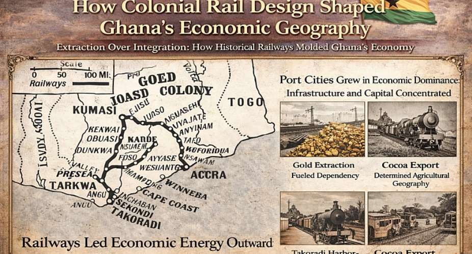
1. Railways Built for the Coast, Not the Continent
The earliest railway lines connected mineral and agricultural zones to the coast, not to each other. The Western Line linked Tarkwa and Obuasi’s gold fields to Takoradi Harbour. The Takoradi–Kumasi corridor moved cocoa and timber from Ashanti to the port. The Accra–Nsawam line tied agricultural areas to the colonial administrative capital.
Notice the pattern below?
Inland → Coast → Europe
There were few east–west connections and limited inter-regional integration. The goal was efficiency in exporting raw materials, not building a balanced domestic market network. This design created a coastal gravity. Economic energy flowed outward.
2. The Rise of Port Cities
Railways transformed Sekondi-Takoradi and Accra into powerful economic anchors. Takoradi Harbour, completed in 1928, became viable precisely because rail fed it minerals and cocoa. Without rail, it would have remained a modest coastal settlement. With rail, it became an export powerhouse. Similarly, Accra’s rail connection reinforced its political and commercial importance. The railway strengthened the capital’s administrative control over inland production zones.
The effect was structural: Port cities accumulated infrastructure, capital, and population faster than inland towns not on rail lines. Even today, Ghana’s coastal belt remains economically dominant, a pattern rooted in colonial logistics design.
3. The Mining Corridor Effect
Rail access determined mining viability. Gold mining in Obuasi and Tarkwa became globally competitive because rail drastically reduced transport costs. Bulk commodities like manganese and timber required heavy-haul capacity, something roads of that era could not provide.
But this also entrenched an export-oriented economic model. Mining towns grew around rail depots, but value addition rarely occurred locally. Processing industries were limited. Raw materials moved outward quickly. Rail infrastructure made extraction efficient, and dependency durable.
4. Cocoa and the Agricultural Axis
Cocoa became the backbone of the Gold Coast economy in the early 20th century. Railways accelerated its expansion by linking farming zones to ports. Farmers along rail corridors enjoyed better market access, lower transport costs, and faster export cycles. Areas off the rail network faced disadvantages.
Thus, railway alignment influenced agricultural geography. Production clustered near access points. Economic opportunity followed steel tracks. Even today, many major market towns correspond closely with historic rail stops.
5. Uneven Regional Development
Railways produce “corridor economies.” Communities on the line thrive. Communities off the line lag. Northern Ghana, largely excluded from the early rail network, did not benefit from the same level of colonial transport investment. As a result, economic concentration tilted southward.
This was not accidental. Colonial planners prioritized zones with export potential. Regions seen as less commercially strategic received less infrastructure. The consequences persist. Infrastructure gaps reinforce income gaps.
6. Road Dominance and Structural Continuity
After independence, Ghana invested heavily in road transport. Roads offered flexibility and broader reach than aging narrow-gauge rail lines. However, roads did not fundamentally alter the inherited economic geography. They often followed existing trade flows shaped by rail. Ports remained dominant. Mineral corridors remained central.
In other words, the economic skeleton established by colonial rail design continued to guide movement patterns, even when transport modes changed.
7. Industrialization Interrupted
A rail network designed for extraction is not automatically suited for industrialization.
Industrial economies require:
- Inter-city connectivity
- Efficient domestic freight exchange
- Integrated manufacturing corridors
- Balanced regional access
Ghana’s inherited network lacked strong lateral connections between production centers. It radiated toward ports rather than forming a national grid. This limited the rail system’s ability to stimulate diversified industrial growth after independence.
8. What This Means for Ghana Today
Understanding how colonial rail design shaped Ghana’s economic geography is not an academic exercise. It is strategic.
It explains:
- Why coastal cities dominate GDP
- Why mining corridors remain economically powerful
- Why some regions struggle with infrastructure deficits
- Why freight logistics still prioritize export routes
More importantly, it clarifies the task ahead. If colonial railways structured Ghana around extraction, modern rail policy must restructure it around integration.
9. Redesigning Economic Geography
True infrastructure independence requires intentional redesign.
Future rail strategy must consider:
- Connecting inland industrial parks to each other, not only to ports
- Expanding rail access toward underserved northern regions
- Integrating rail with inland water transport and dry ports
- Promoting value-added processing near production zones
- Embedding data-driven corridor management
Ghana does not need to erase its railway history. It needs to reinterpret it. The original rail lines were logical for their time. But Ghana’s economic ambition in 2026 is different from that of the Gold Coast in 1905.
Conclusion: Steel Tracks, Lasting Impact
Colonial rail design did more than move goods. It shaped cities, migration patterns, industrial zones, and regional inequalities. It determined where capital accumulated and where opportunity concentrated. The railway map became an economic map. As Ghana celebrates independence this month, it is worth remembering: political sovereignty began in 1957, but economic geography had been molded decades earlier.
The question for this generation is clear. Will Ghana allow inherited corridors to continue defining its future, or will it engineer new ones that reflect national integration, industrial ambition, and long-term sovereignty?
Infrastructure does not just move economies.
It shapes them.
Author: Joseph Fuseini ([email protected])

 How tipper truck killed UCC lecturer and his TA in their vehicle parked
 UCC TA killed alongside lecturer graduated as best student of Geography Departme...
 UCC mourns lecturer and teaching assistant killed in road crash
 NPP should be the last to speak on recent power crisis — Akwatia MP
 Our client will not retract gay allegations against Ntim Fordjour - Angel Maxine...
 Calls for Energy Minister's resignation baseless — Steve Manteaw
 President Mahama has not gagged free expression — Shamima Muslim
 Ghanaians wish Bawumia is currently the President — NPP communicator
 Fourth Akosombo unit restored as power recovery efforts intensify
 King Charles and Trump toast ties despite Iran tensions

