
Exactly 100 years ago, the largest volcanic eruption in the 20th Century blasted away for three days in a remote patch of southwest Alaska. The eruption blackened the skies over Kodiak, nearly 100 miles away, and covered the village in a quilt of ash two feet deep. Residents in Juneau, 750 miles away, heard the explosion an hour after it blasted. The eruption eventually tarnished brass in California and Colorado, and lowered the earth's average temperature that year by 2F.
Although the eruption was a century ago, one of its more visually astounding effects remains. In the middle of Katmai National Park and Preserve, a 6,395-sq-mile swatch of wilderness known mainly for its bear watching and salmon fishing, a wide, ash-covered valley is surrounded by steaming, snow-covered volcanic mountains and marked by a surprisingly small, yet several-story-high black mound. This mound is Novarupta (which means “new eruption”), a volcanic vent and the source of the massive 1912 eruption.
Intrepid hikers can explore the valley, while those less keen on the often-harsh conditions can enjoy the views from the Griggs Visitor Center, a tiny facility located at the end of the valley.
The 20th Century's biggest eruption
The eruption was so huge that it drained the magma from the area, causing the top of Mount Katmai to collapse, six miles away. When Robert Griggs of the US Geological Society (USGS) led an expedition to the area in 1916, he came across the otherworldly sight of a once-verdant valley covered in ash and peppered with thousands of steam jets. He named it the Valley of Ten Thousand Smokes -- and though there are no more hissing fumaroles, the sight of this grey valley in the middle of Alaska's lush summer greenery is no less awe-inspiring today.
On this same expedition, Griggs discovered the two-mile wide caldera of Mount Katmai and mistakenly identified it as the source of the eruption. It was not until 40 years later that researchers realized that the domed mound, now named Novarupta, is what actually blew. This steaming, squat black rock dome –- only 90m high and 1,185m wide -- is a new volcano, a previously undiscovered volcanic vent now plugged by a lava dome several stories high. Its small size makes it difficult to imagine that it caused one of the largest recorded volcanic eruptions in history.
The valley, which was never inhabited by humans, has always been an important traverse for animals travelling between Katmai Bay on Shekilof Strait and the salmon-filled Brook River . It is still common to see grizzlies or their prints, and nearby Brooks Falls is a world-renowned bear watching spot, where grizzlies perch on top of a small waterfall and snap up the salmon jumping upstream.
Trekking the valley
While thousands of visitors descend upon Brooks Camp (set at the mouth of the Brooks River near Brooks Falls) each summer, most only make a day trip to the Griggs Visitor Center. From here you can hike a mile to the tip of the valley at the ash flow's farthest reach, or to a raging waterfall at Three Forks Overlook, on the outer edge of the valley. But spending a few days in the Valley of Ten Thousand Smokes can be the trip of a lifetime.
A several-day trek is the best way to explore the valley. There are no official trails and at least two river crossings, depending on where you explore. Treks should not be undertaken by inexperienced hikers, and you should plan for inclement weather and tough terrain.
To reach the valley, catch the park bus ($52 each way) from Brooks Camp, which is in turn reached by air via Katmailand air service from either Anchorage, Alaska's largest city, or the town of King Salmon. Though the valley is only 23 miles from Brooks Camp, it takes an hour by bus up a bumpy dirt road to get there.
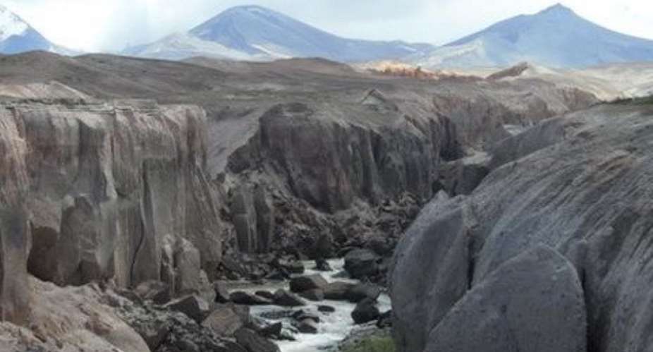
The bus drops hikers off about a mile from the Griggs Visitor's Center, at the Windy Creek trailhead. Hikers follow a small path through alder trees to Windy Creek, a silty creek that must be forded. It is best to take hiking poles (and a friend) for this one. Search out the best spot to cross, and continue until you find the unofficial trail into the valley, packed down by other hikers. Because there are no official routes, you will need a map and compass to get your bearings. You will also need to ford the Lethe River, which slices through the valley's ash in a deep, thin canyon.
 VIDEO: Ayanfuri Chief dies after testing potency of his juju at funeral
 Ashanti North Police interdict Inspector over defilement allegations
 Here are areas to face power outage over ECG planned maintenance today
 Ghana pushes for instant payment systems across Africa
 GAF to conduct Exercise Storm Shield 2026 in Bono and Upper East
 ECG resumes two key stalled projects in Kumasi
 Mahama breaks ground for Green City Housing Project at Dedesua near Kumasi
 Celebrating mothers: Honouring the Heart of the Ghanaian Society
 EOCO Boss Raymond Archer defends PDS investigation methods
 Snakes, weeds take over multi-million 1D1F starch factory at Kyekyewere in Assin...

