
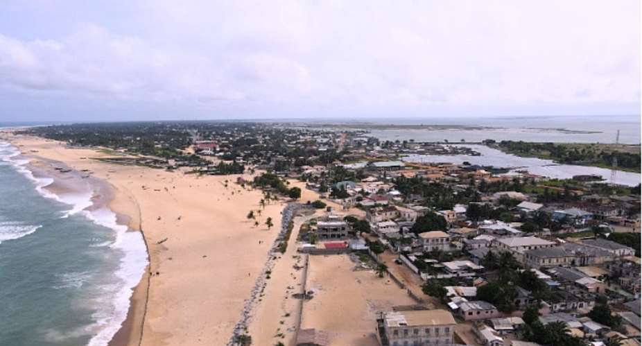
Ghana's coastline is undergoing rapid transformation due to coastal erosion, severely impacting local communities, ecosystems, and industries such as tourism and fishing. Leveraging advanced satellite data and geospatial tools to monitor shoreline shifts, researchers are now gaining deeper insights into the issue and developing innovative solutions to address these challenges.
Dr Patrick Nii Lante Lamptey, a lecturer at the Akenten Appiah Menka University of Skills Training and Entrepreneurial Development, leads a pioneering research initiative on behalf of the Ghana Science and Technology Institute (GSSTI). The objective is to assess the feasibility of using Digital Earth Africa’s Coastline Monitoring Service to track and mitigate erosion at Keta Lagoon and Cape Coast.
The real cost of erosion
Ghana’s eastern and central coasts face significant erosion, with widespread consequences including livelihood loss, environmental degradation, and public health challenges, explains Dr Lamptey.
Fishing communities have been particularly affected as the silting of the Keta Lagoon and destruction of mangroves disrupt their activities, while crop farming has suffered due to land degradation. On the Cape Coast, tidal waves and receding shorelines threaten tourism, damaging natural attractions and infrastructure.
The environmental consequences are equally severe, with habitat loss, biodiversity destruction, and increased vulnerability to climate change. Additionally, coastal erosion has triggered serious health concerns, with saltwater intrusion affecting groundwater quality, leading to sanitation and hygiene issues in affected communities.
“These effects bear a very real cost for vulnerable communities living on the coastline and around the Keta lagoon,” Dr Lamptey explains. “People are forced to make stark choices between relocation and displacement, against potential health problems, dwindling livelihoods and incessant food insecurity.”
Innovations in coastal monitoring with Digital Earth Africa
Addressing the large-scale nature of coastal erosion requires robust tools. Digital Earth Africa’s platform and services, leveraging the Open Data Cube technology, provide high-performance computing and historical to near-current satellite data that allow researchers like Dr Lamptey to analyse extensive datasets efficiently.
By mapping shoreline changes over time with greater precision, Dr. Lamptey is identifying erosion hotspots, evaluating the effectiveness of sea defence mechanisms, and developing an early-warning system for at-risk populations to understand and mitigate the impact of erosion.
"Our tools offer unparalleled capabilities for processing and visualising large volumes of satellite imagery,” says Dr Lisa-Maria Rebelo, Acting Managing Director and Lead Scientist at Digital Earth Africa. “This analysis-ready data enables researchers to focus on actionable insights rather than spending extensive time on data handling. We also foster local capacity by equipping institutions and researchers with the knowledge and resources to use this technology, promoting resilience and proactive management of coastal ecosystems."
Developing crucial tools for government agencies
Through satellite-based shoreline mapping, the research has revealed critical insights into the dynamics of coastal erosion in Ghana with far-reaching applications. The research supports the creation of a near real-time coastal erosion monitoring system, which will be a critical resource for Ghanaian government agencies such as the National Disaster Management Organisation, Fisheries Commission, and Ministries of Environment and Housing. Furthermore, policy planners will integrate this work into Ghana's Integrated Coastal Zone Management policy and Marine Spatial Plan.
The project’s benefits also extend to local NGOs focused on mangrove restoration and marine conservation. The tools allow these organisations to implement targeted interventions and improve conservation efforts.
"This collaboration highlights the power of earth observation data to safeguard lives and build environmental resilience," added Dr Lisa-Maria Rebelo.
Empowering decision-makers with early warnings
A key future impact of this research will be the development of a dedicated shoreline monitoring application, built to provide early warnings of potential erosion threats. With this tool, decision-makers will be able to act swiftly, implement pre-emptive measures, and enhance the resilience of vulnerable coastal communities.
“For me, as a researcher, Digital Earth Africa’s tools have fundamentally shifted how we can monitor and study coastal erosion in Ghana - making our work more efficient and cost-effective,” says Dr Lamptey. “As Ghana continues to combat coastal erosion, satellite technology and geospatial analysis will play a crucial role in safeguarding both livelihoods and the environment.”
Dr Lamptey’s work, powered by Digital Earth Africa’s tools, represents a game-changing solution, providing hope for a sustainable and resilient future for Ghana's coastlines.
About Dr Lamptey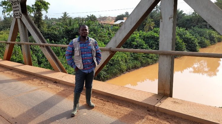
Dr Patrick Nii Lante Lamptey is a lecturer in Environmental Health and Sanitation Education at Akenten Appiah Menka University of Skills Training and Entrepreneurial Development. With a background in Remote Sensing and GIS in Water Resources Management, he is passionate about leveraging geospatial tools for environmental sustainability.
Images & Supporting Data
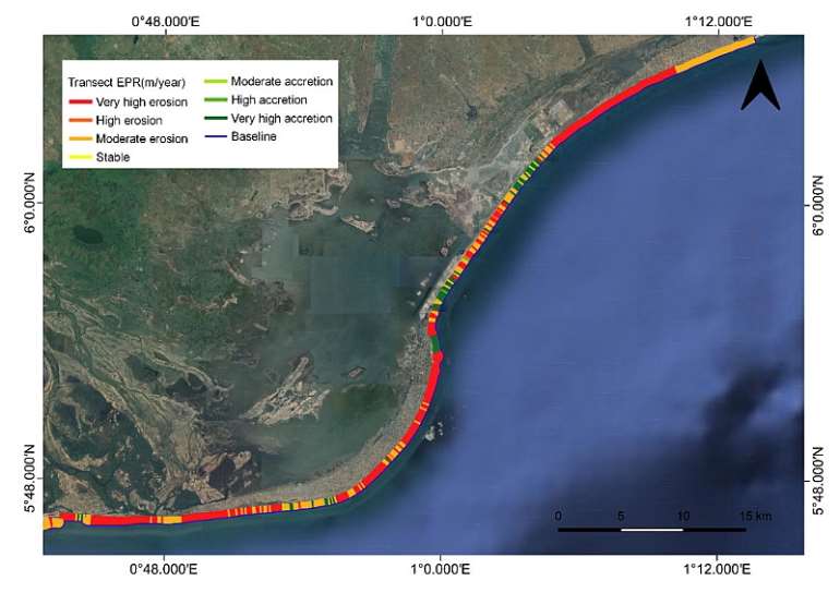
Figure 1 Map showing erosion and accretion hotspots
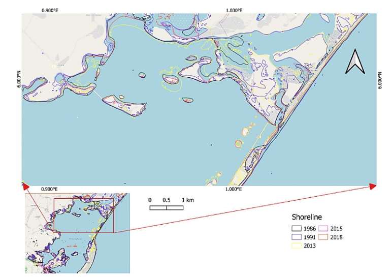
Figure 2 Map showing historical shoreline and Lagoon banks
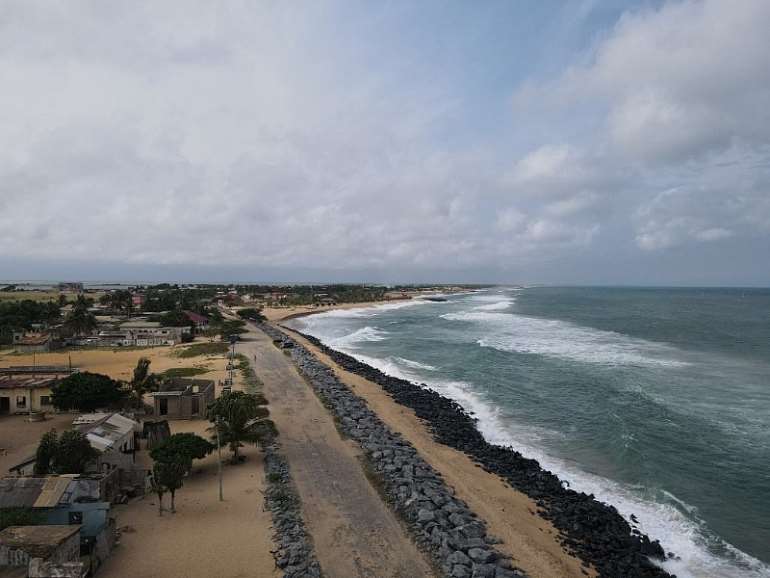
Figure 3 Sea defence along the coast of Keta
Research link: https://link.springer.com/article/10.1007/s11852-022-00893-0
 PURC increases electricity and water tariffs effective July 1
 GWL charges customer over GH¢74,000 for illegal reconnection
 Interior Ministry suspends Kantanka Security Services licence over Adwoa Safo sh...
 Torrential rains wreak havoc in Central Region as 18 killed, hundreds affected, ...
 Police invite Nana Kwadwo Safo Akofena over Kwabenya shooting incident
 Biakoye NPP Vice Chairman commends Agbodza, demands urgent fixing of deteriorati...
 Pregnant mother of three hospitalised after alleged assault by husband
 Senior student allegedly slaps Junior repeatedly over missing mobile phone at Nc...
 There was no gun in Adwoa Safo’s car, I saw more than 30 bullet holes on her car...
 NPP Bantama Chairman, Vice Chairman arrested after clash over constituency album...
