
In a series of papers, it has been my intention to attempt to demonstrate that our ancestors were rather more in maritime contact across the world than is generally accepted, especially in academic circles. These papers tend to concentrate on the African aspects of this and they include both sides of the continent of Africa at both Before Common Era (BCE) and Common Era (CE).
Those titled East Africa & the Sea in Antiquity plus Egypt & the Sea in Antiquity clearly indicate east Africa both north and south of the Horn of Africa and that on Egypt touches on the Egyptian coast facing the Red Sea and the Mediterranean Sea. The articles dealing with the Atlantic-facing or western parts of Africa are West Africa & the Sea in Antiquity; West Africa & the Atlantic in Antiquity plus Abubakri II: Who He? The titles of the first two of last three mentioned are self-explanatory but the last-named is less so but deals with later Africans on the Atlantic.
The school of thinking generally labelled Africa-centred/Afrocentric has prompted considerable opposition that is equally called anti-Afrocentric. Concerning Egypt, the charge against has been very forcefully led by the American writer named Mary Lefkowitz in the co-edited “Black Athena Revisited” (1996) plus her own “Not out of Africa” (1997) and numerous essays.
Against the application of Afrocentricism to seafaring Africans on the Atlantic probably the strongest challenge has come initially come from Bernard de Montellano; Gabriel Haslip-Viera and Warren Barbour (Ethnohistory 1997; Current Anthropology 1997, etc.). This was in such as “They were NOT Here Before Columbus: Afrocentricity in the 1990s” plus “Robbing Native Cultures: Van Sertima’s Afrocentricism & the Olmecs”
The “Did They” of the title refers to whether Africans ever had such as maps. This might be expected more of east Africa both south or below the Horn of Africa and east Africa north of the Horn. This may be because both Below-Horn plus Above-Horn east Africa were better known to the outside world, came under the influence from certain parts of that outside world and/or both these features among any number of other ones.
As to west Africans having sailed on the Atlantic Ocean in Pre-Columbian times, what we will describe as the Ethnohistory trio plus many others have flatly dismissed any such notion. Another possibility of explaining the similarities of west African traits and some in the Caribbean plus Mexico and Mesoamerica are what are called drift voyages. This especially means those on what have been described as marine conveyor-belts or sometimes as conveyor-belt currents.
This basically means vessels caught up by currents bearing them across the Atlantic Ocean whether the crews wanted this to happen or not. In such a circumstance, did crews ever need a chart or map of any kind? This is not helped by the general non-belief in and dismissal of possible ancient scripts in west Africa.
The East in Africa
Another group of Africans that could generally have been seen as not needing maps as we know them would be inhabitants of southern Africa that have given several names by mainly non-Africans. Among them are San, Khoisan, Capoids, Khwe, Bushmen, Basarwa, Quena plus many other others, not getting involved in the niceties and complications, Khwe is used here as an umbrella to cover them all.
The paintings on rocks held to characterise the Khwe have a wide distribution across southern Africa and serves to indicate the Khwe-like peoples once much larger tracts of Africa than they do now. There are hints of an even larger one-time extent. At dates centring on ca. 450 BCE for the Greek named Herodotus, we read Herodotus describes Nasamones captured by small Blacks that other ancient writers state were still to be seen somewhere on the Senegal (?). It may also be suspected that groups once called the Akkas/Accas attested in the northeast of Africa may be more of the Negroid-like members of such peoples of one of the later Out-of-Africa movements that stayed in Egypt.
As these groups were basically hunter/gatherers, it can be expected that the pattern of those still to be found in southern Africa was formerly to be detected over that same extent. Elements held in common with hunter/gatherers the world over probably means coming together to form bands of varying numbers with territories that may be defined but very flexible in their borders. Whether this is reflected in the rock-art already mentioned remains very uncertain.
However, some anthropologists regard some Khwe rock-art attest maps of some sort. In general, it is held these hunter/gatherers knew where they were going by memorising the topography and related features. Nor need these mental-maps have been solely for this world. This is because the witch-doctors/medicine-men or shamans travelled into the Otherworld in their shamanic visions and some writers regard it as probable that it is these shamanic journeys that are being recorded as an element in the just-seen rock-art.
Shamanic practices also passed to those generally classified as Bantoid/Bantu and more or less neighbours over much of southern Africa. This may not have been the only such interaction, as another may have been the transmission of cattle-keeping that for some of the expert opinions already noted came south with Proto/Bantu groups. If so, such dates as those for the Lukenya Hills (Kenya) may attest early stages of the Niger/Congo (=N/C) ancestors of the Proto-Bantu in southern Africa but the Lukenya dates are problematical, controversial and generally set aside.
Equally as controversial is the opinion of some of the expert views cited already. The Khwe are usually held to be the oldest extant human type with this evidently proven by genetics yet it seems that the Proto-Bantu may have become the neighbours of the Khwe at dates shown by such writers as messrs. Diamond (in Discover Magazine 1994 & online), Lacroix (Africa in Antiquity 1998) plus others.
Diamond (ib.) and Lacroix (ib.) base this on the N/C ancestors of the Proto-Bantu having come south as growers of palm-nuts plus yams not cereals and are felt to attest the Late Stone Age in southern Africa. In similar vein is Graham Campbell-Dunn (Maori: The African Evidence 2007) has suggested that in reduced Bantu prefixes lies the probable origin of the click-sounds that are probably the only feature most will know about these Khwe Click-tongues.
Skeletons found at Bambandyanalo (South Africa), Mapungubwe (South Africa), etc, that had mainly Khwe-like plus some Bantoid affinities. They are discussed in “A fragmentary skull cranium & dated Late Stone Age assemblage from Lukenya Hill, Kenya) by messrs. Gramley & Rightmire (Man 1973); in “Expansion of Bantu speakers vs. development of Bantu in situ” by Richard Rightmire (South African Archaeological Bulletin 1978); Felix Chami (The Unity of African Ancient History 2006); sources cited by Robin Walker (When We Ruled 2006) .
It has to be said that this represents a small but growing number of authoritative opinions. What they are telling us that the Proto-Bantu were probably in parts of southern Africa millennia before the received wisdom says they were there. In the same light are a number of a number of maps by Europeans that will be returned in pages below and with some of the stages that may have occurred well attested by the people of Kenya called the Mijikenda (= the Nine Tribes).
The Mijikenda occupy mainly coastal locations stretching from northern Tanzania through Kenya up to Somalia. Their grouping has evidently been recorded from at least the early 1900s and seemingly attest and yet each of the nine tribes is still identifiable, so would appear to attest just how slowly the full fusing process can take.
There is also some confusion about the Mijikenda as a whole to judge from articles online. It seems they can be regarded as part of the Swahili or related but separate from the Swahili or as the inland section of the Swahili. With the opinions followed a little above that Khwe and Proto-Bantu co-existed across southern Africa at dates rather earlier than generally accepted, it seems the sea-going Bantu called the Swahili also emerged rather earlier than expected. Messrs Steere (Handbook of the Swahili Language 1885), Tolmacheva (Essays in Swahili Geographical Thought 1995) plus others refer to the Swahili use of the early form of navigational device or simple compass –form called the wind-rose.
The Swahili were the great African sailors of Below-Horn east Africa with whatever earlier African navigational/time-keeping terms they once had become largely replaced by an Arabic one according to what is written by Marina Tolmacheva (ib.). It should also be said that other past authorities have sought Persian sources for this nautical terminology but James Allen (Swahili Origins 1993) points out this Persian vs. Arabic among the Swahili tended to rise and fall with that of the popularity of those sources in east Africa.
This especially means the Swahili of the island of Zanzibar. James Hornell (Antiquity 1946) shows the Noah-like “Role of Birds in Early Navigation” by the Swahili of Zanzibar. The name of the Swahili comes from the Arabic for coast and the Swahili word for coast is the Pwenet that Jona Lendering (The Circumnavigation of Africa online) relates to the Punt of the ancient Egyptian records. Another spelling of Pwenet/Punt occurs in the Pwani of the Swahili Mkubwa wa Pwani (= Great Old Man of the Shore). He is said by Tolmacheva (ib.) to have been an expert on seasons plus sailing. Besides this example, Tolmacheva (ib.) also gives us fundi wa Bahari (= Master of the Seas) as a more northerly version of the Mkubwa wa Pwani.
Among other names generally identified with the Swahili are Zanj and Shirazi. Zanj is one the many Persio/Arabic terms for east African blacks. Shirazi has actually been traced back to Shiraz (Persia/Iran). Felix Chami (Southern Africa & the Swahili World 2002) shows this to be a false etymology when showing Bantu/Swahili words combine to form Shirazi (= Dweller by the Shore). Another compounded word is that of the Tanganyika half of Tanzania coming from tanga (= sail/to navigate under sail) plus nyika (= land) giving a place to sail or navigate to.
The Swahili are known to have sailed to as far as China. In “The Boats of the Indus Civilisation”, Robert LeBaron Bowen (Mariner’s Mirror 1956) sought a tradition of sea-going rafts from the Pacific and across the Indian Ocean. In parts of east Africa facing the Indian Ocean are the traditions noted by messrs. Junod (The Life of an African Tribe 1926); Culshaw & Culshaw (Tanganyika Notes & Records 1933) and Philips (Journal of the American Research Centre in Egypt = JARCE 1996). Henri Junod (ib.), Culshaw/Culshaw (ib.), Jacke Phillips (ib.) were referring to the Thonga (of northwest Africa/south Mozambique), Turu (of Tanzania), Puntites (of east Af. facing the Red Sea?) respectively.
Scott Balson (Balson Holdings Family Trust online) shows that canoe-borne migrants from what is now called Tanzania reached Fiji according to Fijian tradition. Not as far is the distance between Mozambique/Tanzania and the large island of Madagascar. According to “Indo-Africa” by Cyril Hromnik (1984) plus “Evidence for Austronesian voyages on the Indian Ocean” by Roger Blench (1996), this large island had Pre-AN settlers. They were Indians and east Africans respectively. This accords with what is said in “Madagascar & the Malayo/Polynesian Myths” by Keith Taylor (in Explorers in Early Southeast Asian History 1976).
Blench has written several works on the subject of Austronesians (= ANs) as colonists west of Island Southeast Asia (= ISEA). These Austronesians apparently came first as traders across the Erythrean Sea (= the western Indian Ocean) and according to the origin-myths cited by Taylor (ib.) found inhabitants there already and intermarried with them. In “East Africa & the Sea in Antiquity” (online), sources were cited showing Austronesians on rafts (?) both east and west of ISEA on the Pacific and Indian Oceans respectively.
Something of the use of rafts in east Africa has been touched on and included that of a Puntite example by Phillips (ib.). The latter was seen as a mainly timber platform on inflated animal-skins and as capable of reaching Egypt. Something similar was still going on into the 1st c. Common Era (= CE) to judge from Pliny (1st c. Roman) citing pirates of the Arabian coast at one end of the Red Sea and the Periplus the Erythrean Sea (= PME) citing with cargo en route to Cana (Israel?) at the other end of the Red Sea.
This type of Puntite raft being depicted at the tomb-temple of Queen Hatshepsut at Deir el-Bahari (Egypt) means they plainly antedate the migration(s) of Austronesians. Reasons for not following the Petrie/Rohl thesis of Dynastic/Eastern rulers coming by sea from Sumeria in south Iraq are given in “Egypt & the Sea in Antiquity”. So too is the argument for why Punt is to be seen as probably seen as somewhere facing the Red Sea. The Deir el-Bahari wall-art includes maritime scenes having among them some of fishes firmly identified with those of the Red Sea. The case put forward by Dmitri Meeks (Mysterious Lands edd. David O’Connor & Stephen Quirke 2003) has it that Punt was in Arabia.
He says that the Hatshepsut reliefs showing such as a giraffe plus a rhino are not convincing as evidence of Punt was in Africa. He especially wrote that the rhino has one horn; therefore, it has to be from Asia. This overlooks the possibility of young African males that had not grown a second horn also that of Asian rhinos, The Sumatran males do have two horns. It seems the dromedary was domesticated, whereas the donkey underwent this in east Africa at about the same date. Taking the scene of the Queen of Sheba in Arabia leaving for Israel as broadly coeval with the reliefs of Queen Hatshepsut in Egypt, the Old Testament has “Sheba” going by camel. So if Punt was in Arabia, camels should have been depicted at Deir el-Bahari. They are not. The beast of transport depicted at Deir el-Bahari is the donkey not the camel.
It may be there is ambiguity about the location of Punt but it is also the case that the entire fauna depicted at Deir el-Bahari has a decidedly African slant. Richard Pankhurst (The Ethiopians: A history 2001) also noted that among the products Egypt sought in Punt were the African ebony plus gold. Also inscriptions speak of rains in Punt ultimately feeding the Nile. With the best will in the world, it is difficult to regard this as denoting anything other than geographically showing Punt was somewhere in Africa.
This fits with Shungwaya in Somalia as the home of the gods of the Bantu well to the south of Somalia and Ta-Neter also partly in Somalia as the home of the gods of Egypt well to the north of Somalia. It has already been shown that Bantu Pwenet may relate to Egyptian Punt. It may be that Punt is to be seen as including not just north Somalia but also Djibouti plus Eritrea/east Ethiopia.
A sort of parallel for this distribution comes with the astronomy that Felix Chami ((The Unity of African Ancient History 2006) says was being noted by Iambulus (ca. 300 BCE?) plus Euhemerus (ca. 300/250 BCE?) in the “islands”. These islands would appear to include those off Tanzania plus Kenya and possibly reaching Madagascar and this may connect with the east Africans seen on Madagascar on different grounds. More African astronomy is that shown by Frank McCosh (African Skies online) of Pre-Shona date is well shown at the later Great Zimbabwe.
Yet more practice of African astronomy is to be shown by the settings of the stones at Namoratunga (Kenya). This has been regarded as related to the calendrical system of the Borana in north Kenya and the Oromo (= Galla) of Ethiopia. What was seen as the Pwenet/Punt coast was also shown to include Ethiopia/Eritrea. This seemingly matches what has been written about the African Ausan/Awsan. With Awsan being described as a kingdom of Yemen (= southwest Arabia) and the Casson (1989) translation of PME omitting the African Ausan, some of the complications become very obvious.
What may also be analogous is such as Mocambique (= Island of boats & most likely origin of Mozambique); Shirazi (= the Swahili Moz. to Somalia); Kilwa (= place of fishing, Tanzania); Mombasa (= Place of boats, Kenya); Shirazi (= People of the Shore = the Swahili of Moz. to Somalia); Djibouti (= Place by the sea). A combination of the PME and Pliny was given above and they do so again. What emerges from most translations of PME is the African Awsan (= Azania?) evidently mapping from Mozambique to Somalia but with the Sea of Azania stretching from Somalia to south Sudan according to Pliny.
This means the Plinian description is mainly of the Red Sea. Here too are problems. One of them being the umpteen names there has been for the Red Sea in antiquity. For Herodotus (5th c. BCE Greek) it was the Arabian Gulf and a later name is the malono d’kush in the Causa Causorum (7th CE?) by Jacob of Edessa ((?). What ancient Ethiopia called it is not known but from the ancient traditions gathered in the Kebra Negast (= Book of Kings), Ethiopia would have dominated the southern Red Sea for several centuries.
Undoubtedly, Axum is the most famous site of ancient Ethiopia/Eritrea but excavations have proven what have been called Pre-Axumite levels. Pre-Axumite Ethiopia included what is now Eritrea (lost to Eth. due to recent war) and was tentatively linked to Makeda as Queen of Sheba in the introduction to the Budge translation of Kebra Negast. The Kebra is the national epic of Ethiopia.
Makeda is not just seen as connected to Pre-Axumite Axum but was also the Queen of a Sheba set in Ethiopia according the Kebra. The Kebra further has it that Queen Makeda presided over a large mercantile fleet that traded to as far east as India. In later times, Axumite conquests on south Arabia were based on control of the sea. We have seen mention of pirates at one end of the Red Sea and when the Axumites brought the Solates under control, the Solates were tasked with keeping the sea-lanes clear of pirates. An admiral-type figure was appointed as being in control of this anti-piracy was called the Barnagash (= Lord of the Seas).
The Barnagash can apparently be seen as continuing the appointment of officers seen to have Shirazi/Swahili analogies, so this can be added to what has been suggested about Places/Peoples of boats/coasts seen to stretch from Mozambique up to at least to Djibouti. That an Ethiopian concern for the sea carried on is shown by sources cited in (Indigenous Mapmaking in Intertropical Africa) by Thomas Bassett (in Vol. II Bk. III of History of Cartography edd. messrs. Woodward & Lewis 1998). To as late as the 18th c., Imperial Ethiopia was making maps. Bassett (ib.) figures those drawing on ancient Axum/Aksum as the centre of Ethiopian maps down to the 18th c.
Mention has been made that the Sea of Azania was seen as far north as southern Sudan and that this means most of the Red Sea. Another of the ancient names for the Red Sea was also shown above. This was the malono d’Kush brought to our attention by Hideyomi Takahashi (Hugoye = Journal of Syraic Studies 2003) and means the Sea of Kush. What is meant by Kush is much of what today is Sudan.
A particularly ancient method of navigation is that of a vessel proven on a pebble found during excavations by messrs. Usal and Salvatore (cited in East Africa & the Sea in Antiquity online) at Salwa (Sudan). It dates to ca. 7000 BCE and what is being depicted is a pole-mounted rudder. The Usal/Salvatore (ib.) article mentions what they describe as the oldest depiction of a Nile boat.
Kushite boats moving up the Nile to Egypt were a constant threat to Egypt. Frank Yurco (in Lefkowitz/Rogers ib.) wrote that the forts built by Senwosret III at such as Toshka, Buhen, Semna, etc, begin to make sense. What Yurco (ib.) meant was the excavations at Kerma (Sudan) by Charles Bonnet found paintings showing a powerful Kushite riverine fleet. The point is reinforced when we follow those authors describing the immense size of the Buhen fort. Moreover, The Kushite fleet was still a threat to Egypt when King Apophis of the Hyksos-ruled part of Egypt invited the King of Kush to bring his fleet northwards up the Nile to invade in a letter intercepted by king Khamose of the native-ruled parts of Egypt.
This answers very fully the fact that “Black” Africa did not need the earliest Europeans in Africa to teach them the value of a navy and more such expertise comes with the figure of Nehessy (& umpteen other spellings). This seems to be a major term for Black Africans and an individual so named is identified in the inscriptions accompanying the reliefs at Deir el-Bahari. Despite such disasters that befell such as the vessel described in the “Tale of the Shipwrecked Sailor”, the fleet of ships depicted in these reliefs got to Punt and back home to Egypt. Nehessy was the admiral that led this expedition.
Another expedition in this direction may also help in showing just how far south the Kushites came. We have seen one of the ancient names for the Red Sea translates as Sea of Kush and to this is added Marina Tolmacheva (Navigation in Africa online) citing Islamic sources saying Kushites in the Horn of Africa drove off invaders. Just where the story came from is at best uncertain but satisfyingly showing Puntites and Kushites in touch with each other would be such as the El Kab inscription telling of Puntites and Kushites as allies victorious against Egypt. This left Egypt wide open for invasion. The lack of a follow-up apparently gave Egypt time to recover and counter-attack.
Further was that vessels from the northern Horn/southern Red Sea were to be seen in the northern Red Sea according to what has been cited above. Don Gibson (Ancient Sailing & Navigation online) is one of those drawing attention to the tricky navigation for sailors at the northern end of the Red Sea. Here they would be ideal for the emergence of such as wind-roses. In his opinion, these conditions led to the Red Sea evolution of as the naggar/balanced lug-sail into the mizzen-mast that led on then to the Indian Ocean in one direction and the Mediterranean Sea in another.
One of the most famous names attached to that of Kush must surely be that of Memnon. Many writers follow the opinion that the Kush being referred to takes us to the east and they do so on grounds that are shown in “East Africa & The Sea in Antiquity” (online), as so for Kush being shown to be south not east of Egypt by the oldest literary texts, those of Assyria plus Israel. A now-lost source was that of Dyctynnis Cretensis (= Dicytis of Crete) according to Lucius Septimius attempting to reconcile the anomalies of this by writing of Memnon bringing both Africans plus Indians to Troy. The African linkage makes more sense in the light of the lines in the Quintus Smyrnaeus version of the Iliad showing the maritime ties of Memnon when shipping African troops to Troy.
Undoubtedly, the most famous ruler of Kush was Taharquo. The umpteen spellings of his name include Tarhaqo, Tirhaka, Tirhakah, Tearco, Tearcon, Tarachos, Tarraco, Tarchu, Tarchon, etc. Between them, William Winning (Manual of Comparative Philology 1838), Winifred Brunson (Great Ones 1929); Ivan Van Sertima (in African Presence in Early Europe 1985 & 2000); Peggy Brooks-Bertram (in Egypt: Child of Africa ed. Van Sertima 2002); Henry Aubin (The Rescue of Jerusalem 2002) cover most of the points taking this forward.
Much of the Brunson book could be criticised for choc-boxey art but the contribution on Taharquo was by Henri Frankfort. He was one of the foremost authorities on Near Eastern antiquities for much of the 20th c. and describes battles between the Kusho/Egyptians ruled by Taharquo and the Assyrians. Frankfort (ib.) says these battles were ferocious and decimated the Assyrian armies in Egypt. Aubin (ib.) adds that he regards as the real reason for the “rescue of Jerusalem” was another defeat of the Assyrians by the Kusho/Egyptians, so much for those writers following the Egyptian and Assyrian descriptions of wretched Kush, cowardly Kush, etc.
Mapped itineraries to be touched on later seemingly attesting domination of the east Mediterranean by rulers may include the Kushite Pharoahs of Egypt. Aubin (ib.) thought Kushite kings were proven in southern Syro/Palestine by the weight-systems of Kushite-ruled Egypt found there. To this Gregory Gilbert (Ancient Egyptian Sea Power & the Rise of Maritime Forces 2008) showed that in order to effectively to rule Palestine, control of the sea-coast was necessary. Not for nothing does Brooks-Bertram (ib.) cite Bruce Trigger and Daniel Luckenbill saying Kushite kings were the allies of rulers overseas from in Cyprus plus Crete.
This may connect with comments by Winning (ib.). He thought the name of the Kushite Taharquo was echoed by that of Tarchu/Tarchon who was the leader/founder of the Etruscan confederacy. This accords with a reference by Polybius about blacks on the River Eridanus that is identified by Peter Beresford Ellis (The Druids 1994) with the River Po (in north Italy again). Further west still is Iberia (= Spain & Portugal). Winning (ib.) also thought the name of Taharquo/Tarraco lay behind that of Tarragona (Spain). Now would this be the only example of Taharquo’s name in Spain. This is because such as Strabo (1st c. BCE Greek), Procopius (6th c. Greek), al-Makkary (16th/17th c. Algerian), etc, tracked Taharquo to as far west as the Pillars of Hercules (= Straits of Gibraltar). According to Aubin (ib.), this puts him in the elite company of such as Sesostris of Egypt, Hercules of Greece, Nebuchadnezzar of Babylonia, etc.
Emerging from this is that there was probably greater contact between the different parts of Africa than is generally accepted. It has long been acknowledged that certain designs painted or carved on rocks may well represent maps. Certainly, information reaching northeast Africa from much further south would come with the Red Sea trade that Juris Zahrins (in the Indian Ocean in Antiquity ed. Julian Reade 1996) plus others say had reached Egypt in Pre-Dynastic days.
However, easily the most famous instances of Red Sea traders involved with Egypt are connected to the Punt-to-Egypt commerce. Those on these expeditions can be expected to have known something of the geography plus topography of Punt. Yet despite this according to the Deir el-Bahari account, Puntites ask the Egyptians why they had come and where had they come from? Had they flown to get to Punt? We should remember that despite what would have been accumulated about Puntite conditions, “The Tale of the Shipwrecked Sailor” tells of wrecked ships. Nor can we ignore that Egypt still needed to know about what was happening to the south when we come to the reign of Necos (= the Necho of Herodotus).
It does appear that the Punt-runs of earlier times were being revived but in a differing form. The major difference was that this did not involve Egyptians directly, as Egypt employed Phoenicians to go on this expedition. It also seems not improbable that the Phoenicians plus their settlers at Carthage attempted some kind of coordinated accumulation of knowledge about matters overseas. Some evidence for this lies with Necos/Necho sending the Phoenicians on their way at dates akin to those for Carthage sending Himilco to explore the Atlantic-west coast of Europe and Hanno to do so likewise on the Atlantic-facing coast of Africa.
Egypt
The Punt-run has been discussed by numerous writers having among them David Jones (The Origin of Civilisation: The Case of Egypt & Mesopotamia from Several Disciplines 2007). He draws attention to an aspect not often touched on about these voyages. It is often said that Egyptian use of the Red Sea meant ships taken to the Red Sea coast, dismantled then dragged overland to the Nile then re-launched. Referring back to rock-art, there are scenes of vessels being towed across land. Alongside this are the remains of ship’s parts revealed by excavation at Sww/Saww (= Wadi/Mersa Gawassis, Egypt).
However, Jones (ib.) seems to regard this as unlikely and refers to the real possibility of canals instead. Yet this may not be so as opposed as he thinks. It can be assumed the overland towing belongs to a pre-canal phase and that the canals belong to a later stage. Writing about what might appear to be something entirely unrelated, Morris Silver (Making a Case for Technological Interpretation of the Parting of the Sea online) concluded the answer lay in a canal that had its locks closed to allow the Hebrews to cross then they were reopened to allow the water to flow again. This then trapped Pharoah’s charioteers with the subsequent drowning of some.
This then would be but one literary reference to a possible Egyptian canal-system joining the Red Sea and the River Nile. Others include those that attributed to the reign of the 6th Dynasty (ca. 2345-ca. 2180 BCE) Pharoah named Pepi I (ca. 2330- 2280 BCE) and that said to have been built by the 12th Dynasty (ca.1990-ca. 1780 BCE) named Senusret I (ca. 1970- ca.1920 BCE). Some state these Pharoaonic canals are purely conjectural and others that they only linked internal waterways of Egypt. However, the 12th-Dynasty emphasis of the finds from the Sww/Saww excavations mean that such a canal makes complete sense in the light of Sww/Gawasis plus the route to Punt.
This gives us a scenario where geographical knowledge was such that it could be recognised that the route to Punt could be improved by a route going from the Nile via other internal waterways and giving access to the sea. Jones (ib.) feels this canal is further shown by what seems to be such a canal on what has been called the Hamy-King Map itself apparently to be seen as one of a series of maps incorporating some especially ancient knowledge. These maps will be further touched on in pages below.
The building of an Egyptian ship of the class that has been called KPN/KBN for a Punt expedition under the supervision of Enenkhet occurred in the reign of Pepi II (ca. 2280-ca. 2185 BCE) when Enenkhet was killed by local tribesmen. The term of KBN/KPN is usually thought to arise from the Egyptian term for Byblos on what is a Mediterranean coast by being part of what is now Syria. This means that ships on the Red Sea voyages from Egypt to Punt were the same as those on the runs on the Mediterranean Sea from Egypt to Byblos.
This shows an Egyptian interest in west Asia that had probably begun in Pre-Dynastic times to judge from items marked by the name of Narmer on items found in southern Syro/Palestine (= Palestine, Israel & Syria). A relatively keen commercial interest may have sometimes become an even keener politico/military one. According to Herodotus (5th c. BCE Greek) one such occasion was in the reign of a Pharoah he names as “Sesostris”. This Pharoah is identified with Senusret I by Martin Bernal (Volume II of Black Athena 1991) but this has led to a hot debate meaning that Bernal (ib.) has come under heavy critical attack.
A much-cited piece of criticism is that by Emily Vermeule (in Black Athena Revisited ed. messrs. Lefkowitz & Rogers 1996). Vermeule (ib.) pointed up the incident when Senusret III of the 12th Dynasty returned in triumphal procession from an attack on Kush/Nubia in a ship with the body of a dead Kushite prince tied to the stem. She asked the rhetorical and vitriolic question is this normal tribal politics? This was as part of a book in which a whole gaggle of leading academics line up to inform us Bernal is simply wrong and take several hundred pages in doing so. The overall intention is to dismiss Bernal’s contention of African links for Egypt. Nowhere in this and more specifically, Vermeuele’s comments, is there any mention of the seven dead Palestinian chiefs attached to the ship of yet another 12th-Dynasty Pharoah.
If the single dead Kushite supposedly rules out Kushite links for Egypt, what do seven dead Palestinians say of Egypt and Syro/Palestine? Not only would this wilfully ignore geography but this would not be the first time that an Egyptian dynasty of Kushite origin would turn their backs on their original homeland. Toby Wilkinson (Genesis of the Pharoahs 2003) wrote that in Kush were the ancestors of Dynasty O but that they not merely lost contact with their origins but often turned bitterly against Kush. Flinders Petrie (The Making of Egypt 1939) felt several subsequent dynasties had Kushite sources but attacks on Kush were a consistent element of Egyptian history.
Another component in the criticism of Bernal’s views is his daring to connect what is written by Herodotus with what is to be read in the Mit Rahina inscription. Herodotus (5th BCE Greek) was describing the campaigns of an Egyptian Pharoah through the Levant (= Syro/Palestine), Anatolia (= most of Turkey), the Balkan (= s/east Eur.). The inscription from Mit Rahina (part of the Thebes complex, Egypt) lists a number of places that appear to be mostly coastal parts of the Levant (inc. Cyprus), Anatolia plus the Balkans. It is Bernal (ib.) who makes the case for seeing what Herodotus has reported about “Sesostris” as the Greek equivalent of what is inscribed on the blocks from Mit Rahina.
From the various sources looked at for this article, Sesostris has been variously identified with Senusret I, Amenemhet II, Senusret III, as a combination of all three or of most of the rest of the 12th-Dynasty Pharoahs. Others look to Ramesses III of the 18th Dynasty. The 12th-Dynasty seems to be usually regarded as the most probable.
There is enough toponymy in Mit Rahina for there to be near-general but not universal agreement about place-names on land that are mainly coastal with an emphasis on the Aegean (esp. the islands of that sea). Both Bernal (ib.) plus Ezra Marcus (Egypt & Levant 2007) discuss this inscription but come to very different conclusions as to what it represents. Those of Bernal (ib.) have been noted but Marcus (ib.) denied Bernal because he had misused the Mit Rahina text.
The slant taken by Marcus (ib.) is nicely summed up the title of his article. That title is “Amenemhet II & the Sea: Maritime Aspects of the Mit Rahina (Memphis) Inscription”. He also refers to a hoard of treasure contained in four copper boxes at the temple of Montu at Tod (Eg.). It is suggested this has affinities as far east as Persia/Iran, Sumeria/south Iraq (esp. Puabi’s tomb?) but more generally with Anatolia, the Balkans (inc. mainland Greece) plus island Greece in the Aegean. For Marcus (ib.), the Mit Rahina text is more or less the literary counterpart for the Tod Treasure. As seen above, Bernal (ib.) wanted to go further.
He did not solely cite Herodotus on this ground but also drew on Manetho, Diodorus Siculus, etc. There is a sense in which the rampaging Pharoah that emerges from the pages of these writers links very directly with the Tod Treasure. The rampaging Pharoah named Sesostris seems most popularly identified with Senusret I (esp. the Bernal school), his son named Amenemhet II (by most archaeologists) or possibly both. This especially arises from the fact that both names appear in the dedications (by A. II) and the names of both father and son appear on Mit Rahina.
The geography known to ancient Egypt about parts away to their east is thought be made somewhat clearer by what are seen as maps on the bases of statues in the tomb-temple of Amenhotep/Amenophis III (ca.1385-ca. 1850 BCE) at Kom el-Hetan (Eg.). By now we are with the 18th Dynasty (ca. 1550- ca. 1290 BCE) that includes such as Hatshepsut, Tuthmosis/Thutmosis III, etc, as other notables.
During the period of the 18th Dynasty, there were extensive conquests by Amenhotep III, Tuthmosis III, etc, the most famous of the Punt explorations, etc. We might almost take it as echoing the exploits of the 12th-Dynasty Pharoahs (& observe the numerous spellings of Eg. names, the insertion of vowels for western convenience & logic of the Eng. oa [not ao] followed in the spelling of Pharoah here). Even the Aegean itinerary of the Mit Rahina seems to find its later analogy in the claimed map on the statue-base En at Kom el-Hetan according to “Amenhotep III &b the Aegean: A Reassessment of Egypto/Aegean Relations in the 14th Century B.C.” by Eric Cline (Orientalia 1987).
The Marcus study of the Mit Rahina list and that of Cline of the Kom el-Hetan maps have other obvious points in common. Among them is the comparison of archaeological material putting flesh on the bones. More of the same seems shown by the Egyptian ship-types bearing the names of KFTW plus KPN/KBN. It is generally agreed these terms arise from the hieroglyphs for ships plying between Egypt and Byblos plus Egypt and Crete respectively.
It will be immediately obvious why there was a need for Egypt to have had maps of the region and also for sky-maps that would help in getting from home to intended destination and the return voyage. We can further note Apollonius Rhodius cited by Phillip Coppens (The Canopus Revelation 2004) about an Egyptian king city-building in Europe plus Asia and leaving maps inscribed on stone. Gwen Parker (Atlantis Online) cites Coppens saying this is powerful evidence that Egypt was seen as the homeland of the concept of geography by ancient writers.
This mapping of the sky has long been suggested to lie behind the Hymn to the Sun supposedly written by the heretical Pharoah named Akhenaton. There are also many years behind comparisons of it and Psalm 104 as part of the emergence of Hebrew monotheism and both refer to ships. Egypt is said by Greek sources to be where Eudoxus learnt about the Precession of the Planets according to Ian Ridpath (Star Tales online). This is best known from the poems by Aratus (ca. 300-ca. 250 BCE Greek). Aratus looms large in “The Origins of the Constellations” by Michael Ovenden (Philosophical Journal 1966). Not only does mapping the heavens help sailors but Aratus was writing a manual for seamen according to Ovenden (ib.).
To the West
A part of Africa not often seen as in touch with Egypt is western South Africa/Namibia in the deep southwest. In “The Curse of the Cocaine Mummies”, Paul Buckland & Eva Panagiotakopulu (Antiquity 2001) discuss the matter of the tobacco found in the mummy of Ramesses III. They consider the connection of Namibia and Egypt in the remote past as unlikely as that with the Americas. Yet messrs Merxmuller & Buttler (cited by Buckland/Panagiotakopulu ib.) refer to a strain of Nicotiana africana as possibly the origin of that said to have been found in an Egyptian mummy, namely that of Ramesses III. As to ancient contact with the Americas/New World, there is now abundant testimony for this shown by Old-World drugs in in Peru in the New World balanced by other narcotics from the New World in the Old World country of Egypt.
Other hints of southermost Africa being known in remote antiquity are shown above. The liklihood of Khwe and Proto/Early-Bantu co-existing across southern Africa millennia before the received wisdom allows has already been touched on. That the seafaring Bantu called the Swahili had some knowledge of the early compass-form was also mentioned above. The more so given that Shirazi comes from the Swahili compound meaning People of the Coast plus the Swahili term of Pwenet (= Coast/Shore) is the same as one of the variant spellings of the Egyptian Punt/Pwenet. We can also observe the similarity of some Bantu peoples seeking a homeland of Shungwaya in south Somalia plus the liklihood of Egyptians doing so in north Somalia (plus Djibouti/Eritrea?).
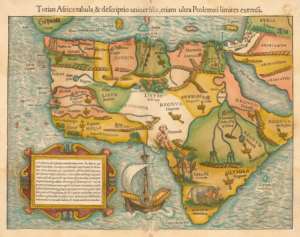
Various writers have alluded to the kings of the Black-ruled Mwenmetepe Empire. They state European maps attest the Bantu in the Cape Town areas of western South Africa at very considerably earlier periods before they were supposed to be. In “Ancient India, West Africa & the Sea”, “Africans & the Sea: Some Parallels”, etc, sources were cited as showing Bharati (= ancient Indian), Austronesians (= ancient Indo/Malays), Phoenicians (& their Carthaginian & Gaditanian colonists) probably had interest in western parts of South Africa long before the first Portuguese got there.
The just-noted articles also notice several maps that include the Wilford/Speke “Hindu”, Vesconte/Sanuto, Ptolemaic, etc, Maps. They attest what appear to be small African islands set in near-correct relationship to their nearest mainland being known to the outside world. This includes Robben Island in nearly the correct relationship with the Cape of Good Hope. The source of the information behind this is unknown but there is some similarity with other islands discussed a little above. The conclusion about them is comparable to that about these other islands, namely that Black Africans are responsible for the maps concerned.
In their short stint as rulers of that chunk of southern Africa once called Deutsch-sudwestafrika (= German Southwest Africa) but is now known as Namibia, the Germans proved they were no great lovers of Blacks by the slaughter of those subjected to that rule. Having machine-gunned or shelled thousands of Herrero plus Nama at the “Battle” of Waterburg, they then stationed troops at every available water-source, and denied water to the surviving Africans, forced most into the already-dry Kalahari then poisoned any wells the Africans might have accessed.
The Germans certainly valued would-be German colonists brought to Sudwestafrika or Southwest Africa/Namibia noted above the now German-ruled Africans, so it comes as a surprise who were used for the ship-to-shore ferrying of those colonists to Swakopmund (Nam.) in pre-jetty days. They were Africans using the same kind of dugout-canoe prompting praise by the well-known British maritime authority named James Hornell (Mariners Mirror 1928). This is a particularly archaic form but was being used by Europeans at the height of the European imperialism starting from what has been termed as the “Scramble for Africa”. However, here we see these canoes were being used to break through seas so ferocious that Europeans named the adjacent shores as the Skeleton Coast because of the remnants of wrecked ships plus the bones of their dead crews.
The Ijo Genesis (online) informs us that elements from western South Africa reached part of the Gulf of Guinea to become a strand of the formative stage(s) of the Ijo people. However, it is unlikely that the concept that the concept of the unified political state along the western littoral of Africa suggested by Leo Frobenius (Voice of Africa 1913) can be sustained. However, he did put forward a number of traits that might attest some kind of cultural not a political unity along these same western shores of the African continent from Angola northwards.
Angolans were reported by Elysee Reclus (The Earth & its Inhabitants 1891) described as present on the island Sao Thome in the Gulf of Guinea. Reclus (ib.) was inclined to put this to a wrecked vessel from Angola and whose crew made became complete pests to the earliest Portuguese colonists on the island. In the light of the foregoing, it may be allowed that the shipwrecked Angolans were part of something very purposeful and that this connected with the traders plying these coasts still around to be noted by Barbot plus others.
The more so given that Jan Knappert (The Aquarius Guide to African Mythology 1990) could describe the sea-god of the Kimbundu ethnia of around Luanda (Angola) as the Poseidon or Neptune of Angola. Of the all-fishing economies of the type known all round the African coast and called Ichthyophagi (= Fish-eaters) by the Greeks not only included the Kimbundu but other Angolans evidently belonging here are the Bakongo sub-clans called Solongo plus the Ashiluanda apparently spending most of their time on the open sea. This is more than a little emphasised by the fact that that the latter live on the island of Luanda.
Otherwise, the name of the Bakongo is best known from the River Congo plus the state-names of the Democratic Republic of Congo (= ex-Belgian Congo = DRC) plus the Congo (= ex-French Congo). The fishing connection continued up to the mouth of the River Congo to judge from something shown by Michael Bradley (Dawn Voyage: The Black African Discovery 1991). One of the plates in this book is of a painting by a Portuguese artist. It depicts a flotilla of canoes with sails apparently engaged in fishing but it should be borne in mind fishing is not the only reason why west Africans went to sea.
The spoken language of the Bakongo is Kikongo and for messrs. Lacroix (Africa in Antiquity 1998) and Lenderer (Hanno online), a little of this language became known to the outside world via the activities of Hanno and his men. Hanno had been sent on a voyage of exploration, discovery plus commercial assessment by the elders of Carthage according to Lacroix (ib.) and Lenderer (ib.). His men tried to capture hairy beasts that have been called gorillae since. This is said to originate in the Kikongo phrase of ngo didii (= animal beating its chest violently). More words to do with commercial activities known beyond the Bakongo emerge from words in the Kikongo-group language of Vili are shown by Kevin Patterson (The North Gabon Coast 1975) in that called Mahongwe (= Mpongwe) of Gabon.
Patterson (ib.) says this includes molaffa/malaffa/malassa (= honey), Mani (= Ruler), matambe (= bark-cloth), etc. Bark-cloth from here acquired so high a reputation that it became the height of fashion in parts of Europe. Otherwise the Mahongwe are known for the Bwiti apparently named after the Mbuiti/Mbuti (a branch of the Twa or Pygmies). Bwiti relates to a number of other cults of west Africa. It enables the shaman/witch-doctor to navigate into the Otherworld by taking certain narcotic drugs.
Navigation in this world would be shown by the Mahongwe as the other half of the ancient sea-based commerce involving canoes referred to by Peiter de Marees (17th c. Dutch). However, this has been described by Paul Hair et al (Barbot on Guinea 1992) as a mistake on the part of de Marees. Paul Chaillu (Exploration & Discovery in Equatorial Africa 1856) is rather rude about the canoes of the Mahongwe/Mpongwe. Equally as authoritative as Paul Hair, Adam Jones & Robin Law (ib.) are messrs. Markwart (as Hebert 1984); Smith (Journal of African History 1970); Patterson (ib.); Fage (The Cambridge History of Africa 1977); Herbert (1974; 1984) and they state something quite different.
It is possible the Mahongwe of Gabon gathered copper from South Africa, Namibia, Angola, DRC, etc. John Fage (ib.) is one those adverting to copper brought from the mouth of the Congo to the Delta at the mouth of the Niger is no longer in distance nor any more difficult than that brought from Saharan mines at Azelik (= Takedda?) to again the Niger Delta. Patterson (ib.), Herbert (ib), etc, attest the Mahongwe voyages to the Gulf of Guinea and Thurstan Shaw (Further Light on Igbo-Ugwu: Including new radio-carbon dates online) felt Gabonese copper may have been found at Igbo-Ukwu (Nigeria). To Patterson (ib.) saying Mahongwe canoes could cover this 600/650 miles and could carry up to 80 men can be added Richard Burton (Two Months in Gorilla Land & the Cataracts of the Congo 1876) saying Mahongwe canoes could bear 10/12 tons.
In Cameroon, it would appear that a section of the fishing-based economies that the Greeks called Ichthyophagi (= Fish-eaters) were called Ichthyophagi Aithiopiae (= African fishermen). The Ichthyophagi are traced round virtually all round the African coast and Martin Horton (Antiquity 1992) felt they initiated trade on some of those coasts. The term of Aithiopiae/Aethiopiae derives from a composite of the Greek words aithios plus opes giving us Aithiopes (= Burnt-faces = Africans). It occurs in the title a Greek text called the Aithiopika by Heliodorus (3rd c. CE). Among its features are a list of rivers starting with the Nile proceeding westwards to what Lacroix (ib.) identified with what he says was called locally the Chambi-sad (the Sea) and further with the Congo. It is not the only example of a river being simply called the sea or water because its size. The Thalassa Aethiopicus (= African Sea/Ocean) was also once a name for the southern Atlantic Ocean.
An ancient people of part of Cameroon but also stretching through Nigeria plus Niger up to Chad are the variously named So/Sao/Soo. Messrs Torneaux (as Dierck Lange) and Lange (Immigration of the Chadic-speaking Sao towards 600 BCE online) regard this as echoed in Soobe that they say evolved into Yobe. This in turn gives us Komadugu Yobe flowing partly as twin for Komadugu Gana towards Lake Chad. Komadugu Gana has a further relevance in not only having a spelling akin to that of Gana/Ghana but also for being where the Dufuna canoe was found. The canoe seems to be the oldest yet found in Africa and its date settles on ca. 6000 BCE. Peter Breunig (Africa’s Oldest Boat online) says it is more sophisticated than those of found in Europe of equal date and represents a long probable history.
The Dufuna Canoe was found in what is now Nigeria and so too is the Edo-built city called Benin. The Wikipedia entry on Benin (Nigeria) cites the old doggerel of “the Bight of Benin, few come out but many go in”, so demonstrates the perceived dangers of the Bight of Benin section of the Gulf of Guinea. This fits with Livio Stecchini (Re. Hanno online) saying the great civilisation of Benin attracted the attention of the Carthaginians led by Hanno, this would mean Benin was in a mature phase by ca. 600 BCE. The “History of the Gold Coast & Ashanti” by Carl Christian Reindorf (1896) cites non-Benin traditions giving Benin a considerable maritime reputation, so would mean this was a very lengthy one.
In “The Religion of the Yorubas” and “Chalk Iconography in Olokun Worship”, messrs. Lucas (1949) and Rosen (in African Arts 1989) draw attention to the worship of Olokun and Olori Merin best known as Yoruba cults. Olori Merin (= Lord of the Four Heads) is shown by Olumide Lucas (ib.) as having images that are cross-shaped with the heads on each of the arms of the cross sometimes stylised into roundels. The Horologion (= Tower of Winds) at Athens carries the heads of minor gods that are also the Greek names for winds from various directions and held to attest the best of Greek science of the time. In this light we come to the heads/roundels of Olori Merin also bearing the names of godlings and the Yoruba names for winds from the basic directions of the compass.
If these cross-shapes attest the direction on land, those of Olokun (= Lord of the Sea/Deep) will be their counterparts at sea according what is shown by Norma Rosen (ib.). The more so when those of Olokun are revealed by Rosen to often combine watery scenes whereby chevrons and/or s-shaped spirals represent waves with crosses in the same representation. Olokun as also god of wealth would appear to indicate recognition of wealth coming from the sea.
As the god of the deep, Olokun would appear to represent something to be akin something seen in Mali/Senegal plus Morocco. Eden Saga (online) relates Yoruba divination based on 16 nuts to the 16-point wind-rose/compass that is described there as a marine map. It can be noted Frobenius (ib.) felt Olokun was the Yoruba equivalent of the Greek Poseidon and that Yoruba tales of “Golden” cities offshore could be identified with Atlantis.
A particular feature of southern Nigeria is the vast size of structures called eyas best known from that called the Eredo. Just when they began is uncertain but as we now have them, the completed stages are generally put to the 10/11th cs. CE) and the reign of Queen Sungbo Bilikusa. They are placed second only to the Great Wall of China in terms of size and in terms of man-hours are said exceed even the Pyramids of Egypt. Both ancient China plus Egypt are held to be very organised states, so what does this mean for Nigeria? We can also recognise the skilled field-surveying this represents. Nor should we overlook the astonishing mental mathematics noted by Claudia Zaslavsky (Africa Counts 1999) among Nigerians and which apparently have a bearing on modern-day computistics.
Further are “African Sea Kings in America” by Joan Covey (in African Presence ed. Ivan Van Sertima 1992 & 1997); “African Navigation & Cartography by Charles Finch (The Star of Deep Beginnings 1998 & 2007”; “Indigenous Mapmaking in Intertropical Africa” by Thomas Bassett (Book III: Chap. of The History of Cartography [ed. David Woodward & Malcolm Lewis 1998); “Africans, the Sea: Some Parallels” by Harry Bourne (online. Bassett (ib) cites a map native-drawn for Mohammed Bello (Sultan of Sokoto, Nigeria) It shows the ancient concept of the Niger as flowing into the Nile. However, that Bello knew otherwise is made obvious in conversations recorded by Clapperton (as Bassett ib.) and it seems something else is at work here.
It seems what is now the Benin Republic (= ex-Dahomey) continued the ditch-&-bank enclosures seen to be called iyas/eyas that we saw originated as Pre-European structures. The “Landscape Politics: The Serpent Ditch & the Rainbow in West Africa” by messrs. Norman & Kelly (American Anthropologist 2004 & online) shows that the kind of cosmological maps noted by Bassett (ib.) in such as the Congo also continue something that is African and non-European but which are writ large by these eyas being married into the landscape. Also to be observed is the skilled field surveys done, as shown by these Dahomeyan structures that are to be added to those discussed already in southern Nigeria. The later ones also had the very practical purpose stopping the Oyo cavalry being effective when invading Dahomey.
The speakers of tongues belonging to the Gbe languages dominate in the Benin Republic and stretch south towards the Yorubas and northwards to the Akans of modern-day Ghana (= ex-Gold Coast). The Fon are the dominant Gbe-folk in the Benin Republic. According to Knappert (ib.), the Dahomian god of the sea was named Wu or Wnu or Hoo. He also says there was a distinction Wu and Avrikiti as the god of fishing. Knappert describes the act of fishing at sea is almost regarded as picking the pocket of Avrikiti. The Mina are said in the 1911 Encyclopaedia Britannica to stand in the stead of the expert seamen called Kru/Krio in in Dahomian terms.
Ghana was not originally the name of a country nor was the ancient Ghana near the present-day Ghana. Originally, it was the title of the king of the ancient imperial state called Wagadu but as time went on the title also became the state-name.
Ancient Ghana centres on Mali/Senegambia and is some 400 miles north of the modern state of that name. It would appear that by the time of the rise of the Wagadu or Ghana Empire, traders variously called but best known as the Wangara were trading widely across the Sahara and/or the Sahel. At a much later date, the Wangara are traced by Ivor Wilks (Journal of African History 1962) to a place that the Portuguese called Elmina (= The Mine, Ghana). The Portuguese fort at Elmina is held to attest considerable nous on their part, so what does this say of African traders who beat them there by a long period?
The Ashanti are the dominant ethnia in Ghana and a British resident there in the early 1800s was Joseph Dupuis. According to Bassett (ib.), Dupuis made a map fixing Wangara as a place in west Africa. Bassett points up the number of times that Europeans called on Africans to draw maps and were apparently amazed at the accuracy of those maps in east, mid plus west Africa. Europeans also noted voyages of type from decidedly Pre-European times. Good examples would be those of the Pre-European migrations by sea that were still occurring to finally be recorded by Carl Christian Reindorf (History of the Gold Coast & Ashantee 1895). These traditions tell of canoe-borne migrants of 5/6 days at sea migrating from Edo-ruled southern Nigeria to what is now Ghana, so there was also knowledge of the coast as well.
What seems another example of just ancient how far the voyages and their accumulated knowledge went may be shown by the Krio languages of mainly Liberia. Speakers of the Krio/Kru tongues are thought by Lacroix (ib.) plus Lenderer (ib.) to have replaced pilot/interpreters that Hanno had brought with him from further north in west Africa. Further examples that these ancient voyages continued to much later times are not confined to the above-noted ones from Edoland/Benin to modern Ghana and have added to them those that have taken the section of the Grebos that are called the Sea Grebos to Liberia by dugout-canoe.
Also from Lenderer (ib.) there emerges that Hanno was much intent on commerce as colonising but had to conform to local ways of trading. That other non-Africans also had to is nicely summed up in the title of “Portuguese Adaptation to Trade Patterns” by Eugenia Herbert (African Studies 1974). Another pattern anciently recorded on African coasts are the fishing-based economies we saw the Greeks called the Ichthyophagi (= Fish-eaters). This is again echoed at very much later dates. Thus Elizabeth Tonkin (in Africa & the Sea ed. Jeffrey Stone 1985) refers to a section of the Krios/Krus as the Fishmen. The basic Kru dugout-canoe was described admiringly by James Hornell (Mariner’s Mirror 1928). He showed the Kru were very skilled fishermen when noting one of them coming home with two of the monstrous fish called tarpons in his basic dugout. Another of these canoes was used by Hannes Lindemann (Alone at Sea 1958) to cross the Atlantic successfully.
West African island-groups of the Bissagos and Cape Verde have prompted remarks of west Africans not going to sea. Thus to alleged west African fear of the sea noted by Roy Bridges (in Stone) is that Bissagan canoes were deemed to unable to cope with the tricky channels linking mainland Guinea-Bissau and the Bissagan Archipelago. However, this would leave unexplained how the people that the Portuguese met when they reached these islands got there before them. Moreover, the most recent entry on Wikipedia has it that the canoes of the islanders were the basis of a fleet pivotal to commerce on this coast. Furthermore, is that the knowledge of the local waters was as crucial to the islanders as any that helped the Egyptians defeat Sea-Peoples on the Nile or east Africans keep Arabs at bay in the Iraqi marshes. The Portuguese were unable to complete the conquest of the Bissagos till 1936.
Ethnic groups from Senegambia (= Senegal & Gambia) relate to those of Guinea-Bissau. One suggested etymology for the name of Senegal is a compound of words from the Wolof language giving sunugal (= [Place of] our boats). What seems to be another ancient name for Senegal comes from Cheikh Anta Diop (The African Origins of Civilisation 1984) calling it Djahi (= Place of Navigation) which also seems to have been the Egyptian name for Phoenicia. Senegal was also part of the Malian Empire at one stage. Ivan Van Sertima (They Came Before Columbus) tells us that the Malian sages knew the world was round when comparing to a gourd and we can further observe that Polynesians used gourds to map out their long voyages.
There are pertinent comparisons that could be made but for those see “West Africa & the Sea in Antiquity”. Meanwhile, it can be readily noted that there is no problem in seeing both the Polynesians and the Phoenicians as seafarers. Having very briefly touched on their possible maps, we come to an interesting comment made by a modern student of Ptolemy (2nd c. CE Egypto/Greek). This was in the version of Ptolemy’s Geographical Directory put online by Dennis Rawson. Reclus (ib.) wrote that Senegalese canoes trying to reach the Cape Verde Islands would be swept back to the coast by prevailing currents. In this way, this precludes west Africans from being the source providing Ptolemy with information about the Cape Verdes that ironically as the Isles of the Blest, he placed them with coordinates for the Canaries.
Several Africans provided information that non-Africans then incorporated into their maps. Relative to islands placed on such maps, we saw something like this with the relationship of Robben Island and the southern tip of Africa taken up into the Vesconte/Sanudo Maps. As to the simple vessels and not being capable of going against prevailing currents, this fallacy is met by looking at those of West-coast Amerinds plus Smith’s comment about “The Canoe in West African History”. The buildings but no people on islands noted by Juba II (in 1st c. Pliny) and possibly al-Idrissi (12th c. Andalusian Muslim) indicate probable seasonal fishing-camps that are as likely to have been the Cape Verdes as the Canaries already seen to have mislocated by Ptolemy. The most likely fishermen would be the several Senegalese ethniae noted by Bishop Jose Feijo in the Cape Verde Islands. The distance Senegal and the Cape Verde Islands approximates to the “100 leagues” (= ca. 300 miles) that Pacheco Periera (as Bradley ib.) recorded of Africans fishing at sea. Valuable proof comes with the Columbus record of African canoes en route past the Cape Verdes en route to the Caribbean.
Rawson (ib.) wrote that whoever provided Ptolemy with the information about the Blessed Isles/Cape Verdes compares with Leif Erikson (9th c. CE Viking) and Christopher Columbus (15th/16th c. Italian). On the above, we may fairly judge the source of that knowledge were Africans. The more so given that to canoes reaching the Cape Verde Islands plus those that Bradley (ib.) says were shown by Pereira as fishing at about the same distance from the nearest shore we can add longer voyages. Bradley also described tank-tests proving how seaworthy African canoes can be. These tests can be taken as the theoretical side of the practical experiment by Lindemann (ib.) on his successful journey by dugout-canoe across the Atlantic. To be noted is that he did on the mainly fish diet leading to the ancient term of Ichthyophagi and a dugout-canoe standard for west African fishing. The Olmec Great Heads plus the maps that Harold Lawrence (in African Presence in Early America ed. Van Sertima 1992 & 1995) felt showed the Malian presence in the Caribbean to confirm what was said by al-Umari and Columbus.
The pilot/navigators that Hanno was said to have taken with him en route along the west African coast were called Lixitae as they were from the region of Lixus named after the river of the same name. From the online material relating to the Lixitae it emerges that the River Lixus is usually identified with the Wadi Draa (in south Morocco). Dar/Dra/Draa is also one of the African names for the Senegal and this fits the cited online sites saying it is a river of Aithiopia (= Sub-Saharan Af.) not of Libya (= Saharan Africa).
Something else shared with well to the south on the west African coast is Olokun seen as the Lord of the Deep/Sea (as Ife myths); what has been called the story of the Returned Captain (as al-Umari) knowing of the Deep (of the Sea); Atlas said in opening sections of the Odyssey to know the deeps of the sea (as Homer). Greek tradition consistently puts Atlas and his “Family” in northwest Africa, as fits with the Atlantides (= Atlantic Isles), Hesperides (= Western Isles);.Oceanides (= islands of the ocean); Pleaides (= islands to sail to ?), etc.
From pleion it seems also comes the Greek term for the sailing season. What is seen as another related word is peleias (= pigeons). There may been forms of map or chart to help guide sailors on their way but in an age when instruments were few, use of birds to espy land makes sense. That Pleaides can derive from a word meaning sailing-stars and may relate to another denoting pigeons brings together long-distance voyaging and using captive birds to espy land. The other main use of birds is to know what type they are and to also know how far out to sea they came.
Probably the most famous African example of birds used at sea is the story of Cosmas Indicopleustes (7th c. CE Egypto/Greek) off east Africa on the Erythraean Sea. Africa has also vultures in the roles of land-seeking birds and marking the basic points of the compass in a Noah-style myth in Kenya plus a Yoruba ariki from Nigeria respectively. Birds were so used in two major ways, thus captive birds to be recognised from the Noah myths and those recognised from how far they were seen out to sea from the coast. Those in the latter part were seen over the Cape Verde Islands according to Columbus cited by John Dyson (Gold, God & Glory 1995). The pigeon with the Pleaides was shown.
A key work here is “The Role of Birds Early Navigation” by James Hornell (Antiquity 1946). He shows birds so used in two main ways, thus captive birds released to seek land (as Noah myths) and those recognised from how far out to sea from the coast they were seen. When combined with such as stellar navigation, this was a major part of maritime way-finding on the featureless sea or ocean. This makes complete sense in ages when instruments, charts plus maps were relatively few.
We have given an example of an attempt at obfuscating too full a knowledge of the African interior in west Africa and Bassett (ib.) gives more in east Africa. So the age-old concept of the Niger and Nile as one river across Africa continued well into the 19th c. on maps. It may be wondered if a similar notion of the River Danube flowing across all Europe from the Pyrenees in the west to the Black Sea in the east is not also owed to similar attempts at bamboozling foreign traders. This last was known in China where anyone caught trying to export how to make silk and silkworms were put to death and thousands of miles to the west, the Phoenico/Punics put to death any not of their number found at sea in what they deemed to be their commercial sphere.
It is also known that early maps were treated as almost as state secrets with access available to the select few. Just how useful those available to sailors from Europe were at this early date remains. This means the so-called O-maps plus T-maps when it came to the best of the Byzantine Greek geographers called John Malalas (9thc. CE), his errors are deemed to be laughable by George Stokes (Ireland & The Celtic Church 1888). By the time of Columbus, the best of European methods meant that he was thousands of miles out in his calculations. In the 18th c., another Irish writer named Jonathan Swift could write European “Geographers, in Afric maps, With savage pictures fill the gaps, & o’er uninhabitable downs, place elephants for want of towns”. Nor could Europe set longitude till the later 18th c.
So when we come to maps that such as Charles Hapgood (Maps of the Ancient Sea Kings 1997) apparently had details of correct longitude from a fairly remote past, it will be obvious that they cannot be attributed to even the first cartographer in Europe. An answer to this may lie with “African Sea Kings in America: Evidence from Early Maps” by Joan Covey (in African Presence in Early America ed. Ivan Van Sertima 1992). This would at least accord with what has been said about other maps involving Africans discussed above.
Hornell (ib.) the seas and the equally trackless Sahara Desert could be navigated using both stars plus birds. He noted Joao Fernandez (15th c. Portuguese) cited by Gomez Zurara (15th c. Portuguese) saying the methods of navigation by stars, birds, etc, across ocean and desert were the same. Crossings of the Sahara recorded in antiquity are relatively few and they are well covered by Edward Bovill (the Golden Trade of the Moors 1958). Probably to be added are the west Africans that al-Masudi (10th c. Iraqi) says were called on by Dynastic Egypt to aid them in magical contests.
In the way that Chami (ib.) held that roundings of the southern point of Africa were rather more frequent in antiquity than records allow, so it does appear that the same may well be so for crossings of the Sahara. The chariot/cart-routes would appear to attest this but there are the problems normal for differing interpretations. Thus any paths shown by them are dismissed outright, are said to depict vehicles too light for desert journeys, etc. The dates are also disputed. This is because they are usually based on the most famous motif, the flying-gallop that has been attributed variously to Cretan/Mycenaean sources from the Aegean, Post-Hyksos (= New Kingdom) Egypt, Greeks settled at Cyrene (naming Cyrenaica, Libya), etc.
As again is normal, sources within Africa are not looked at. However, such as “An Accomodational Esthetic: Precursor for One Legitimate for Black Esthetic in African Rock Art” plus “What’s New in the Sahara” by messrs. Michaux and Le Quellec allow for this. The geographical spread noted by Henry Michaux (Journal of Black Studies 1977) plus Jean-Loic Le Quellen (online) take in the great centres of rock-art at opposite ends of Africa and one of their most interesting conclusions is that the flying-gallop is not confined to horses but a variety of other animals too. One ethnia in particular loom large in any discussion of this motif depicted on rocks in parts of the Sahara.
If nothing else, the fact that the chariot-motif occurs so widely across the desert sands must indicate movement/contact across those sands. After all, the notion of doodling something so specific is not the most obvious thing to depict. If we can stay with the Creto/Mycenaean and/or Early New Kingdom dates, to what could be posited about much earlier movement are these chariot-trails. They stretch from what is now mid-Libya to close to Timbuctoo and the Niger for the eastern series and from close to the Atlas foothills to again near Timbuctoo (Mali). This in turn brings us to another matter that is not touched on by Classical writers or archaeologists but is recorded by Islamic historians.
This is that Timbuctoo is way older than is allowed and this in turn recalls that al-Masudi allowed for west Africans centred on Gao plus Timbuctoo going across the desert to New Kingdom Egypt. Africans in the Sahara are also demonstrated by yet other tales but this time from Classical historians. This primarily means Herodotus (5th c. BCE Greek) plus Diodorus Siculus (1st c. BCE Sicilian Greek).
Between them, they attest the differences of Persians and Greeks approaching the shrine of Amon/Ammon at Siwa (in Egyptian Sahara). The Persians approaching the Ammonion to destroy it may have been misled by their guides and were buried by a desert sandstorm (?) to trigger the story of “The Last Army” of Herodotus. The contrast with Greeks led by Alexander the Great could not be greater.
The Greeks were also en route to Siwa to honour it and they too were almost at the point of being lost but Diodorus wrote that black “birds” suddenly appeared and led Alexander’s Greeks successfully to Siwa. Just what is meant by black “birds” in this context is shown by Herodotus when he tells us of the Ethiopian Troglodytes that were chased by Garamante enslavers. They are the blacks having the bat/bird-like speech of present-day black Saharans called the Tibbu (& umpteen other spellings) naming or named by the Tibesti Mountains (Chad) and they are the Saharan Africans leading the Greeks to Siwa. The more so given that Ivan Van Sertima (They Came Before Columbus 1976) points to the fact that according to the Toffut al-Alabi (11th c. CE), Saharan Blacks were guiding the great caravans across the desert.
Diodorus Siculus also figures in “The African Presence in the Ancient Mediterranean Isles & Mainland Greece” the argument of James Brunson (in African Presence in Early Europe ed. Van Sertima 1985 & 2000). Brunson (ib.) quotes the description by Diodorus of a swampy region around Lake Tritonis/Triton now thought to be represented by remnants known as the Tunisian Chotts. Wikipedia on Lake Tritonis says it joined the geography of Greek myth. Spyridon Marinatos (Ethnic Problems Raised by Recent Discoveries) discussed the scene described by Diodorus.
Based on the conclusions of Marinatos (in Bronze Age Migrations ed. messrs. Crosland & Birchall 1974) conclusions, Brunson (ib.) regards this was further echoed in the “Town & Maritime” fresco painted at Akrotiri (on the Aegean island of Thera = Santorini). Another suggestion was that also in the Theran reliefs, the presumed “Battle” scene included pirates that Marinatos felt were of the Makai/Macae known from Libya. This was but one of several such connections.
Harry Bourne (2011).


 High Court clears NDC to enforce six-month resignation rule for appointees vying...
 CHRAJ debunks false social media claim linking Deputy Commissioner to Wontumi se...
 “Sanitation is not a municipal problem, it is a national security issue” —GAMA P...
 Prison is not a place I would wish for anyone" — Nana Agradaa on Chairman Wontum...
 'We won't praise you for this uninspiring, same old story' — Minority Leader on ...
 Mid-Year Review: 'Ghana's economy moved from emergency room to the wellness cent...
 Mid-Year Review: 'Economic recovery a result of superior economic management' — ...
 Mid-Year Budget Review: 'NDC inherited an economy on its knees' — Finance Minist...
 Mid-Year Budget Review: It has been excellent six months — Joe Jackson
 Wontumi's 20-year sentence is ridiculous, punishment for his criticism of NDC — ...

