
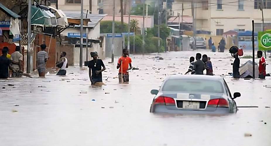
At 3:30 this morning (March 29, 2026), while Accra slept, the rains arrived. By dawn, Nima was underwater. Kaneshie was underwater. Dansoman, Kasoa, Mallam Junction, underwater. The Ghana Meteorological Agency had warned us 24 hours earlier. Power went out across Greater Accra. And Christians who had dressed for Palm Sunday church found themselves wading through streets that double as rivers.
This is not a story about rain. Ghana has always had rain. This is a story about what we have done with the land that rain is supposed to fall on, and what eleven years of political inaction has cost us.
June 1, 2015, Was Not a Turning Point. It Was a Warning We Ignored
On the night of June 3, 2015, a petrol station near the Kwame Nkrumah Interchange exploded while floodwaters surrounded it. At least 150 people died. Not from the rain, but from a fire that broke out because a fuel station was built metres from a floodplain in a city with no enforced land-use plan. The President declared three days of mourning. There were committees. There were promises. There were press conferences.
Then it rained again in 2016. And 2017. And 2018, when spillage from the Bagre Dam in Burkina Faso, a dam Ghana does not own and cannot control, flooded 23 communities and displaced nearly 32,000 people in the Northern Region. In 2019, a bridge in Accra collapsed under floodwaters. In 2021, Kumasi. In 2023, the Volta River Authority released water from the Akosombo Dam and wiped-out entire farming communities along the Volta basin. That same year recorded 20 separate flood incidents, the highest in recent memory.
And now, March 2026. The same streets. The same images. The same outrage that will last exactly until the water dries.
Since 1935, floods in Ghana have killed over 3,000 people, displaced more than 700,000, and erased an estimated one billion dollars in property and livelihoods FloodList. From 2013 to 2023 alone, floods caused economic losses of approximately $1.7 billion PreventionWeb, a different time range. These are not natural disaster statistics. They are the balance sheet of a country that keeps choosing short-term development over long-term survival.
We Are Not Solving the Right Problem
The national conversation about flooding in Ghana orbits one idea: choked gutters. Desilting exercise here. Taskforce there. And yes, the gutters are choked. But a choked gutter is a symptom. The problem is that we have built Accra against its own geography.
Floodplains that once absorbed rainfall are now concrete neighbourhoods. The Korle Lagoon, the Densu Delta, the Sakumo Wetlands, natural buffers that took thousands of years to form have been steadily encroached upon, built over, or turned into dumping sites. When rain falls on concrete where a wetland used to be, the water does not disappear. It moves into your living room, your shop, your child’s school.
This morning’s flooding is particularly instructive. March is the beginningof the minor rainy season in southern Ghana, typically a light warm-up before the heavy rains of May through July. The fact that a single pre-season shower was enough to submerge major urban communities tells us something chilling: the threshold for catastrophic flooding in Accra is now so low that any significant rainfall qualifies. We have engineered ourselves into permanent vulnerability.
West Africa’s climate is also shifting in ways that amplify this. Rainfall is becoming more intense and more compressed, the same annual volume arriving in shorter, more violent bursts. Research on Ghana’s rainfall patterns from 1992 to 2022 shows that years with heavy early-season rains (2018, 2019, 2021) were reliable predictors of severe flooding. These years are no longer anomalies. They are the forecast.
What Eleven Years of Failure Actually Means
Here is what a geographer sees when they look at the flood map of Ghana since 2015: a country that has normalised crisis. Every rainy season, the same communities flood. Every rainy season, the same officials express shock. And every dry season, the same land that flooded gets rebuilt upon, because the people living there have nowhere else to go and no policy framework protecting them from themselves or from the system that put them there.
Ghana does not lack flood data. The National Disaster Management Organisation has records. GMet has models. Researchers have published risk maps. What Ghana lacks is the political will to act on any of it before cameras arrive at a flooded street.
Three things must happen not eventually, but now. First, flood risk zoning must have legal teeth. Knowing which areas are high-risk means nothing if permits are still issued in those same areas for a fee. Second, transboundary water governance must become a foreign policy priority. Ghana cannot keep being surprised by dam spillages from upstream neighbours. Third, urban wetlands must be classified as protected critical infrastructure, not available for development regardless of who owns the land title.
This is Palm Sunday. In Christian tradition, it marks the beginning of the most consequential week of the year, a week that moves from celebration to crisis to, eventually, transformation.
Ghana has been in the crisis part of that cycle for eleven years. The transformation is overdue.
The water is telling us. The question is whether anyone in power is listening.
Author: Isaac Adutwum Osei
Bio: PhD Student in Geography and Environment, Western University, Canada
Email: [email protected]

 Miracles Aboagye arrest: 'You looted and your reaction is that the tables will t...
 Police arrest two with 73 parcels of suspected cannabis, reject GH¢300,000 bribe
 NACOC traces 73 assets linked to suspected drug traffickers
 Government seeks financial clearance to recruit 400 scientists – Armah Kofi-Buah
 Ya‑Naa Abubakari II laid to rest at Gbewaa Palace
 NPP will reinstate workers unlawfully sacked by NDC government - Chairman COKA
 'Neglecting grassroots dangerous' – GFL warns NDC, NPP
 'No money, no vote' — Bongo NPP delegates tell contestants in constituency execu...
 NAM1 files witness statements in Menzgold trial, seeks to rely on seven defence ...
 Miracles Aboagye’s wife raises health concerns over husband's detention by EOCO

