




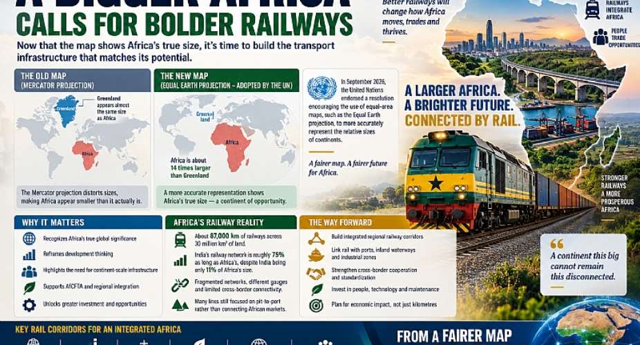
For generations, millions of people have looked at the world map without fully appreciating the true geographical scale of Africa. The familiar Mercator projection, which has dominated classrooms, offices, newsrooms and digital platforms for decades, significantly distorts the relative sizes of land masses. Greenland appears almost comparable in size to Africa, while Europe and other northern regions look disproportionately large. The geography itself was never wrong; its representation was. That long-standing perception is now receiving serious international attention. In September 2026, the United Nations General Assembly endorsed a resolution encouraging greater use of the Equal Earth projection and other equal-area maps when accurately representing the relative sizes of continents is important. The African-led initiative, spearheaded by Togo and supported by the African Union, does not ban the Mercator projection. Rather, it encourages governments, educational institutions, international organizations and technology companies to adopt mapping approaches that more accurately communicate geographical scale.
When Africa is presented using an equal-area projection, the visual difference is striking. Africa suddenly appears enormous. Or perhaps the better way to put it is that Africa finally looks like Africa. At approximately 30 million square kilometres, the continent is about fourteen times larger than Greenland. But the importance of this debate should extend beyond cartography. For Africa, seeing the continent at its proper scale should provoke a much deeper discussion about the infrastructure required to connect such an enormous geographical space. Once we begin appreciating Africa’s true dimensions, another distortion becomes increasingly difficult to ignore: the infrastructure connecting this vast continent remains far too fragmented for the geography and economic ambitions it is expected to serve. Nowhere is this contradiction more visible than in Africa’s railway infrastructure.
Look at an accurately proportioned map of Africa and then imagine laying the continent’s existing railway network across it. The gaps become extraordinary. Africa has tens of thousands of kilometres of railway infrastructure, but relative to its enormous landmass and population, rail connectivity remains limited and uneven. An especially revealing comparison comes from the Africa Finance Corporation: India occupies only a fraction of Africa’s land area, yet its railway network is comparable in overall scale to a substantial share of the entire African network. This should concern African transport policymakers, not because every part of Africa needs a railway, but because a continent of this physical scale requires far stronger high-capacity transport corridors than currently exist.
The deeper problem, however, is not simply that Africa has insufficient railway track. It is that much of the railway geography inherited by African countries was designed for an economic system fundamentally different from the one Africa is trying to build today. Colonial railway development was largely organized around extraction. Railways frequently connected mines, plantations and commodity-producing regions with coastal ports so that raw materials could be exported overseas. They were rarely conceived as components of an integrated continental economy connecting African production centres with African markets. This created what can essentially be described as a pit-to-port railway geography: resources moved outward rather than African economies being connected inward.
More than six decades after many African countries gained independence, elements of that geography remain visible. There are railway lines connecting mineral-producing areas to ports but inadequate connections between neighbouring countries. There are major ports whose hinterland railway connections remain insufficient. Landlocked countries continue to depend heavily on long-distance road freight. Different railway gauges and technical standards complicate cross-border interoperability, while national railway investments are still too often conceived as individual projects rather than components of continental logistics systems. Africa therefore faces an uncomfortable contradiction: it is geographically continental but infrastructurally fragmented.
This is why the renewed conversation about the world map matters beyond symbolism. Maps influence how societies understand distance, scale and possibility. If generations became accustomed to seeing Africa visually reduced, perhaps African infrastructure planning also needs to escape similarly constrained thinking. A continent of Africa’s actual dimensions cannot efficiently build its economic future predominantly around trucks and highways. Roads will always remain indispensable, particularly for local distribution and last-mile connectivity, but using trucks as the principal means of transporting minerals, containers, agricultural commodities and industrial goods over thousands of kilometres creates enormous economic and environmental costs. The greater the distance and freight volume, the stronger the strategic case becomes for rail and multimodal transportation.
Africa consequently needs railway infrastructure imagined on the scale of Africa itself. This does not mean drawing railway lines indiscriminately across the continent. It means replacing isolated national projects with strategically interconnected economic corridors. The railway of the future should not simply connect two cities because they happen to fall within the same national boundary. It should connect production centres, industrial zones, mines, agricultural belts, inland ports, seaports, logistics hubs and regional markets. National borders should increasingly become administrative boundaries rather than physical barriers to railway operations.
Encouragingly, parts of this transformation are already emerging. New and rehabilitated railway projects are appearing across several regions, while governments and development institutions are increasingly discussing transport development in terms of corridors rather than individual railway lines. Yet the continental network remains highly uneven. Southern Africa possesses some of Africa’s strongest railway concentrations, while cross-border railway connectivity remains considerably weaker in parts of West and Central Africa. Recent research mapping African transport infrastructure also demonstrates that portions of the existing network are disused, undergoing rehabilitation or still at the proposed stage. The next phase of railway development must therefore do more than reproduce the old network with modern locomotives and newer tracks. The geography of the network itself must evolve.
This evolution should also include Africa’s inland waterways. When the continent is viewed at its actual geographical scale, enormous river and lake systems become impossible to regard simply as geographical features. The Congo River system, Niger basin, Nile system, Lake Victoria, Lake Tanganyika and Ghana’s Volta Lake represent potential components of a much larger multimodal logistics architecture. Africa should therefore stop planning railways, inland waterways, roads and ports as independent transport sectors. Railway lines should meet inland ports. Inland waterways should connect landlocked production regions with rail corridors. Dry ports and logistics hubs should emerge where major transport modes intersect. Seaports should become gateways connected efficiently to their hinterlands rather than congested endpoints dependent primarily on trucking.
The African Continental Free Trade Area makes this transformation even more urgent. AfCFTA represents perhaps the most ambitious attempt in modern African history to transform dozens of fragmented national markets into a more integrated continental economy. But trade agreements can remove tariffs; they cannot remove distance. Infrastructure must do that. A Ghanaian manufacturer may theoretically gain access to markets in Burkina Faso, Côte d’Ivoire, Nigeria or even East Africa under continental integration, but that access has limited commercial meaning if moving goods across those distances remains expensive, unreliable or slow. Similarly, producers in landlocked economies such as Zambia, Niger, Burkina Faso, Uganda and Rwanda need competitive access to multiple regional gateways if they are to participate effectively in continental and global value chains. The true physical infrastructure of AfCFTA will therefore not be the trade agreement itself. It will be Africa’s transport corridors.
Imagine what the future African railway map could look like. West African economic centres could be connected through interoperable railway corridors rather than fragmented national networks. East African railway investments could integrate directly with Lake Victoria transport, allowing freight to transfer seamlessly between trains, ferries, ports and regional logistics centres. Southern Africa’s comparatively extensive railway system could strengthen its northward connections, giving mineral-producing and landlocked economies access to several competing ports. Ghana’s railway network could eventually integrate more effectively with Tema and Takoradi ports, industrial areas and the Volta Lake transport system, transforming the country into a multimodal logistics gateway for parts of West Africa. Across the continent, railway stations could evolve from simple passenger facilities into logistics, commercial and industrial nodes.
Such a vision, however, should not become an excuse for infrastructure expansion without economic discipline. Recognizing Africa’s enormous physical scale does not mean constructing railways everywhere. Railway infrastructure is capital-intensive, and poorly selected routes can become expensive national liabilities. Africa needs smarter railway expansion, not simply more railway expansion. Future investment should follow freight demand, population concentrations, industrial development, mining and agricultural activity, regional trade potential and multimodal connectivity. Existing lines should be rehabilitated where economically justified, interoperability should become an increasingly important consideration in new investments, and maintenance should receive the same political attention as groundbreaking ceremonies.
Most importantly, railway projects should increasingly be judged by what they connect, rather than simply how many kilometres of track they add. One hundred kilometres of railway connecting a major industrial cluster to a seaport, inland waterway or regional freight corridor may generate significantly greater economic value than several hundred kilometres of politically attractive track carrying insufficient traffic. The objective should therefore not be to cover Africa’s newly appreciated map with railway lines. The objective should be to connect the economic geography represented by that map.
There is also an institutional dimension that cannot be ignored. Continental railway integration requires governments to coordinate technical standards, customs procedures, border operations, investment priorities and infrastructure maintenance. Regional organizations such as ECOWAS, the East African Community, SADC and the African Union must increasingly become transport integration institutions rather than simply platforms for political cooperation. Corridor authorities capable of coordinating infrastructure across national borders may become particularly important. Without such institutional architecture, Africa risks constructing modern railway infrastructure while preserving the fragmented governance systems that prevented previous networks from achieving their full economic potential. The United Nations-backed movement toward more accurate world maps therefore carries a powerful message for Africa. Correcting how Africa appears on a map does not change the continent’s geography. What it changes is our perception of that geography. And perhaps that is precisely what African infrastructure development needs: a change in perception.
For centuries, the conventional world map visually underestimated Africa’s physical scale. For more than a century, Africa’s railway map has underestimated the continent’s potential for internal economic integration. One map is now being corrected. The other must be redesigned. Africa now has an opportunity to develop a transport geography shaped increasingly by its own economic ambitions rather than the extraction patterns inherited from the past. That means intelligent railway corridors connected to inland waterways, ports, industrial zones, logistics centres and neighbouring economies. It means planning infrastructure over decades rather than electoral cycles. And it means recognizing that continental free trade will ultimately succeed or fail according to whether African goods, businesses and people can physically move across this enormous geographical space efficiently.
The more accurately the world sees Africa, the more difficult it becomes to accept the continent’s current level of transport fragmentation. The new map should therefore become more than a correction in cartography. It should become a challenge to African policymakers, railway authorities, development institutions and regional organizations to think at the true scale of the continent they are trying to transform.
Because once we see how large Africa really is, one conclusion becomes impossible to ignore: a continent this big cannot remain this disconnected.
Author: Joseph Fuseini ([email protected])


 NGSJF petitions Ghana Airports, IGP over Adwoa Safo travel records and 2021 parl...
 Transport Minister directs DVLA to deepen inter-agency collaboration towards enf...
 Famers at Anloga-Avume call for buyers, govt intervention as tomatoes rot in far...
 2026 World Cup: 'Minister’s driver, Chief Director’s secretary still in US' – Mi...
 Ho Central NPP threatens retaliation over demolition of party office fence wall ...
 Trump says 'major progress' made toward US military base in Poland
 US aid cuts are killing Kenyan sex workers
 37 suspected illegal miners die in custody in central Nigeria
 'When I go to sleep, I know I haven’t done anything wrong' – Finance Minister
 Trump threatens EU with tariffs over 'laughable' Canada association plan


