



Every map you have ever seen is an argument that has learned to look like a fact.
Think back to your first geography lesson, maybe in a classroom in Kumasi, Lagos, Nairobi, London or Toronto. A big colourful map hung on the wall. Greenland sat in the top corner looking almost as large as Africa. Nobody asked why. Nobody had to. The map had already answered for us.
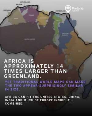
Here is what that map did not say. Africa is about 14 times larger than Greenland. The United States, China, India, Japan and most of Western Europe can fit inside the African continent with room left over. The map we all trusted was drawn in 1569 by the Flemish cartographer Gerardus Mercator, and it was built for one job: helping ships hold a steady compass course. For that job it was brilliant. As a picture of how big places are, it was never meant to be believed. We believed it anyway, for 457 years.
How a sailor's tool became a worldview
Mercator's trick is simple. To keep compass lines straight on a flat page, the map stretches the land more and more as you move away from the equator. Greenland, Canada, Russia and Europe balloon. Africa, South America and South Asia, which sit near the middle, look shrunken by comparison.
None of this is a secret to cartographers. The problem is what happens when a navigation tool escapes the ship and moves onto the classroom wall, the news graphic and the boardroom slide. A tool for steering becomes a lesson about importance. Big on the page quietly turns into big in the mind.
Moky Makura, who runs Africa No Filter, one of the groups behind the Correct the Map campaign, called it "the world's longest misinformation and disinformation campaign." You can argue about the word "campaign," because nobody sat in a room plotting. But you cannot argue with the result. Generations of children, investors, diplomats and journalists absorbed the same hierarchy without ever choosing it.
The map and the machinery
This is where it stops being a geography debate. The same era that gave us the Mercator map gave us the machinery of empire. In 1884, delegates in Washington agreed on Greenwich as the world's zero meridian. That same year the European powers sat down in Berlin to carve up a continent most of them had never walked. Borders were drawn with rulers on tables thousands of kilometres from the people living there.
Maps did not merely record those decisions. They made them feel natural and permanent.
Here in Ghana we carry an odd privilege in this story. The Greenwich Meridian passes through Tema. And the point where the equator meets the prime meridian sits in the Gulf of Guinea, just off our own coast. Geographers sometimes joke that Ghana is closer to the centre of the world than any other country. Yet generations of Ghanaian schoolchildren grew up looking at a map where the centre of the world was somewhere in Europe, and their own country looked like a footnote in the lower middle.
That is the real cost. It is not that someone made a mistake. It is that a child learns, long before she can say it, that her place is small.
The campaign that refused to stay symbolic
The movement to fix this did not begin in a government office. In 2025, two African civil society groups, Africa No Filter and Speak Up Africa, launched Correct the Map and pushed for the Equal Earth projection, an equal-area design released in 2018 by a team of cartographers led by Tom Patterson. On Equal Earth, the size of a country on the page matches its real size on the planet. The shapes bend a little at the edges, but the proportions are honest.
Then it moved fast. In August 2025 the African Union endorsed the campaign. Its deputy chairperson, Selma Malika Haddadi, said the old map had entrenched the stereotype that Africa is marginal, when it is the world's second-largest continent with well over a billion people. The World Bank said it was phasing out Mercator on its web maps. In early 2026 the AU adopted Equal Earth as its own institutional standard. Togo, led by Foreign Minister Robert Dussey, then carried the idea to the UN.
On 4 September 2026, the General Assembly voted 164 to 1, with six abstentions, to adopt the "Correct the Map" resolution. It was put forward by AU member states and the Bahamas, with France among the co-sponsors. Ahead of the vote, France's foreign minister announced his ministry would abandon Mercator in favour of maps more faithful to real surface areas.
I want you to sit with how unusual that is. In a world where the UN struggles to agree on almost anything, the planet's governments agreed that a 450-year-old picture of the Earth needed correcting.
The honest objections
A serious piece has to give the other side its due, because there is one.
The United States was the only country to vote against. Its argument was that the resolution promotes an "ideological agenda" and distracts from the real problems of international peace and prosperity. Some people will find that persuasive, so it deserves a straight answer. Is a map really a priority when there are wars, debts and hunger to deal with?
My answer is that the two things are not rivals. Correcting a map costs almost nothing compared with the harm of teaching a billion children to underestimate a continent. And the resolution itself is modest. It is not legally binding, and Togo's government made clear it does not challenge Mercator's use for sea and air navigation, where it remains perfectly suited. No pilot is being told to throw away a chart.
There is a second, quieter objection from the cartographers themselves. No flat map is perfect. Equal Earth keeps sizes true but bends shapes. Every projection trades something away. That is exactly the point. The goal was never one perfect map. It was to stop pretending one distorted map is the world.
And there is an implementation problem. A vote in New York does not rewrite a textbook in Helsinki, or reset the default view on your phone. One Finnish publisher has already said it will not rush to replace its maps, and some major map apps still default to the old projection on mobile. Makura said as much herself: "now the real work begins."
What this means for the rest of us
This is where I stop being a reporter and speak as a writer.
For my Ghanaian and African readers: this is not about vanity. A child who grows up seeing her continent at its true scale is a child who is slightly harder to talk down to. Confidence is a kind of capital. It shows up later in how a young entrepreneur pitches an investor, how a negotiator sits at a climate table, how a country prices its cocoa and its gold. Makura said it better than any of us could: "Africa doesn't need to be made bigger. It needs to be seen accurately."
For my readers in the diaspora, in London, Toronto, Houston and Hamburg: look at the map in your child's school. Ask which projection it is. It takes thirty seconds, and it is a conversation worth having at a parents' evening.
For my international readers: the old map did not only shrink Africa. It also inflated Europe, Russia and North America. Fixing it corrects the picture for everyone, including the Middle East, South America and South Asia. A fair map is not a favour to Africa. It is a favour to anyone who wants to see the world as it is.
The lesson under the lesson
When Ghana walked into independence in 1957, Kwame Nkrumah told the world that the new nation's freedom would be meaningless unless it was linked to the total liberation of the continent. Freedom, in that sense, was never only about flags and anthems. It was about who gets to describe you.
A map is a description. For 457 years, somebody else held the pen. In September 2026, the world agreed that Africa could hold it too.
If we got something as basic as the size of a continent wrong for this long, what else have we simply accepted without asking? That is the question I want you to take away. Not "what does the new map look like?" but "what else are we looking at that was drawn for somebody else's purposes?"
The ink is still drying. The textbooks, the apps and the classroom walls are next. The technology already exists. The only thing left is whether we have the will to use it.
Chief Tutu Baffour Asare Brownsy Williams is an author, columnist and filmmaker, an international global human rights defender and a public health advocate.

 “She kissed me first” – Labone SHS French teacher tells court in indecent assaul...
 NDC enjoying benefits of NPP's difficult economic decisions – Fuseini Issah
 Improved economy justifies purchase of new presidential jet – Toobu
 Eight Ghanaian seafarers return home after months in Iranian detention
 No one will be allowed to mess around with a Ghanaian and get away with it – Abl...
 Exim Bank case: Wontumi offers GH¢25m to secure end to prosecution
 Gov't finds $60.68m for presidential jet despite cost-of-living concerns – Abu J...
 Mahama orders performance assessment of all 261 MMDCEs
 Fitch Solutions projects cedi will weaken to GH¢12.40 against dollar in 2027
 I think Mahama done better than the first term – Archbishop Agyinasare


