



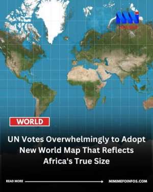
The United Nations General Assembly has taken a significant step toward correcting one of the world's most enduring geographical distortions by backing the use of a world map that represents Africa more accurately in relation to other continents.
For generations, the familiar Mercator projection has dominated classrooms, offices, textbooks and public institutions around the world. Although useful for navigation, the projection significantly distorts the relative sizes of land masses, particularly those farther from the equator.
Africa has been one of the biggest victims of this distortion.
In reality, Africa is enormous. With an area of about 30 million square kilometres, it is the world's second-largest continent after Asia. Yet on many conventional world maps, Africa appears considerably smaller in comparison with regions such as Europe, Greenland and North America.
This is not simply a question of cartography. Maps influence how people understand the world.
When generations of children grow up seeing Africa portrayed as smaller than it actually is, that visual representation can subtly influence perceptions of the continent's geographical importance and place in the world.
The move toward a more proportionally accurate map therefore carries considerable symbolic significance for Africa.
Correcting a Historical Distortion
The Mercator projection was developed by Flemish cartographer Gerardus Mercator in 1569. Its primary purpose was navigation rather than accurately comparing the sizes of continents.
Because the Earth is spherical, representing it on a flat surface inevitably creates some form of distortion. The Mercator projection preserves angles and shapes locally but increasingly exaggerates land areas toward the poles.
This explains why Greenland can appear almost comparable in size to Africa on some maps, even though Africa is roughly 14 times larger.
More equal-area approaches provide a very different picture. They show the true scale of Africa and offer viewers a more realistic comparison between continents.
Africa's Size Matters
Africa's true geographical scale reflects the enormous diversity contained within the continent.
It is home to more than 50 countries and over a billion people, with vast agricultural lands, mineral deposits, forests, rivers, renewable-energy potential and an increasingly youthful population.
The continent is also becoming more important to global discussions about climate change, critical minerals, food security, energy transition, trade and the future of the global workforce.
Accurately representing Africa on the world map therefore matters beyond geography.
Time to Rethink What We Teach
African governments and educational authorities should use this development as an opportunity to examine the maps being used in schools.
Children deserve educational materials that help them understand the world as accurately as possible. Geography textbooks, classroom maps, digital learning platforms and public institutions should increasingly adopt projections that communicate relative land areas more faithfully.
Ghana and other African countries should be among those leading this transition.
For too long, Africa's representation in global institutions, economic structures and even the maps hanging on classroom walls has not always reflected its true weight.
Changing a map will not solve Africa's development challenges. It will not create jobs, industrialise economies or eliminate poverty.
But representation matters.
A map is more than lines, colours and borders. It shapes our mental picture of the world.
If Africa is one of the largest, most resource-rich and increasingly consequential regions on Earth, then the maps through which the world sees it should reflect that reality.
Africa has not suddenly become bigger. The world is simply being encouraged to see how big Africa has always been.


 US envoys arrive in Moscow to thrash out plan to end war in Ukraine
 'Chief Justice was talking as a citizen; you have to look at the context in whic...
 Mandatory towing to remove broken-down, stationary vehicles from roads to begin ...
 Domelevo backs OSP probe into alleged GH¢70,000 payment to Appiagyei despite den...
 WAEC releases 2026 WASSCE results, cancels entire results of 861 candidates for ...
 Baffour Agyeman-Duah explains why profitability may not be only reason behind SO...
 Kofi Bentil defends Mahama’s dissolution of nine State Boards
 5-year-old girl dies after falling into water-filled manhole at Winneba
 Sierra Leone ex-president to return after treason case dropped
 Ghana ends South Africa evacuation; brings home nearly 1,900

