
Surveillance, Sovereignty, and the New Espionage
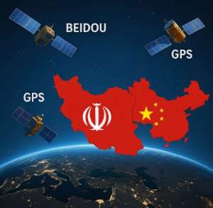
In an era where metadata equals targeting data, the shift from GPS to BeiDou offers Iran not only tactical autonomy but strategic ambiguity. Iranian officials allege that foreign powers exploited Western apps to triangulate senior leadership positions, leading to drone assassinations and missile strikes. In response, Iran orchestrated a nationwide digital purge, urging 90 million citizens to delete Meta-owned applications, and implemented near-total internet blackouts during escalations.
This digital retrenchment aligns with BeiDou's encrypted pathways and satellite-to-ground messaging capacities, which enable secure communications even in the absence of terrestrial networks. On a militarized battlefield, such tools become the sinews of resilience. More profoundly, the move signals a redefinition of sovereignty, not merely in terms of borders, but in the ownership of signals and code.
What emerges is a broader civilizational risk, the conversion of metadata into ordnance. In an era where nearly every human carries a GPS or BeiDou-enabled smartphone, location tracking can be silently weaponized. Intelligence reports and open-source investigations suggest that Israeli airstrikes against Hezbollah and IRGC operatives, including those outside conventional war zones, have relied not only on direct intelligence but on triangulated metadata harvested from mobile applications. While companies like Meta and Google deny intentional sharing of real-time location data, cybersecurity experts warn that metadata, timestamps, location histories, Bluetooth signals, and device IDs, can be exploited by states with surveillance-grade infrastructure.
Moreover, the danger is no longer limited to smartphones alone. Increasingly, security apparatuses rely on GPS-linked or satellite-synced devices such as encrypted walkie-talkies, body-worn cameras, and portable digital transponders, each a beacon in a digitized battlespace. These tools, while indispensable for coordination and communication, double as signal-emitting liabilities when intercepted or spoofed. The dual-use nature of modern tactical hardware collapses the boundary between operational utility and digital exposure.
In a chilling extension of metadata weaponization, Tehran claims that the IAEA itself turned into an intelligence conduit, leaking nuclear scientist identities that preceded a wave of assassinations, another reminder that sovereignty can be shattered not just in orbit, but in the halls of global institutions.
For ordinary civilians and military personnel alike, this creates a paradox of modernity, participation in the digital commons renders one locatable, traceable, and, under certain wartime conditions, expendable. In this light, sovereignty is no longer only a matter of state architecture, but of personal signal discipline. In theatres like Gaza, Lebanon, or even Tehran, the phone in your pocket, or the radio on your shoulder, may be your most dangerous possession.
Silent Retaliation: The Implications of GPS Jamming and U.S. Restraint
Unconfirmed but widely circulated reports suggest that Iran may have successfully jammed or disrupted GPS signals guiding U.S. fighter jets during an aerial standoff in June 2025. Subsequent U.S. airstrikes involving B-2 bombers carrying bunker-busting payloads on Iranian nuclear sites appeared deliberately restrained, perhaps indicating that electronic warfare parity is beginning to shift.
The implications are sobering. If traditional GPS-guided systems can be neutralized by peer-level adversaries using alternative satellite constellations and electronic countermeasures, the presumed asymmetry of Western military technology could be eroding. U.S. strategic restraint may now be shaped not only by political calculus but by vulnerabilities in the orbital domain.
The BeiDou-GLONASS Axis and the Future of BRICS Geopolitics The deeper integration between BeiDou and Russia's GLONASS augurs a new techno-political alignment. This emerging PNT axis facilitates seamless navigation coverage from Vladivostok to Caracas, with Iran, Pakistan, and potentially other BRICS members in tow. Unlike the GPS-aligned world, where access can be weaponized through sanctions, this alternative system is designed for political insulation and resilience.
To fully grasp China’s ascendant space posture, one must look beyond the satellites alone. With nearly 48 active satellites, BeiDou now eclipses GPS’s fleet of 31, bolstered by an expansive mesh of global ground monitoring stations, reportedly more than ten times those operated by the U.S. Above, the Tiangong space station, modular and crewed, signals Beijing’s long-term orbital ambitions. These layers of space infrastructure—satellites, ground nodes, and orbital platforms, construct a resilient and sovereign PNT architecture that challenges American monopoly and primes China as the dominant force in the heavens.
Yet questions of trust persist, can Iran fully entrust its sovereignty to China? While Beijing lacks Western-style transparency and privacy protections, it presently offers Tehran a strategic sanctuary. The relationship is not without risk; dependency merely shifts East. But for states outside the Western security umbrella, such dependencies may be preferable to subordination.
At the same time, this strategic realignment enhances Iran’s geopolitical posture. By embedding itself within China's BeiDou ecosystem, arguably the most rapidly advancing satellite architecture, Iran gains access to cutting-edge electronic warfare capabilities, ultra-precise navigation for its drones and missile systems, and encrypted military communications less susceptible to Western disruption. In the context of the ongoing regional conflict, these capabilities are not abstract—they shape the velocity, accuracy, and survivability of Iran’s military assets. Precision in warfare is no longer theoretical; it is a matter of whose signal guides the strike.
As for the United States, its response remains one of caution—not due to diminished will, but due to recalibrated risk. The era of unilateral orbital dominance is closing. The GPS digital empire, once unassailable, now faces a multipolar constellation reality. Future American responses—militarily or diplomatically—will have to acknowledge this loss of infrastructural supremacy.
The End of the Digital Monopole Iran’s embrace of BeiDou represents more than a technological upgrade. It marks the dissolution of the United States’ monopolistic hold over the world's most vital satellite system. As BRICS nations arm themselves with alternative constellations, the global order of PNT supremacy is splintering. The age when American satellites invisibly governed the movement of goods, troops, and data across the planet is coming to a close.
In this brave new world, satellites are no longer mere navigational aids, they are the new cartographers of power. The contest for control is no longer fought only on land, sea, or air, but in signals, in orbits, and in code. In the emergent techno-sovereign age, who controls the satellite, controls the signal, and who controls the signal, controls the story.

 Investigation committee uncover GH¢19.5m loss at Bolgatanga Technical University...
 NLC orders doctors at KATH to call off strike as dispute over CEO suspension esc...
 Avenor building collapse: ‘A pillar fell before total crash’ — Survivor narrates
 Ibrahim Mahama offers 100 jobs to Ghanaian evacuees from South Africa
 We helped you evacuate Ghanaians but we won't tolerate the public spectacle devo...
 Afenyo-Markin calls for protection of journalists, warns against suppression of ...
 Structural failures driven by poor standards compliance, not sudden collapse tre...
 US$7.8 billion in remittances shows value of Ghanaians abroad – Ablakwa
 Evacuated Ghanaians from South Africa make nation proud with clean security reco...
 Death toll rises to two as rescue efforts continue in Avenor building collapse


Comments
The author, Kennedy Opoku, was a minute too late; your posted write-up should have gone to our former economic whiz kid turned digitalization fraud kingpin who, in conspiracy with others in the Akufo-Addo/Dr. Bawumia government administration wasted money painting rusty vessels with gold. Where would sub Sahara African (SSA) nations be today with our communications and satellite aided navigation tools and equipment if we had provided funding, in cooperation with other SSA nations, to send 3...
Author's Reply
Yabi Yabi, I couldn’t agree more on the tragic comedy of how our so-called economic “geniuses” turned innovation into a cash-burning circus. But my article goes beyond the personalities and paints the real picture, that sovereignty in the digital age isn’t measured by political slogans or photo-ops, but by who owns the satellites, the signals, and the skies. If even a fraction of the money wasted painting rust into gold had been channelled into a joint African satellite programme, we’d be writing a different story today — one of technological independence, not political showmanship