
On 27th December 2018, registered voters in four Municipalities and seven districts in the Eastern part of the Brong Ahafo region voted massively for the creation of the new Bono East region.
In all, 448,545 voters out of 525, 275 registered voters representing 99.50 percent of valid votes cast voted to affirm the creation of the new Bono East region.
The figures as put out by the Electoral Management body represent 85.82 percent of voter turnout, a figure way above the constitutional threshold of 50 percent.
Now that the referendum is over, the next stage is the siting of the regional capital which has been characterised by series of lobbies by key players in spite of government’s indication that the process of naming regional capitals for the six new regions will be dependent on the advice of technocrats.
Notwithstanding this, there is no doubt when it comes to where the capital of the Bono East should be sited.
At a glance, there are other competitors in the quest to be the capital but Atebubu has a greater advantage over any other competitor.
Below are some detailed reasons why the capital should be situated at Atebubu, the capital of the Atebubu-Amantin Municipal.
Proximity
The land area of the proposed Bono East is about 25, 314 square km representing about two- thirds or 68 percent of the entire land mass of the Brong Ahafo region.
The land mass is also 10 percent of Ghana’s total land size. According to the final report by the commission, spatial issues such as travel times and distances between the regional capital and the various districts was raised 187 times during the public hearing.
For example, the distance from Kajaji(the farthest of the region), Kwame Danso and Yeji to Sunyani are 292km, 239 and 264km respectively and it is only proper to armeliorate their predicament by choosing a location closer to them.
In view of this, it is only fair and prudent for the capital to be situated at Atebubu a location that is centrally positioned, strategically and administratively closer to all other towns in the new region.
The town is also the gateway to four other regions, that is, Ashanti region, Northern region, Eastern region and Volta region.
Siting the regional capital at any place apart from the centre (Atebubu) will not only be naturally biased but will also defeat the petitioners’ own request for a region.
This fact is buttressed by the petitioners’ own argument as captured by the final report of the commission that: ” The petitioners justified based on the creation of the new region on the following: need to deepen governance and bring government and its agencies and activities closer to the people…”
This issue was the most dominant during the public hearings as it was raised 209 times representing 20.5 percent of issues raised.
For the avoidance of doubt, Abuja the capital of the Federal Republic of Nigeria was chosen when the government wanted to build a new capital to replace Lagos due to its close proximity to all the regions of Nigeria.
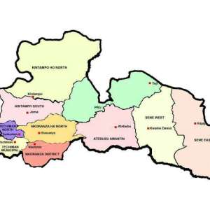
A closer look and critical analysis of the administrative map of the new region below backs the argument espoused above.
Unmitigated and litigate free lands for development
Aside being centrally positioned to be easily accessed by the other Municipals and districts, Atebubu has vast lands to aid in the huge expansion that may come with the siting of the regional capital.
The siting of the regional capital irrespective of where it is situated will lead to massive infrastructural drive and the influx of many people hence the need to consider an area that is not “chocked” for such a purpose.
It is in this regard that the chiefs in the Atebubu Traditional Area have indicated their willingness and preparedness to release lands which are litigate free to devour developments that will come with the siting of the capital.
They have also revealed their preparedness to help in any way possible to ease the pressure on the government if the capital is sited in Atebubu.
One reason the petitioners eloquently put before the Justice S. A. Brobbey’s Commission of inquiry for the creation of new regions and captured same in the final report of the commission is “the need to deepen governance and bring government and its agencies and activities closer to the people, equitable and distribution of statutory funds and development projects; the enhancement of infrastructural development and access to services…”
In recent times, there have been calls for the national capital to be moved from Accra to a different place due to how packed the capital looks in terms of vehicle traffic, population density and buildings.
So if an opportunity has presented itself, is it not appropriate for the government to consider siting the capitals of the new regions in areas whose development can be modeled on modern developmental trends?
Who sites a regional capital in an area that is already populous and developmentally chocked when rural-urban migration figures in the country are very alarming?
A deviation from some of these core principles at this time will not only be morally wrong but strange and interesting.
History
Historically, Atebubu was the headquarters of the then Bono East Confederacy which was formed in 1893. The membership included a greater part of Nsuta and Mampong, Nkoranza, the Krachi Denteh Priest, Kwahu, Atebubu and all Guan communities around Salaga.
For emphasis, the term Bono East is not of modern origin but has a historical antecedent dating back to over a century ago so it is only fair we revisit the history books.
Atebubu was the hub of the then Bono East and so it is only fair and proper for the right thing to be done now.
If a new region has been created bearing the old name then it should be copied in full, not in part.
History indeed has an interesting way of repeating itself. “Obi nnim a, obi kyere( If one does not know, another man teaches him)
The True definition of Bono East
Without any shred of doubt, Atebubu and its surrounding towns like Prang, Yeji, Kwame Danso and Kajaji for decades became notoriously synonymous with the name “Bono East people” because of their location.
They proudly shouldered the name even though it sometimes had some derogatory connotations(“deprived areas”)
So if a new region is to be created bearing that name, it is only fair that one of the forebearers of the area(name) should be the Capital, in this case, Atebubu since it gave birth to all neighbouring districts.
Effective Administration
The location of Sunyani made it difficult for districts farther away to access critical services. This was because the travel distance from some of the districts to the regional capital took a whole day.
It also affected government officials in the effective discharge of their duties as districts farther away from the capital also escaped proper supervision and monitoring.
Page 207(45) of the commission’s own report reads: “the regional government set up, ministries, departments and agencies have difficulties in smooth administration of the region because of its vast expanse. It was practically impossible to reach some communities to undertake, supervise and monitor development projects.
“When such trips are eventually undertaken personnel have to forgo considerable amount of man hours to travel with additional implication on cost. In most cases, the proposed Bono East region is adversely affected, since it has the farthest communities…”
Taking a cue from this, why place the regional capital at say Techiman or Nkoranza which are still the farther from the other administrative towns?
Won’t the regional Minister still struggle to do effective monitoring and supervision? What is the essence of creating a new region and situating the capital at some 62km or 89km from Sunyani.
What benefit will it bring to the people of Kajeji and Kwame Danso if they still have to travel some 224km to access the capital.
The answer to this puzzle still remains Atebubu.
Gap in development
It is a known fact that the eastern corridor of the Brong Ahafo region lags behind in terms of development. Areas such as Atebubu, Prang, Kwame Danso, Kajeji and Yeji lack basic social amenities compared to their other compatriots, that is, Techiman, Kintampo and Nkoranza.
During the public hearings, it was the view of most residents that the creation of the new region will “bridge the spatial inequality gap and promote rapid development…”
So if any region is to be created, it will only be fair and appropriate for the capital to be sited in that enclave to bridge the infrastructural gap. The proponents for the creation of the Bono East region rode on the back of infrastructural deficit to achieve that purpose so why run from it now?
Yes, Atebubu has none of the so-called big institutions that some its competitors can boast, but let us not forgot the Akan proverb that “obi nnim Obrempon ahyease” to wit “Nobody knows the beginning of a great man”.
He who is full they say needs no food.
The oldest district in the Bono East enclave
When Ghana’s former President, Kwame Nkrumah created the Brong Ahafo region April 4, 1959, the region was divided into four districts. The regions were the Atebubu district, Sunyani district, Ahafo district and Wenchi district.
The Atebubu Assembly, one of the oldest Assemblies in the Brong Ahafo region if nothing at all should be rubbing shoulders with its peers like Sunyani.
If Sunyani has risen from the ruins to be such a befitting regional capital why can’t Atebubu too?
“Monkeys they say play by sizes”, Atebubu the oldest among all Assemblies in the Bono East enclave deserves its rightful recognition.
“The mouth of an elderly man is without teeth, but never without words of wisdom.”
It is now or never, Atebubu for Bono East regional capital is a must and non-negotiable. Don’t be left out, join the train now.
 "I can now see clearly with my two eyes, thanks to the generosity of Afenyo-Mark...
 Amansie Central: Violent rainstorm causes havoc at Jacobu; one dead
 Renaming Ho Technical University after Ephraim Amu is illegal – Minority slams g...
 Gomoa Akotsi: Truck crashes into police vehicle, one dead, several officers inju...
 Election 2024: Power outages will affect NPP – Political scientist
 NPP is 'a laughing stock' for luring 'poster-stickers', 'noisemaking babies' wit...
 Dumsor: Matthew Opoku Prempeh must be removed over power crisis – IES
 PAC orders WA East DCE to process requests from their MP
 Defectors who ditched Alan’s Movement to rejoin NPP were financially induced – A...
 Dumsor: Akufo-Addo has taken Ghanaians for granted, let’s organise a vigil – Yvo...
